
Bank Fishing Opportunities in Illinois
You can bank on some excellent bank fishing opportunities from the shores of the 1.5 million acres of water in Illinois. From the deep blue waters of Lake Michigan to the many great rivers and crystal-clear lakes and ponds, Illinois bank fishing opportunities abound.
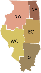
To locate a bankfishing opportunity near you, refer to the state regions and click the corresponding tab.
Legend
 Family Friendly
 Wheelchair Accessible
 Picnicking Available
 Camping Available
- Text in red indicates the location is PRIVATE
and requires permission for use.
- LMB Largemouth bass
- SMB Smallmouth bass
- SPB Spotted bass
- BLG Bluegill
- SUN Sunfish
- CRP Crappie
- CCF Channel catfish
- BUL Bullheads
- CAP Carp
Waterbody |
Location |
Access Point |
LMB |
SMB |
SPB |
BLG |
SUN |
CRP |
CCF |
BUL |
CAP |
ALEXANDER County |
|---|---|---|---|---|---|---|---|---|---|---|---|
CACHE R MISS | SE of Sandusky |
USFWS Boat Ramp(s) |
x |
x |
x |
x |
x |
x |
x |
||
Waterbody |
Location |
Access Point |
LMB |
SMB |
SPB |
BLG |
SUN |
CRP |
CCF |
BUL |
CAP |
Alexander County |
HORSESHOE LAKE - ALEXANDER | Olive Branch |
Boat ramps, park, spillway, pier |
x |
x |
x |
x |
x |
x |
x |
||
Waterbody |
Location |
Access Point |
LMB |
SMB |
SPB |
BLG |
SUN |
CRP |
CCF |
BUL |
CAP |
ALL County |
ILLINOIS RIVER | Detweiler Marina, Peoria |
Boat Ramp(s) |
x |
x |
x |
x |
x |
x |
x |
x |
|
ILLINOIS RIVER | Galena park, peoria |
Boat Ramp(s) |
x |
x |
x |
x |
x |
x |
x |
x |
|
ILLINOIS RIVER | Route 9 bridge, Pekin |
Boat Ramp(s) |
x |
x |
x |
x |
x |
x |
x |
x |
|
ILLINOIS RIVER | Chillicothe Park, Chillicothe |
Boat Ramp(s) |
x |
x |
x |
x |
x |
x |
x |
x |
|
ILLINOIS RIVER | Wesley Road, Bartonville |
Boat Ramp(s) |
x |
x |
x |
x |
x |
x |
x |
x |
|
MISSISSIPPI RIVER | 2.4 miles SE of Alton |
Melvin Price Lock & Dam Access Area |
x |
x |
x |
x |
x |
x |
x |
x |
x |
MISSISSIPPI RIVER | Warsaw |
Warsaw Public Access |
x |
x |
x |
x |
x |
x |
x |
x |
|
MISSISSIPPI RIVER | 5 miles SSW of Hull |
Park-N-Fish Recreation Area |
x |
x |
x |
x |
x |
x |
x |
x |
|
MISSISSIPPI RIVER | Crosses Corner |
Boat Ramp(s) |
x |
x |
x |
x |
x |
x |
|||
MISSISSIPPI RIVER | Oquawka |
Boat Ramp(s) |
x |
x |
x |
x |
x |
x |
|||
MISSISSIPPI RIVER | 2 miles NW of Mozier |
Rip Rap Landing |
x |
x |
x |
x |
x |
x |
x |
x |
|
MISSISSIPPI RIVER | Savanna City Park |
Park shoreline |
x |
x |
x |
x |
x |
x |
x |
x |
|
MISSISSIPPI RIVER | 6 miles W of Marcelline |
Bear Creek Recreation Area |
x |
x |
x |
x |
x |
x |
x |
x |
|
MISSISSIPPI RIVER | 1.5 miles S of Cairo |
Fort Defiance Park |
x |
x |
x |
x |
x |
x |
x |
x |
x |
MISSISSIPPI RIVER | 5.5 miles SW of Atlas |
Two Rivers North Access |
x |
x |
x |
x |
x |
x |
x |
x |
|
MISSISSIPPI RIVER | Albany |
Albany Boat Ramp |
x |
x |
x |
x |
x |
x |
x |
x |
|
MISSISSIPPI RIVER | 5 miles SW of Grafton |
Royal Landing |
x |
x |
x |
x |
x |
x |
x |
x |
|
MISSISSIPPI RIVER | Chester |
Chester Riverfront |
x |
x |
x |
x |
x |
x |
x |
x |
|
MISSISSIPPI RIVER | Alton |
Alton Marina Boat Ramp |
x |
x |
x |
x |
x |
x |
x |
x |
|
MISSISSIPPI RIVER | Sunset Marina, Rock Island |
Sunset Park |
x |
x |
x |
x |
x |
x |
x |
x |
|
MISSISSIPPI RIVER | 1.4 miles W of Hamilton |
Montibello Public Access |
x |
x |
x |
x |
x |
x |
x |
x |
|
MISSISSIPPI RIVER | 2.75 miles SSW of Quincy |
Lock & Dam 21 Recreation Area |
x |
x |
x |
x |
x |
x |
x |
x |
|
MISSISSIPPI RIVER | 8 miles W of Hull |
John Hay Recreation Area |
x |
x |
x |
x |
x |
x |
x |
x |
|
MISSISSIPPI RIVER | Keithsburg |
Boat Ramp(s) |
x |
x |
x |
x |
x |
x |
|||
MISSISSIPPI RIVER | Delabar State Park |
Boat Ramp(s) |
x |
x |
x |
x |
x |
x |
|||
MISSISSIPPI RIVER | Grand Tower |
Grand Tower Public Access |
x |
x |
x |
x |
x |
x |
x |
x |
x |
MISSISSIPPI RIVER | 4.3 miles S of Hamburg |
Red's Landiing |
x |
x |
x |
x |
x |
x |
x |
x |
|
MISSISSIPPI RIVER | 0.8 miles S of Meyer |
Meyer Public Access |
x |
x |
x |
x |
x |
x |
x |
x |
|
MISSISSIPPI RIVER | 4 miles NNW of Granite City |
Chain of Rocks Dam Access |
x |
x |
x |
x |
x |
x |
x |
x |
x |
MISSISSIPPI RIVER | Thebes riverfront |
Thebes Boat Ramp |
x |
x |
x |
x |
x |
x |
x |
x |
x |
MISSISSIPPI RIVER | 3.3 miles WSW of Rockport |
Willow North Access |
x |
x |
x |
x |
x |
x |
x |
x |
|
MISSISSIPPI RIVER | Dallas City |
Boat Ramp(s) |
x |
x |
x |
x |
x |
x |
|||
MISSISSIPPI RIVER | 3 miles SW of Ellis Grove |
Kaskaskia River Lock & Dam Access |
x |
x |
x |
x |
x |
x |
x |
x |
|
MISSISSIPPI RIVER | Quincy |
Quincy Riverfront |
x |
x |
x |
x |
x |
x |
x |
x |
|
MISSISSIPPI RIVER | New Boston |
Boat Ramp(s) |
x |
x |
x |
x |
x |
x |
|||
MISSISSIPPI RIVER | Putneys Landing, Big River State Forest |
Landowner Permission Required |
x |
x |
x |
x |
x |
x |
|||
MISSISSIPPI RIVER | 4 miles E of Elsah |
Piasa Harbor Public Access |
x |
x |
x |
x |
x |
x |
x |
x |
|
MISSISSIPPI RIVER | 5.5 miles SSW of Atlas |
Gosline Access |
x |
x |
x |
x |
x |
x |
x |
x |
|
MISSISSIPPI RIVER | 1 mile NW of Grand Tower |
Devil's Backbone Park |
x |
x |
x |
x |
x |
x |
x |
x |
x |
MISSISSIPPI RIVER | 3 miles NW of Batchtown |
Turner Landing |
x |
x |
x |
x |
x |
x |
x |
x |
|
MISSISSIPPI RIVER | Savanna |
Mississippi Palisades State Park |
x |
x |
x |
x |
x |
x |
x |
x |
|
MISSISSIPPI RIVER | 1.8 miles SSW of Hartford |
Lewis & Clark State Park |
x |
x |
x |
x |
x |
x |
x |
x |
x |
MISSISSIPPI RIVER | 5 miles SW of New Canton |
Cincinnati Landing Access |
x |
x |
x |
x |
x |
x |
x |
x |
|
MISSISSIPPI RIVER | Lock and dam 18 tailwater |
Most of Shoreline |
x |
x |
x |
x |
x |
x |
|||
MISSISSIPPI RIVER | 4.5 miles SSW of Pleasant Hill |
Pleasant Hill Access Area |
x |
x |
x |
x |
x |
x |
x |
x |
|
MISSISSIPPI RIVER | Savanna Marina |
Boat Ramp(s) |
x |
x |
x |
x |
x |
x |
x |
x |
|
MISSISSIPPI RIVER | 4 miles NW of Quincy |
Canton Chute Recreation Area |
x |
x |
x |
x |
x |
x |
x |
x |
|
MISSISSIPPI RIVER | Riverview Access Area, Big River State Forest |
Boat Ramp(s) |
x |
x |
x |
x |
x |
x |
|||
MISSISSIPPI RIVER | Grafton |
Grafton Public Access |
x |
x |
x |
x |
x |
x |
x |
x |
|
MISSISSIPPI RIVER | 5.3 miles SW of Atlas |
Two Rivers Boat Ramp |
x |
x |
x |
x |
x |
x |
x |
x |
|
MISSISSIPPI RIVER | Fulton |
Fulton Boat Ramp |
x |
x |
x |
x |
x |
x |
x |
x |
|
MISSISSIPPI RIVER | 4 miles SE of Rockwood |
Wagner Landing |
x |
x |
x |
x |
x |
x |
x |
x |
x |
MISSISSIPPI RIVER | 3.8 miles SW of Brussels |
Cache Hollow |
x |
x |
x |
x |
x |
x |
x |
x |
|
MISSISSIPPI RIVER | Mississippi River near Galena |
Various Shoreline Areas |
x |
x |
x |
x |
x |
x |
x |
x |
|
OHIO RIVER | Joppa |
Boat Ramp(s) |
x |
x |
x |
x |
x |
x |
x |
x |
|
OHIO RIVER | Ft Massac State Park |
Boat Ramp(s) |
x |
x |
x |
x |
x |
x |
x |
x |
|
OHIO RIVER | Olmstead |
Boat Ramp(s) |
x |
x |
x |
x |
x |
x |
x |
x |
|
OHIO RIVER | Mound City |
Boat Ramp(s) |
x |
x |
x |
x |
x |
x |
x |
x |
|
Waterbody |
Location |
Access Point |
LMB |
SMB |
SPB |
BLG |
SUN |
CRP |
CCF |
BUL |
CAP |
Bond County |
GOVERNOR BOND LAKE | Greenville |
Boat Ramp(s) |
x |
x |
x |
x |
x |
x |
x |
||
PATRIOT'S PARK LAKE | Greenville |
30% of Shoreline |
x |
x |
x |
x |
x |
x |
|||
POCAHONTAS PARK POND | Pocahontas |
50% of Shoreline |
x |
x |
x |
x |
x |
||||
POCAHONTAS WEST PARK POND | Pocahontas |
75% of Shoreline |
x |
x |
x |
x |
x |
||||
Waterbody |
Location |
Access Point |
LMB |
SMB |
SPB |
BLG |
SUN |
CRP |
CCF |
BUL |
CAP |
Boone County |
BLUE POND | Belvidere |
Boone County Conservation District |
x |
x |
x |
x |
|||||
ISLAND POND | Belvidere |
Boone County Conservation District |
x |
x |
x |
x |
|||||
LITTLE CASTERS POND | Belvidere |
Boone County Conservation District |
x |
x |
x |
x |
|||||
MILL RACE PONDS | Belvidere |
Belvidere Park |
x |
x |
x |
x |
x |
x |
x |
||
Waterbody |
Location |
Access Point |
LMB |
SMB |
SPB |
BLG |
SUN |
CRP |
CCF |
BUL |
CAP |
BOONE County |
S KINNIKINNIK CREEK | Caledonia |
Boone County Forest Preserve |
x |
x |
x |
x |
x |
||||
Waterbody |
Location |
Access Point |
LMB |
SMB |
SPB |
BLG |
SUN |
CRP |
CCF |
BUL |
CAP |
BUREAU County |
BIG BUREAU CREEK | Mendota |
City County Park |
x |
x |
x |
x |
x |
x |
x |
x |
|
Waterbody |
Location |
Access Point |
LMB |
SMB |
SPB |
BLG |
SUN |
CRP |
CCF |
BUL |
CAP |
Bureau County |
GOOSE POND (MAUTINO FWA PONDS) | F&W |
Entire Shoreline |
x |
x |
x |
x |
x |
x |
x |
x |
|
HENNEPIN CANAL | Visitor Center near Sheffield |
70 bridge or 32 lock locations |
x |
x |
x |
x |
x |
x |
x |
||
HENNEPIN CANAL | Various |
Entire Shoreline |
x |
x |
x |
x |
x |
||||
HENNEPIN CANAL | Various |
Entire Shoreline |
x |
x |
x |
x |
x |
x |
x |
||
HORMEL POND #3 | southwest of DePue |
Entire Shoreline |
x |
x |
x |
x |
x |
x |
x |
x |
|
Waterbody |
Location |
Access Point |
LMB |
SMB |
SPB |
BLG |
SUN |
CRP |
CCF |
BUL |
CAP |
CALHOUN County |
ILLINOIS RIVER | Starved Rock State Park |
from boat launch to below dam in side channel |
x |
x |
x |
x |
x |
x |
x |
x |
|
ILLINOIS RIVER | Glades |
boat ramp and picnic areas |
x |
x |
x |
x |
x |
x |
x |
||
ILLINOIS RIVER | Naples |
Boat Ramp(s) |
x |
x |
x |
x |
x |
x |
x |
||
ILLINOIS RIVER | Marseilles Dam at Marseilles |
below dam in side channel |
x |
x |
x |
x |
x |
x |
x |
x |
|
ILLINOIS RIVER | west of Grafton |
shoreline areas in backwater |
x |
x |
x |
||||||
ILLINOIS RIVER | Beardstown |
Beardstown Public Launch |
x |
x |
x |
x |
x |
x |
x |
||
ILLINOIS RIVER | Spring Valley |
Spring Valley |
x |
x |
x |
x |
x |
x |
x |
x |
|
ILLINOIS RIVER | west of Grafton |
shoreline areas in backwater |
x |
x |
x |
x |
x |
||||
ILLINOIS RIVER | Kampsville |
Boat Ramp(s) |
x |
x |
x |
x |
x |
x |
|||
ILLINOIS RIVER | Florence |
Boat Ramp(s) |
x |
x |
x |
x |
x |
x |
x |
||
ILLINOIS RIVER | Spring Valley |
Boat Ramp(s) |
x |
x |
x |
x |
x |
x |
x |
x |
|
ILLINOIS RIVER | Liverpoool |
Boat Ramp(s) |
x |
x |
x |
x |
x |
x |
x |
||
ILLINOIS RIVER | Morris |
shoreline in State Park |
x |
x |
x |
x |
x |
x |
x |
x |
|
ILLINOIS RIVER | Godar-Diamond |
boat ramp and picnic areas |
x |
x |
x |
x |
x |
x |
x |
||
ILLINOIS RIVER | Copperas Creek Lock, Banner |
Boat Ramp(s) |
x |
x |
x |
x |
x |
x |
x |
||
ILLINOIS RIVER | Ottawa at City Park |
below highway bridge |
x |
x |
x |
x |
x |
x |
x |
x |
|
Waterbody |
Location |
Access Point |
LMB |
SMB |
SPB |
BLG |
SUN |
CRP |
CCF |
BUL |
CAP |
Carroll County |
A D MEADOR POND | Landowner Permission Required |
x |
x |
x |
x |
x |
x |
x |
|||
Waterbody |
Location |
Access Point |
LMB |
SMB |
SPB |
BLG |
SUN |
CRP |
CCF |
BUL |
CAP |
CARROLL County |
CARROLL CREEK | Mt. Carroll |
City Park |
x |
x |
x |
x |
|||||
PLUM RIVER | Savanna |
Old Mill Park |
x |
x |
x |
x |
x |
x |
x |
x |
|
Waterbody |
Location |
Access Point |
LMB |
SMB |
SPB |
BLG |
SUN |
CRP |
CCF |
BUL |
CAP |
Cass County |
BULLFROG POND - JEPCSFWA | Chandlerville |
Entire Shoreline |
x |
x |
x |
x |
|||||
DRAKE LAKE - JEPCSFWA | Chandlerville |
Boat Ramp(s) |
x |
x |
x |
x |
|||||
DRAKE LAKE - JEPCSFWA | Chandlerville |
boat launch area and shoreline areas |
x |
x |
x |
x |
|||||
DRAKE LAKE - JEPCSFWA | Chandlerville |
Dam |
x |
x |
x |
x |
|||||
DRAKE LAKE - JEPCSFWA | Chandlerville |
Below Dam |
x |
x |
x |
x |
|||||
EDWARD'S POND - JEPCSFWA | Chandlerville |
Entire Shoreline |
x |
x |
x |
x |
|||||
GABBY'S ROAD POND - JEPCSFWA | Chandlerville |
Entire Shoreline |
x |
x |
x |
x |
|||||
GRIDLEY LAKE - JEPCSFWA | Chandlerville |
Handicapped Fishing Dock/Pier |
x |
x |
x |
x |
|||||
GRIDLEY LAKE - JEPCSFWA | Chandlerville |
Boat Ramp(s) |
x |
x |
x |
x |
|||||
GRIDLEY LAKE - JEPCSFWA | Chandlerville |
Dam |
x |
x |
x |
x |
|||||
GRIDLEY LAKE - JEPCSFWA | Chandlerville |
Entire Shoreline |
x |
x |
x |
x |
|||||
GRIDLEY LAKE - JEPCSFWA | Chandlerville |
Walking Bridge |
x |
x |
x |
x |
|||||
GRIDLEY ROAD POND - JEPCSFWA | Chandlerville |
Entire Shoreline |
x |
x |
x |
x |
|||||
GURNEY ROAD POND - JEPCSFWA | Chandlerville |
Entire Shoreline |
x |
x |
x |
x |
|||||
HERRMAN ROAD POND - JEPCSFWA | Chandlerville |
Entire Shoreline |
x |
x |
x |
x |
|||||
JEPCSFWA PONDS | Chandlerville |
Entire Shoreline |
x |
x |
x |
x |
|||||
NORTH BIKE TRAIL POND JEPCSFWA | Chandlerville |
Entire Shoreline |
x |
x |
x |
x |
|||||
PAINTER POND - JEPCSFWA | Chandlerville |
Entire Shoreline |
x |
x |
x |
x |
|||||
PHILADELPHIA ROAD POND JEPCSFW | Chandlerville |
Entire Shoreline |
x |
x |
x |
x |
|||||
PRAIRIE LAKE (Site M)- JEPCSFWA | Chandlerville |
Dam |
x |
x |
x |
x |
x |
||||
PRAIRIE LAKE (Site M)- JEPCSFWA | Chandlerville |
Camping Area 1 |
x |
x |
x |
x |
x |
||||
PRAIRIE LAKE (Site M)- JEPCSFWA | Chandlerville |
Wolf Road |
x |
x |
x |
x |
x |
||||
PRAIRIE LAKE (Site M)- JEPCSFWA | Chandlerville |
Shelter House |
x |
x |
x |
x |
x |
||||
PRAIRIE LAKE (Site M)- JEPCSFWA | Chandlerville |
Camping Area 3 |
x |
x |
x |
x |
x |
||||
PRAIRIE LAKE (Site M)- JEPCSFWA | Chandlerville |
Boat Ramp(s) |
x |
x |
x |
x |
x |
||||
PRAIRIE LAKE (Site M)- JEPCSFWA | Chandlerville |
Camping Area 2 |
x |
x |
x |
x |
x |
||||
PRAIRIE LAKE (Site M)- JEPCSFWA | Chandlerville |
Entire Shoreline |
x |
x |
x |
x |
x |
||||
Waterbody |
Location |
Access Point |
LMB |
SMB |
SPB |
BLG |
SUN |
CRP |
CCF |
BUL |
CAP |
CASS County |
SANGAMON RIVER | Decatur |
Lake Decatur spillway |
x |
x |
x |
x |
x |
x |
x |
x |
|
SANGAMON RIVER | Oakford |
Bridge |
x |
x |
x |
x |
x |
x |
x |
||
SANGAMON RIVER | Landowner Permission Required |
x |
x |
x |
x |
x |
x |
x |
|||
SANGAMON RIVER | Cass County |
Landowner Permission Required |
x |
x |
x |
x |
x |
x |
x |
||
SANGAMON RIVER | Decatur |
Lincoln Trail Homestead State Park |
|||||||||
SANGAMON RIVER | Riverton |
Shoreline in city park |
x |
x |
x |
x |
x |
x |
x |
||
SANGAMON RIVER | Landowner Permission Required |
x |
x |
x |
x |
x |
x |
x |
|||
SANGAMON RIVER | Decatur |
Wycles Road |
x |
x |
x |
x |
x |
x |
x |
x |
|
SANGAMON RIVER | Riverside Park |
Shoreline in city park |
x |
x |
x |
x |
x |
x |
x |
||
SANGAMON RIVER | Chandlerville |
Bridge |
x |
x |
x |
x |
x |
x |
x |
||
Waterbody |
Location |
Access Point |
LMB |
SMB |
SPB |
BLG |
SUN |
CRP |
CCF |
BUL |
CAP |
Cass County |
SO. HIGHWAY 11 POND - JEPCSFWA | Chandlerville |
Entire Shoreline |
x |
x |
x |
x |
|||||
STEPHENSON ROAD POND JEPCSFWA | Chandlerville |
Entire Shoreline |
x |
x |
x |
x |
|||||
Waterbody |
Location |
Access Point |
LMB |
SMB |
SPB |
BLG |
SUN |
CRP |
CCF |
BUL |
CAP |
Champaign County |
CRYSTAL LAKE (UPD) | Urbana |
Entire Shoreline |
x |
x |
x |
x |
x |
x |
|||
CRYSTAL LAKE (UPD) | Dole Avenue 0.9 miles SW of Crystal Lake Rd |
shore access limited to residents before 9AM at swimming beach |
x |
x |
x |
x |
x |
x |
|||
ELKS POND (CCFPD) | Mahomet |
East Shoreline |
x |
x |
x |
||||||
HERITAGE PARK LAKE (CPD) | Champaign |
Entire Shoreline |
x |
x |
x |
x |
|||||
HOMER LAKE (CCFPD) | Homer |
North Boat Ramp |
|||||||||
HOMER LAKE (CCFPD) | Homer |
Natrual Playscape Access Area |
|||||||||
HOMER LAKE (CCFPD) | Homer |
x |
x |
x |
x |
x |
x |
x |
|||
HOMER LAKE (CCFPD) | Homer |
Salt Fork Center Access Area |
|||||||||
HOMER LAKE (CCFPD) | Homer |
East Boat Ramp |
|||||||||
HOMER LAKE (CCFPD) | Homer |
Dam |
|||||||||
HOMER LAKE (CCFPD) | Homer |
North Penninsula Access Area |
|||||||||
HOMER LAKE (CCFPD) | Homer |
Walnut Hill Shelter Access Area |
|||||||||
Waterbody |
Location |
Access Point |
LMB |
SMB |
SPB |
BLG |
SUN |
CRP |
CCF |
BUL |
CAP |
CHAMPAIGN County |
KASKASKIA DITCH | Landowner Permission Required |
x |
x |
x |
x |
x |
x |
x |
|||
Waterbody |
Location |
Access Point |
LMB |
SMB |
SPB |
BLG |
SUN |
CRP |
CCF |
BUL |
CAP |
Champaign County |
KAUFMAN LAKE (CPD) | Champaign |
East Shoreline |
x |
x |
x |
x |
x |
x |
|||
KAUFMAN LAKE (CPD) | Champaign |
canoe launch |
|||||||||
KAUFMAN LAKE (CPD) | Champaign |
Fishing Pier(s) |
|||||||||
LAKE OF THE WOODS (CCFPD) | Mahomet |
South Shoreline |
x |
x |
x |
x |
x |
x |
|||
LAKE OF THE WOODS (CCFPD) | Mahomet |
Dam |
|||||||||
MATTIS PARK POND (CPD) | Champaign |
Entire Shoreline |
x |
x |
x |
x |
x |
x |
|||
SHADOW LAKE - CCFPD | Champaign |
Accessible Shoreline |
x |
x |
x |
x |
x |
||||
SUNSET LAKE - CCFPD | Champaign |
Boat Ramp(s) |
x |
x |
x |
x |
x |
||||
Waterbody |
Location |
Access Point |
LMB |
SMB |
SPB |
BLG |
SUN |
CRP |
CCF |
BUL |
CAP |
Clark County |
CASEY PARK LAKE | Fairview Park |
Entire Shoreline |
x |
x |
x |
x |
|||||
LINCOLN TRAIL LAKE | Lincoln Trail S.P., Marshall |
New Boat Ramp |
|||||||||
LINCOLN TRAIL LAKE | Lincoln Trail S.P., Marshall |
Boat Ramp/Concession |
|||||||||
MILL CREEK LAKE | Mill Creek Park, Clarksville |
Boat Ramp (not docks) |
x |
x |
x |
x |
x |
x |
|||
MILL CREEK LAKE | Mill Creek Park, Clarksville |
Clarksville Bridge Area |
x |
x |
x |
x |
x |
x |
|||
MILL CREEK LAKE | Mill Creek Park, Clarksville |
Dam |
x |
x |
x |
x |
x |
x |
|||
MILL CREEK LAKE | Mill Creek Park, Clarksville |
Campground Docks |
x |
x |
x |
x |
x |
x |
|||
Waterbody |
Location |
Access Point |
LMB |
SMB |
SPB |
BLG |
SUN |
CRP |
CCF |
BUL |
CAP |
Clay County |
CHARLIE BROWN LAKE | Charlie Brown Park, Flora |
Various Shoreline Areas |
x |
x |
x |
||||||
CHARLIE BROWN LAKE | Charlie Brown Park, Flora |
Entire Shoreline |
x |
x |
x |
x |
x |
x |
|||
Waterbody |
Location |
Access Point |
LMB |
SMB |
SPB |
BLG |
SUN |
CRP |
CCF |
BUL |
CAP |
Clinton County |
BREESE JAYCEE PARK POND | Breese-G'town Rd |
Entire Shoreline |
x |
x |
x |
x |
|||||
BREESE JAYCEE PARK POND | Breese-G'town Rd |
Entire Shoreline |
x |
x |
x |
x |
|||||
CARLYLE LAKE | Carlyle |
West Access Marina |
x |
x |
x |
x |
x |
x |
|||
CARLYLE LAKE | Carlyle |
Carlyle Sailing Assoc. |
x |
x |
x |
x |
x |
x |
|||
CARLYLE LAKE | Carlyle |
Keyesport |
x |
x |
x |
x |
x |
x |
|||
CARLYLE LAKE | Carlyle |
Dam East |
x |
x |
x |
x |
x |
x |
|||
CARLYLE LAKE | Carlyle |
Talmalco Recr |
x |
x |
x |
x |
x |
x |
|||
CARLYLE LAKE | Carlyle |
Boulder Marina |
x |
x |
x |
x |
x |
x |
|||
CARLYLE LAKE | Carlyle |
Keyesport Marina |
x |
x |
x |
x |
x |
x |
|||
CARLYLE LAKE | Carlyle area |
Several locations |
x |
x |
x |
x |
x |
x |
x |
||
CARLYLE LAKE | Carlyle |
Cox Bridge Recr. |
x |
x |
x |
x |
x |
x |
|||
CARLYLE LAKE | Carlyle |
South Shore State Park |
x |
x |
x |
x |
x |
x |
|||
CARLYLE LAKE | Carlyle |
Boulder |
x |
x |
x |
x |
x |
x |
|||
CARLYLE LAKE | Carlyle |
Hazlet State Park |
x |
x |
x |
x |
x |
x |
|||
CARLYLE LAKE | Carlyle area |
Several locations |
x |
x |
x |
x |
x |
x |
x |
||
CARLYLE LAKE | Carlyle |
Coles Creek |
x |
x |
x |
x |
x |
x |
|||
CARLYLE LAKE | Carlyle |
Patoka Recr. |
x |
x |
x |
x |
x |
x |
|||
CARLYLE LAKE | Carlyle |
Entire Shoreline |
x |
x |
x |
x |
x |
x |
|||
CARLYLE LAKE | Carlyle |
Dam West |
x |
x |
x |
x |
x |
x |
|||
GERMANTOWN PARK DISTRICT POND | Rte 161 in Germantown |
Entire Shoreline |
x |
x |
x |
x |
|||||
GERMANTOWN PARK DISTRICT POND | Rte 161 in Germantown |
Entire Shoreline |
x |
x |
x |
x |
|||||
HOMER GUTHRIE POND | Eldon Hazlet St Park |
Entire Shoreline |
x |
x |
x |
x |
|||||
HOMER GUTHRIE POND | Eldon Hazlet St Park |
Entire Shoreline |
x |
x |
x |
x |
|||||
Waterbody |
Location |
Access Point |
LMB |
SMB |
SPB |
BLG |
SUN |
CRP |
CCF |
BUL |
CAP |
Coles County |
CAMPUS POND - COLES CO. | Eastern Illinois University, Charleston |
Entire shoreline |
x |
x |
x |
||||||
CHARLESTON LOWER CHANNEL | Charleston, SE 3 miles |
Spillway above and below |
x |
x |
x |
x |
x |
x |
x |
x |
|
CHARLESTON SIDE CHANNEL | Charleston, SE 3 miles |
Lakeview Park; Caution: Very steep and long decent to the lake |
x |
x |
x |
x |
x |
x |
x |
||
CHARLESTON SIDE CHANNEL | Charleston, SE 3 miles |
Dike (extensive) |
x |
x |
x |
x |
x |
x |
x |
||
CHARLESTON SIDE CHANNEL | Charleston, SE 3 miles |
Boat Ramp/Gazebo |
x |
x |
x |
x |
x |
x |
x |
||
COLES COUNTY AIRPORT LAKE | Coles County Airport, Mattoon |
Entire shoreline |
x |
x |
x |
x |
x |
x |
|||
LINCOLN LOG CABIN POND - HPA | Lerna |
Entire shoreline |
x |
x |
x |
x |
x |
x |
x |
||
Waterbody |
Location |
Access Point |
LMB |
SMB |
SPB |
BLG |
SUN |
CRP |
CCF |
BUL |
CAP |
COLES County |
LITTLE EMBARRAS R | x |
x |
x |
x |
x |
x |
|||||
Waterbody |
Location |
Access Point |
LMB |
SMB |
SPB |
BLG |
SUN |
CRP |
CCF |
BUL |
CAP |
Coles County |
OAKLAND CITY LAKE | Oakland |
Dam |
x |
x |
x |
x |
x |
x |
x |
||
PARADISE, LAKE | Mattoon, SW 5 miles |
W. Lake Paradise Rd. |
x |
x |
x |
x |
x |
x |
x |
||
PARADISE, LAKE | Mattoon, SW 5 miles |
N Co. Rd. 150E. |
x |
x |
x |
x |
x |
x |
x |
||
PARADISE, LAKE | Mattoon, SW 5 miles |
Boat Ramp |
x |
x |
x |
x |
x |
x |
x |
||
PARADISE, LAKE | Mattoon, SW 5 miles |
E. Lake Paradise Rd. |
x |
x |
x |
x |
x |
x |
x |
||
RIDGE LAKE - FRSP | Fox Ridge S.P., Charleston |
Not allowed, reservation only |
x |
x |
x |
x |
|||||
Waterbody |
Location |
Access Point |
LMB |
SMB |
SPB |
BLG |
SUN |
CRP |
CCF |
BUL |
CAP |
Cook County |
ABROMAVICIUS POND | Sterling |
Sinnissippi Park |
x |
x |
x |
x |
x |
x |
x |
x |
|
AUBURN PARK LAGOON | W. Winneconna Ave. and S. Normal Ave |
Various Shoreline Areas |
x |
x |
x |
x |
|||||
AXEHEAD LAKE (CCFPD) | Park Ridge |
Various Shoreline Areas |
x |
x |
x |
x |
x |
||||
BECK LAKE | Des Plaines |
Various Shoreline Areas |
x |
x |
x |
x |
x |
x |
x |
||
BELLEAU LAKE (CCFPD) | Park Ridge |
Various Shoreline Areas |
x |
x |
x |
x |
x |
||||
BELLY DEEP SLOUGH | Palos Hills |
Various Shoreline Areas |
x |
x |
x |
x |
x |
x |
|||
BULLFROG LAKE | Willow Springs |
Various Shoreline Areas |
x |
x |
x |
x |
|||||
BUSSE LAKE (CCFPD) | Elk Grove Village |
Various Shoreline Areas |
x |
x |
x |
x |
x |
x |
x |
||
CERMAK QUARRY | Lyons |
Various Shoreline Areas |
x |
x |
x |
x |
x |
x |
x |
||
COLUMBUS PARK LAGOON | S. Central Ave north of US 290 |
Various Shoreline Areas |
x |
x |
x |
x |
x |
x |
x |
||
DONUT LAKE (SCPD) | Palatine |
Various Shoreline Areas |
x |
x |
x |
x |
x |
x |
x |
||
DOUGLAS PARK LAGOON | Roosevelt and S. California |
Various Shoreline Areas |
x |
x |
x |
x |
x |
x |
|||
FLATFOOT LAKE | Chicago (south side) |
Various Shoreline Areas |
x |
x |
x |
x |
x |
x |
|||
GARFIELD PARK LAGOON | W. Madison St. and N. Central Park Ave |
Various Shoreline Areas |
x |
x |
x |
x |
x |
x |
x |
||
GOMPERS PARK LAGOON | W. Foster Ave and N. Pulaski Road |
Various Shoreline Areas |
x |
x |
x |
x |
x |
||||
HORSETAIL LAKE | Palos Park |
Various Shoreline Areas |
x |
x |
x |
x |
x |
x |
|||
HUMBOLDT PARK LAGOON | North Avenue and Sacremento |
Various Shoreline Areas |
x |
x |
x |
x |
x |
x |
x |
||
IDA LAKE | Countryside |
Various Shoreline Areas |
x |
x |
x |
x |
x |
||||
JACKSON PARK LAGOON | 63rd and Hayes |
Various Shoreline Areas |
x |
x |
x |
x |
x |
x |
x |
||
JOE'S POND | Willow Springs |
Various Shoreline Areas |
x |
x |
x |
x |
x |
x |
x |
||
Waterbody |
Location |
Access Point |
LMB |
SMB |
SPB |
BLG |
SUN |
CRP |
CCF |
BUL |
CAP |
COOK County |
LAKE GEORGE | Loud Thunder |
Entire Shoreline |
x |
x |
x |
x |
x |
x |
x |
||
Waterbody |
Location |
Access Point |
LMB |
SMB |
SPB |
BLG |
SUN |
CRP |
CCF |
BUL |
CAP |
Cook County |
MAPLE LAKE (CCFPD) | Willow Springs |
Various Shoreline Areas |
x |
x |
x |
x |
x |
x |
x |
||
MARQUETTE PARK LAGOON | 71st and Kedzie |
Various Shoreline Areas |
x |
x |
x |
x |
x |
x |
x |
||
MCKINLEY PARK LAGOON | Pershing and Damen |
Various Shoreline Areas |
x |
x |
x |
x |
x |
x |
|||
MIDLOTHIAN RESERVOIR | Oak Forest |
Various Shoreline Areas |
x |
x |
x |
x |
x |
x |
x |
||
PAPOOSE LAKE | Palos Park |
Various Shoreline Areas |
x |
x |
x |
x |
x |
x |
|||
POWDERHORN LAKE | Chicago (south side) |
Various Shoreline Areas |
x |
x |
x |
x |
x |
x |
x |
||
RIIS PARK LAGOON | Fullerton Ave and Narragansett Ave |
Various Shoreline Areas |
x |
x |
x |
x |
|||||
SAG QUARRY-EAST (CCFPD) | Lemont |
Various Shoreline Areas |
x |
x |
x |
x |
x |
x |
x |
||
SAG QUARRY-WEST (CCFPD) | Lemont |
Various Shoreline Areas |
x |
x |
x |
x |
x |
x |
x |
||
SAGANASHKEE SLOUGH (CCFPD) | Palos Hills |
Various Shoreline Areas |
x |
x |
x |
x |
x |
x |
x |
||
SCHILLER POND | Schiller Park |
Various Shoreline Areas |
x |
x |
x |
x |
x |
x |
x |
||
SHERMAN PARK LAGOON | W. Garfield Blvd and Racine |
Various Shoreline Areas |
x |
x |
x |
x |
x |
x |
|||
SKOKIE LAGOON | Glencoe/Winnetka |
Various Shoreline Areas |
x |
x |
x |
x |
x |
x |
|||
TAMPIER (CCFPD), LAKE | Palos Park |
Various Shoreline Areas |
x |
x |
x |
x |
x |
x |
x |
||
TUMA LAKE | Willow Springs |
Various Shoreline Areas |
x |
x |
x |
x |
x |
x |
|||
TURTLEHEAD LAKE | Palos Heights |
Various Shoreline Areas |
x |
x |
x |
x |
x |
||||
WAMPUM LAKE | Thornton |
Various Shoreline Areas |
x |
x |
x |
x |
x |
x |
|||
WASHINGTON PARK LAGOON | 60th and S. Cottage Grove |
Various Shoreline Areas |
x |
x |
x |
x |
x |
x |
x |
||
WOLF LAKE | Chicago (south side) |
Various Shoreline Areas |
x |
x |
x |
x |
x |
x |
x |
||
Waterbody |
Location |
Access Point |
LMB |
SMB |
SPB |
BLG |
SUN |
CRP |
CCF |
BUL |
CAP |
Crawford County |
CRAWFORD CO CONS AR POND #1 | Northeast of Robinson |
Entire Shoreline |
x |
x |
x |
x |
|||||
CRAWFORD CO CONS AR POND #2 | Northeast of Robinson |
Entire Shoreline |
x |
x |
x |
x |
|||||
CRAWFORD CO CONS AR POND #3 | Northeast of Robinson |
Entire Shoreline |
x |
x |
x |
x |
|||||
Waterbody |
Location |
Access Point |
LMB |
SMB |
SPB |
BLG |
SUN |
CRP |
CCF |
BUL |
CAP |
CRAWFORD County |
CRAWFORD CO. CA POND 5 | Northeast of Robinson |
Entire Shoreline |
x |
x |
x |
||||||
CRAWFORD CO. CA POND 7 | Northeast of Robinson |
Entire Shoreline |
x |
x |
x |
x |
|||||
CRAWFORD CO. CA POND 8 | Northeast of Robinson |
Entire Shoreline |
x |
x |
x |
x |
|||||
MUDDY CREEK | x |
x |
x |
x |
x |
x |
x |
||||
RACCOON CREEK | Rockton |
Clover Road west of Rockton |
x |
x |
x |
x |
x |
x |
|||
Waterbody |
Location |
Access Point |
LMB |
SMB |
SPB |
BLG |
SUN |
CRP |
CCF |
BUL |
CAP |
Cumberland County |
LAKE TOLEDO (reservoir) | Toledo, NE side |
Entire shoreline |
x |
x |
x |
x |
x |
x |
|||
MONTROSE CITY LAKE | Montrose, N of I70 |
Most of the shoreline |
x |
x |
x |
x |
x |
||||
Waterbody |
Location |
Access Point |
LMB |
SMB |
SPB |
BLG |
SUN |
CRP |
CCF |
BUL |
CAP |
DeKalb County |
DEKALB STORM WATER LAKE | Dekalb |
Entire Shoreline |
x |
x |
x |
x |
x |
x |
x |
||
Waterbody |
Location |
Access Point |
LMB |
SMB |
SPB |
BLG |
SUN |
CRP |
CCF |
BUL |
CAP |
DEKALB County |
LITTLE INDIAN CREEK | Shabbona Lake State Park |
Entire Shoreline |
x |
x |
x |
x |
x |
||||
OWENS CREEK | north of DeKalb |
Entire Shoreline |
x |
x |
x |
x |
x |
||||
S BR KISHWAUKEE R | Sycamore |
Route 64, west of Sycamore |
x |
x |
x |
x |
x |
x |
x |
x |
|
Waterbody |
Location |
Access Point |
LMB |
SMB |
SPB |
BLG |
SUN |
CRP |
CCF |
BUL |
CAP |
DeKalb County |
SHABBONA LAKE | Shabbona |
Entire Shoreline |
x |
x |
x |
x |
x |
x |
x |
x |
|
Waterbody |
Location |
Access Point |
LMB |
SMB |
SPB |
BLG |
SUN |
CRP |
CCF |
BUL |
CAP |
DeWitt County |
CLINTON LAKE | Clinton |
West Side Access |
|||||||||
CLINTON LAKE | Clinton |
Marina |
x |
x |
x |
x |
x |
x |
x |
||
CLINTON LAKE | Clinton |
Valley Mill Bank Fishing |
|||||||||
CLINTON LAKE | Clinton |
Mascoutin Access |
|||||||||
CLINTON LAKE | Clinton |
Lane Day Use Area |
|||||||||
CLINTON LAKE | Clinton |
Weldon Access |
|||||||||
CLINTON LAKE | Clinton |
North Fork Access |
|||||||||
CLINTON LAKE | Clinton |
Parnell Access |
|||||||||
CLINTON LAKE | Clinton |
Spillway |
|||||||||
Waterbody |
Location |
Access Point |
LMB |
SMB |
SPB |
BLG |
SUN |
CRP |
CCF |
BUL |
CAP |
DOUGLAS County |
BRUSHY FORK | x |
x |
x |
x |
x |
x |
x |
||||
Waterbody |
Location |
Access Point |
LMB |
SMB |
SPB |
BLG |
SUN |
CRP |
CCF |
BUL |
CAP |
Douglas County |
TUSCOLA CITY LAKE | Wimple Park, Tuscola |
Entire Shoreline |
x |
x |
x |
x |
x |
||||
VILLA GROVE WEST LAKE | S. Elm St., Villa Grove |
Entire Shoreline |
x |
x |
x |
x |
x |
||||
WALNUT POINT LAKE | Walnut Point S. P., Oakland |
Hickory Grove (dam) |
x |
x |
x |
x |
x |
x |
|||
WALNUT POINT LAKE | Walnut Point S. P., Oakland |
Twin Points Access |
x |
x |
x |
x |
x |
x |
|||
WALNUT POINT LAKE | Walnut Point S. P., Oakland |
Pleasant View |
x |
x |
x |
x |
x |
x |
|||
WALNUT POINT LAKE | Walnut Point S. P., Oakland |
Lakeview (dam) |
x |
x |
x |
x |
x |
x |
|||
WALNUT POINT LAKE | Walnut Point S. P., Oakland |
Cardinal Drive |
x |
x |
x |
x |
x |
x |
|||
WALNUT POINT LAKE | Walnut Point S. P., Oakland |
Whip-Poor-Will |
x |
x |
x |
x |
x |
x |
|||
WALNUT POINT LAKE | Walnut Point S. P., Oakland |
Campground (numerous) |
x |
x |
x |
x |
x |
x |
|||
WALNUT POINT LAKE | Walnut Point S. P., Oakland |
Breezy Point |
x |
x |
x |
x |
x |
x |
|||
WALNUT POINT LAKE | Walnut Point S. P., Oakland |
South Ramp Access |
x |
x |
x |
x |
x |
x |
|||
Waterbody |
Location |
Access Point |
LMB |
SMB |
SPB |
BLG |
SUN |
CRP |
CCF |
BUL |
CAP |
Du Page County |
BIRMINGHAM POND | Aurora -from E Indian TR - North on Stonebridge Dr - W on Legacy Dr Pond on Left |
Most of Shoreline |
x |
x |
x |
||||||
Waterbody |
Location |
Access Point |
LMB |
SMB |
SPB |
BLG |
SUN |
CRP |
CCF |
BUL |
CAP |
DuPage County |
BASS LAKE (FPDDC) | West Branch Forest Preserve - Army Trail Road 1.6 miles East of RT 59 |
a few areas are cleared for shore fishing - some steep sided banks - 0.75 mile walk from lot |
x |
x |
x |
x |
x |
x |
|||
CARLTON - DUPAGE CO., LAKE | Morrison |
Entire Shoreline |
x |
x |
x |
x |
x |
x |
|||
CARLTON - DUPAGE CO., LAKE | north of woodridge - woodridge dr - 0.7 miles south of hobson rd |
Most of Shoreline |
x |
x |
x |
||||||
Waterbody |
Location |
Access Point |
LMB |
SMB |
SPB |
BLG |
SUN |
CRP |
CCF |
BUL |
CAP |
DUPAGE County |
CHESHIRE LAKE | aurora - from mccoy dr take cheshire 0.3 nw to cheshire park |
Most of Shoreline - does have a vegetated buffer around perimeter |
x |
x |
x |
||||||
CLOVERDALE POND | at mallard lake forest preserve of schick rd west of gary ave |
a few areas are cleared for shore fishing - some steep sided banks - 0.6 mile walk from lot |
x |
x |
x |
x |
x |
x |
x |
||
Waterbody |
Location |
Access Point |
LMB |
SMB |
SPB |
BLG |
SUN |
CRP |
CCF |
BUL |
CAP |
DuPage County |
DEEP QUARRY LAKE | at west branch forest preserve - army trail road 1.6 miles east of rt 59 |
Most of Shoreline |
x |
x |
x |
x |
x |
x |
|||
Waterbody |
Location |
Access Point |
LMB |
SMB |
SPB |
BLG |
SUN |
CRP |
CCF |
BUL |
CAP |
DUPAGE County |
EAGLE LAKE | at hidden lake forest preserve - rt 53 0.25 miles south of rt 56 - south on path |
a few areas are cleared for shore fishing - some steep sided banks |
x |
x |
x |
x |
x |
x |
x |
||
Waterbody |
Location |
Access Point |
LMB |
SMB |
SPB |
BLG |
SUN |
CRP |
CCF |
BUL |
CAP |
DuPage County |
ELLIOT LAKE | wheaton, west of gary ave - 0.8 miles south of geneva rd (access off w prarie ave) |
Most of Shoreline |
x |
x |
x |
||||||
ELLYN, LAKE | glen ellyn - linden st 3 blocks east of main st |
Most of Shoreline |
x |
x |
x |
||||||
FOXCROFT, LAKE | on lambert road, n of rt. 56, 1.25 mi. w of rt. 53 glen ellyn park district |
Most of Shoreline |
x |
x |
x |
||||||
GOLDEN OAKS POND | aurora-from sullivan rd (0.1 miles east of randall) south on golden oaks pkwy |
Most of Shoreline |
x |
x |
x |
x |
x |
||||
Waterbody |
Location |
Access Point |
LMB |
SMB |
SPB |
BLG |
SUN |
CRP |
CCF |
BUL |
CAP |
DUPAGE County |
GREEN LAKE | at cricket creek fp - access is off rt 83 north of rt 64 - northern most pond in fp |
Most of Shoreline |
x |
x |
x |
x |
x |
x |
x |
||
Waterbody |
Location |
Access Point |
LMB |
SMB |
SPB |
BLG |
SUN |
CRP |
CCF |
BUL |
CAP |
DuPage County |
GROVE LAKE | lot on wood dale road 2 miles north of lake st (rt 20) in wood dale |
Most of Shoreline |
x |
x |
x |
x |
x |
x |
|||
HARRIET, LAKE | north of woodridge - woodridge dr - 0.6 miles south of hobson rd |
Most of Shoreline |
x |
x |
x |
x |
|||||
Waterbody |
Location |
Access Point |
LMB |
SMB |
SPB |
BLG |
SUN |
CRP |
CCF |
BUL |
CAP |
DUPAGE County |
HERITAGE LAKE - CSPD | in carol stream -woodlake dr - south of army trail rd |
Most of Shoreline |
x |
x |
x |
x |
|||||
Waterbody |
Location |
Access Point |
LMB |
SMB |
SPB |
BLG |
SUN |
CRP |
CCF |
BUL |
CAP |
DuPage County |
HERRICK LAKE | rt59 n. to rt56, east 3.5 miles to herrick lake forest preserve |
Most of Shoreline |
x |
x |
x |
x |
x |
x |
x |
||
HIDDEN LAKE NORTH | at hidden lake forest preserve - rt 53 0.25 miles south of rt 56 - larger lake at entrance |
Most of Shoreline |
x |
x |
x |
x |
x |
x |
|||
HOBSON NORTH POND | naperville - gartner rd - just north of washington st (at hobson woods) |
Most of Shoreline |
x |
x |
x |
||||||
HOBSON SOUTH POND | naperville - gartner rd - just north of washington st (at hobson woods) |
Most of Shoreline |
x |
x |
x |
||||||
LAMBERT LAKE | sw corner of roosevelt (rt 38) and lambert rd in glen ellyn |
Most of Shoreline |
x |
x |
x |
||||||
MALLARD LAKE | Pyramid State Park, Pinckneyville |
Boat Ramp and docks |
x |
x |
x |
x |
x |
x |
x |
||
MALLARD LAKE | hanover park - on schick rd 1.1 miles east of county farm rd |
Most of Shoreline - same areas are wetland |
x |
x |
x |
x |
x |
||||
Waterbody |
Location |
Access Point |
LMB |
SMB |
SPB |
BLG |
SUN |
CRP |
CCF |
BUL |
CAP |
DUPAGE County |
MAPLE LAKE (FPDDC) | bloomingdale - entrance is north of lake st (rt 20) on circle ave |
Most of Shoreline |
x |
x |
x |
x |
x |
x |
x |
||
MAYS LAKE | in oak brook at mayslake peabody estate - access off 31st street - east of rt 83 |
good access around most of LAKE - portions of LAKE private |
x |
x |
x |
x |
x |
x |
x |
||
Waterbody |
Location |
Access Point |
LMB |
SMB |
SPB |
BLG |
SUN |
CRP |
CCF |
BUL |
CAP |
DuPage County |
MUD LAKE | at mcdowell grove fp - off raymond dr south of diehl rd in naperville |
Most of Shoreline |
x |
x |
x |
x |
x |
x |
|||
Waterbody |
Location |
Access Point |
LMB |
SMB |
SPB |
BLG |
SUN |
CRP |
CCF |
BUL |
CAP |
DUPAGE County |
MUSKRAT POND | access off army trail road at klein road in bartlett (no parking - trail to the north) |
50% of Shoreline |
x |
x |
x |
x |
|||||
NORTH SPRING LAKE (DUPAGE) | aurora - mccoy dr - east of eola rd - (north side of mccoy dr) |
Most of Shoreline |
x |
x |
x |
x |
x |
||||
NORTHERN HARRIER LAKE | bartlett - strearns rd - 1.4 miles west of rt 59 in bartlett |
Most of Shoreline |
x |
x |
x |
x |
|||||
Waterbody |
Location |
Access Point |
LMB |
SMB |
SPB |
BLG |
SUN |
CRP |
CCF |
BUL |
CAP |
DuPage County |
OWEN, LAKE | Braceville |
Limited |
x |
x |
x |
x |
x |
x |
|||
PARKVIEW TERRACE LAKE | in lombard off greenfield avenue west of main street at terrace view park |
Most of Shoreline |
x |
x |
x |
x |
x |
x |
x |
||
PICKEREL LAKE | bartlett - pratt wayne forest preserve - powis rd - 1 mile south of strearns rd |
Most of Shoreline - northern portion is wetland |
x |
x |
x |
x |
x |
x |
x |
||
Waterbody |
Location |
Access Point |
LMB |
SMB |
SPB |
BLG |
SUN |
CRP |
CCF |
BUL |
CAP |
DUPAGE County |
POSS LAKE | on il prarie path - batavia spur - access at bilter road west of eola (south on path) |
Most of Shoreline - no facilities - walk in only |
x |
x |
x |
x |
x |
x |
|||
Waterbody |
Location |
Access Point |
LMB |
SMB |
SPB |
BLG |
SUN |
CRP |
CCF |
BUL |
CAP |
DuPage County |
PRATTS WAYNE WOODS CATFISH POND | bartlett - pratt wayne forest preserve - powis rd - 0.6 miles south of strearns rd |
Most of Shoreline |
x |
x |
x |
x |
x |
||||
PRATTS WAYNE WOODS LAKE #3 | bartlett - pratt wayne forest preserve - powis rd - 0.6 miles south of strearns rd |
a few areas are cleared for shore fishing - some steep sided banks |
x |
x |
x |
||||||
Waterbody |
Location |
Access Point |
LMB |
SMB |
SPB |
BLG |
SUN |
CRP |
CCF |
BUL |
CAP |
DUPAGE County |
RIVERBEND POND | at cricket creek fp - access is off rt 83 north of rt 64 - southern most pond in fp |
Most of Shoreline |
x |
x |
x |
x |
x |
x |
x |
||
Waterbody |
Location |
Access Point |
LMB |
SMB |
SPB |
BLG |
SUN |
CRP |
CCF |
BUL |
CAP |
DuPage County |
RUSH LAKE | access off glen ellyn rd north of fullerton |
Most of Shoreline |
x |
x |
x |
||||||
SAND POND-DUPAGE | blackwell fp in warrenville - pond in front of urban stream research center |
Most of Shoreline |
x |
x |
x |
||||||
SILVER LAKE - DUPAGE CO. | warrenville - blackwell forest preserve on rt 56 1.6 miles east of rt59 |
Most of Shoreline |
x |
x |
x |
x |
x |
x |
x |
||
Waterbody |
Location |
Access Point |
LMB |
SMB |
SPB |
BLG |
SUN |
CRP |
CCF |
BUL |
CAP |
DUPAGE County |
SONGBIRD LAKE | 1.5 miles north of lake st (rt 20) on mill rd in itasca |
Most of Shoreline - southern portion is wetland |
x |
x |
x |
x |
x |
x |
x |
||
SOUTH SPRING LAKE (DUPAGE) | aurora - mccoy dr - east of eola rd - (south side of mccoy dr) |
Most of Shoreline - parking across McCoy Dr at Spring LAKE |
x |
x |
x |
x |
x |
||||
SPRING CREEK RESERVOIR | bloomingdale - rt 20 0.3 miles east of medinah rd |
Most of Shoreline - steep hill down to LAKE |
x |
x |
x |
x |
x |
||||
STONEWORT POND | at cricket creek fp - access is off rt 83 north of rt 64 - pond in middle of fp |
Most of Shoreline |
x |
x |
x |
x |
x |
x |
x |
||
Waterbody |
Location |
Access Point |
LMB |
SMB |
SPB |
BLG |
SUN |
CRP |
CCF |
BUL |
CAP |
DuPage County |
SUNFISH POND | access off glen ellyn rd north of fullerton - pond is accessible behind old farm |
Most of Shoreline |
x |
x |
x |
x |
x |
||||
Waterbody |
Location |
Access Point |
LMB |
SMB |
SPB |
BLG |
SUN |
CRP |
CCF |
BUL |
CAP |
DUPAGE County |
SUTTON LAKE | indian trail 0.4 miles east of eola rd - south on stonebridge blvd - look for sutton ln |
Most of Shoreline |
x |
x |
x |
x |
|||||
Waterbody |
Location |
Access Point |
LMB |
SMB |
SPB |
BLG |
SUN |
CRP |
CCF |
BUL |
CAP |
DuPage County |
TIMBER LAKE (KLEIN F.F.P.) | nw of county farm rd and geneva rd - enter at kline creek farm |
25% of Shoreline |
x |
x |
x |
x |
x |
x |
|||
Waterbody |
Location |
Access Point |
LMB |
SMB |
SPB |
BLG |
SUN |
CRP |
CCF |
BUL |
CAP |
DUPAGE County |
TRINITY LAKE | in oak brook at mayslake peabody estate - access off 31st street - east of rt 83 |
good access around most of LAKE - portions of LAKE private |
x |
x |
x |
x |
x |
x |
|||
Waterbody |
Location |
Access Point |
LMB |
SMB |
SPB |
BLG |
SUN |
CRP |
CCF |
BUL |
CAP |
DuPage County |
TURNER POND | roselle - access on devon ave just east of roselle rd (turner park) |
Most of Shoreline |
x |
x |
x |
||||||
TWIN LAKES PARK - EAST POND | villa park - north of rt 64 on ardmore ave |
Most of Shoreline |
x |
x |
x |
||||||
TWIN LAKES PARK - WEST POND | villa park - north of rt 64 on ardmore ave |
Most of Shoreline |
x |
x |
x |
||||||
Waterbody |
Location |
Access Point |
LMB |
SMB |
SPB |
BLG |
SUN |
CRP |
CCF |
BUL |
CAP |
DUPAGE County |
VETERANS LAKE - CSPD | in carol stream - w. lies rd at fountain view dr (west side of fountain view) |
Most of Shoreline |
x |
x |
x |
||||||
WAUBONSEE LAKE | aurora - entrance off kautz rd - south of 5th ave (mccoy dr) |
Most of Shoreline |
x |
x |
x |
x |
x |
||||
WESTMORE WOODS POND | in lombard - entrance west of westmore-myers rd on maple st |
Most of Shoreline |
x |
x |
x |
||||||
WHEATLAND LAKE | aurora - eola rd - 0.25 miles south of keating - 0.4 miles east on barrington dr (will co) |
Most of Shoreline |
x |
x |
x |
||||||
Waterbody |
Location |
Access Point |
LMB |
SMB |
SPB |
BLG |
SUN |
CRP |
CCF |
BUL |
CAP |
DuPage County |
WHEATON NORTHSIDE PARK LAGOON | at west ave north of w harrison ave in wheaton |
Most of Shoreline |
x |
x |
x |
||||||
WHITE PINE POND | warrenville - blackwell forest preserve on rt 56 1.6 miles east of rt59 |
Most of Shoreline |
x |
x |
x |
x |
x |
x |
|||
WINDING CREEK PARK POND | naperville - 79th st - 0.5 miles west of washington st |
Most of Shoreline |
x |
x |
x |
||||||
Waterbody |
Location |
Access Point |
LMB |
SMB |
SPB |
BLG |
SUN |
CRP |
CCF |
BUL |
CAP |
Edgar County |
PARIS EAST LAKE | Paris, N side |
East Lake Park, Lakeside Terrace Dr. |
x |
x |
x |
x |
x |
x |
x |
||
PARIS EAST LAKE | Paris, N side |
N. side of old dam |
x |
x |
x |
x |
x |
x |
x |
||
PARIS EAST LAKE | Paris, N side |
Boat Ramp, Lakeside Terrace Dr. |
x |
x |
x |
x |
x |
x |
x |
||
PARIS WEST LAKE | Paris, N side |
Blackhawk Park |
x |
x |
x |
x |
x |
x |
x |
||
PARIS WEST LAKE | Paris, N side |
Twin Lakes Park |
x |
x |
x |
x |
x |
x |
x |
||
PARIS WEST LAKE | Paris, N side |
Boat Ramp(s) |
x |
x |
x |
x |
x |
x |
x |
||
Waterbody |
Location |
Access Point |
LMB |
SMB |
SPB |
BLG |
SUN |
CRP |
CCF |
BUL |
CAP |
EDWARDS County |
ALBION CITY PARK | N 38 22' 27.76 W 88 03' 56.12 |
Entire Shoreline |
x |
x |
x |
x |
|||||
Waterbody |
Location |
Access Point |
LMB |
SMB |
SPB |
BLG |
SUN |
CRP |
CCF |
BUL |
CAP |
Edwards County |
WEST SALEM NEW RESERVOIR | N 38 31' 42.44 W 88 00' 56.21 |
25%, North side and around dam. |
x |
x |
x |
x |
x |
x |
|||
Waterbody |
Location |
Access Point |
LMB |
SMB |
SPB |
BLG |
SUN |
CRP |
CCF |
BUL |
CAP |
Effingham County |
ALTAMONT NEW RESERVOIR | Altamount |
Entire Shoreline |
x |
x |
x |
x |
x |
x |
x |
||
SARA, LAKE | northwest of Effingham |
Entire Shoreline |
x |
x |
x |
x |
x |
x |
x |
||
Waterbody |
Location |
Access Point |
LMB |
SMB |
SPB |
BLG |
SUN |
CRP |
CCF |
BUL |
CAP |
Fayette County |
NELLIE, LAKE | St. Elmo |
Boat Ramp(s) |
x |
x |
x |
x |
x |
x |
x |
||
RAMSEY LAKE | Ramsey |
Campground |
x |
x |
x |
x |
x |
x |
|||
RAMSEY LAKE | Ramsey |
Boat Ramp(s) |
x |
x |
x |
x |
x |
x |
|||
RAMSEY LAKE | Ramsey |
Dam |
x |
x |
x |
x |
x |
x |
|||
RAMSEY LAKE | Ramsey |
Entire Shoreline |
x |
x |
x |
x |
x |
x |
|||
RAMSEY LAKE | Ramsey |
Crab Apple Ridge day use area |
x |
x |
x |
x |
x |
x |
|||
RAMSEY LAKE | Ramsey |
Primitive Campground |
x |
x |
x |
x |
x |
x |
|||
RAMSEY LAKE | Ramsey |
FoX Knoll day use area |
x |
x |
x |
x |
x |
x |
|||
ST. ELMO SOUTH LAKE | St. Elmo |
Boat Ramp(s) |
x |
x |
x |
x |
x |
x |
|||
ST. ELMO SOUTH LAKE | St. Elmo |
Most of Shoreline |
x |
x |
x |
x |
x |
x |
|||
VANDALIA LAKE | South of Marina |
Handicapped Fishing Dock/Pier |
x |
x |
x |
x |
x |
x |
x |
||
VANDALIA LAKE | 2 miles Northwest of Vandalia |
Marina |
x |
x |
x |
x |
x |
x |
x |
||
VANDALIA LAKE | 2 miles Northwest of Vandalia |
Most of Shoreline |
x |
x |
x |
x |
x |
x |
x |
||
Waterbody |
Location |
Access Point |
LMB |
SMB |
SPB |
BLG |
SUN |
CRP |
CCF |
BUL |
CAP |
FORD County |
BIG FOUR DITCH | Landowner Permission Required |
x |
x |
x |
x |
x |
x |
||||
Waterbody |
Location |
Access Point |
LMB |
SMB |
SPB |
BLG |
SUN |
CRP |
CCF |
BUL |
CAP |
Franklin County |
BENTON CITY LAKE | North of Benton |
Boat Ramp(s) |
x |
x |
x |
x |
x |
x |
|||
BUCKNER CITY RESERVOIR | SE of Buckner |
Entire Shoreline |
x |
x |
x |
x |
x |
||||
CHRISTOPHER OLD CITY LAKE | W. of Christopher |
Entire Shoreline |
x |
x |
x |
x |
x |
x |
x |
||
Waterbody |
Location |
Access Point |
LMB |
SMB |
SPB |
BLG |
SUN |
CRP |
CCF |
BUL |
CAP |
FRANKLIN County |
LAKE MOSES | NE of Benton |
County road bridge |
x |
x |
x |
x |
x |
x |
x |
||
MIDDLE FORK BIG MUDDY R | Macedonia to Plumfield |
Road bridges |
x |
x |
x |
x |
x |
x |
x |
||
Waterbody |
Location |
Access Point |
LMB |
SMB |
SPB |
BLG |
SUN |
CRP |
CCF |
BUL |
CAP |
Franklin County |
REND LAKE | Benton |
South Marcum |
x |
x |
x |
x |
x |
x |
x |
x |
|
REND LAKE | Benton |
Waltonville Access |
x |
x |
x |
x |
x |
x |
x |
x |
|
REND LAKE | Benton |
North Sandusky |
x |
x |
x |
x |
x |
x |
x |
x |
|
REND LAKE | Benton |
Wayne Fitzgerrell State Park Campgrounds |
x |
x |
x |
x |
x |
x |
x |
x |
|
REND LAKE | Benton |
Dam West |
x |
x |
x |
x |
x |
x |
x |
x |
|
REND LAKE | Benton |
Sailboat Harbor |
x |
x |
x |
x |
x |
x |
x |
x |
|
REND LAKE | Benton |
Ina Boat Launch |
x |
x |
x |
x |
x |
x |
x |
x |
|
REND LAKE | Benton |
North Marcum |
x |
x |
x |
x |
x |
x |
x |
x |
|
REND LAKE | Benton |
Spillway Recreation Area |
x |
x |
x |
x |
x |
x |
x |
x |
|
REND LAKE | Benton |
Conservancy District, Gun Creek |
x |
x |
x |
x |
x |
x |
x |
x |
|
REND LAKE | Benton |
Rend Lake Resort |
x |
x |
x |
x |
x |
x |
x |
x |
|
REND LAKE | Nason |
Bluegill Hole |
x |
x |
x |
x |
x |
x |
x |
x |
|
REND LAKE | Benton |
Jackie Branch |
x |
x |
x |
x |
x |
x |
x |
x |
|
REND LAKE | Benton |
South Sandusky |
x |
x |
x |
x |
x |
x |
x |
x |
|
REND LAKE | Benton |
Entire Shoreline |
x |
x |
x |
x |
x |
x |
x |
x |
|
REND LAKE | Benton |
Rend Lake Marina |
x |
x |
x |
x |
x |
x |
x |
x |
|
REND LAKE | Benton |
Gun Creek |
x |
x |
x |
x |
x |
x |
x |
x |
|
SESSER CITY RESERVOIR | SE of Sesser |
East and South Shoreline |
x |
x |
x |
x |
x |
x |
|||
W. FRANKFORT NEW CITY | East of W. Frankfort |
Boat Ramp & causeway Public |
x |
x |
x |
x |
x |
x |
|||
W. FRANKFORT OLD CITY POND | East of W. Frankfort |
Entire Shoreline |
x |
x |
x |
x |
x |
x |
|||
Waterbody |
Location |
Access Point |
LMB |
SMB |
SPB |
BLG |
SUN |
CRP |
CCF |
BUL |
CAP |
Fulton County |
#3.5 FCRA, LAKE | St. David |
Boat Ramp(s) |
x |
x |
x |
x |
x |
x |
x |
||
#4 FCRA, LAKE | St. David |
Boat Ramp(s) |
x |
x |
x |
x |
x |
x |
x |
||
ANDERSON LAKE | Anderson LAKE SFWA, Havana |
campground shoreline |
x |
x |
x |
x |
x |
x |
x |
||
BANNER MARSH-SHOVEL LAKE | Banner Marsh SFWA |
Boat Ramp(s) |
x |
x |
x |
x |
x |
x |
|||
CANTON LAKE | Canton |
West Shoreline |
x |
x |
x |
x |
x |
x |
x |
||
CANTON LAKE | Canton |
Boat Ramp(s) |
x |
x |
x |
x |
x |
x |
x |
||
DOUBLE T SFWA | Double T SFWA, Canton |
Boat Ramp(s) |
x |
x |
x |
x |
x |
||||
LITTLE SISTER LAKE | FCCRA, St. David |
Boat Ramp(s) |
x |
x |
x |
x |
x |
||||
RICE LAKE | Rice LAKE SFWA, Banner |
Entire Shoreline |
x |
x |
x |
x |
x |
x |
x |
||
RICE LAKE | danada forest preserve - naperville rd 1 mile south of butterfield rd (rt 56) |
Most of Shoreline |
x |
x |
x |
x |
x |
x |
x |
||
RICE LAKE | Rice Lake SFWA, Banner |
Boat Ramp(s) |
x |
x |
x |
x |
x |
x |
x |
||
Waterbody |
Location |
Access Point |
LMB |
SMB |
SPB |
BLG |
SUN |
CRP |
CCF |
BUL |
CAP |
FULTON County |
SHOAL CREEK | NA |
Landowner Permission Required |
x |
x |
x |
x |
x |
x |
x |
||
SHOAL CREEK | NA |
Landowner Permission Required |
x |
x |
x |
x |
x |
x |
x |
||
SPOON RIVER | Spoon River State Forest |
Entire Shoreline |
x |
x |
x |
x |
x |
||||
SPOON RIVER | London Mills |
Boat Ramp(s) |
x |
x |
x |
x |
x |
x |
|||
SPOON RIVER | Emiquon |
Boat Ramp(s) |
x |
x |
x |
x |
x |
x |
|||
Waterbody |
Location |
Access Point |
LMB |
SMB |
SPB |
BLG |
SUN |
CRP |
CCF |
BUL |
CAP |
Fulton County |
STRODE LAKE | Canton Park District, Canton |
Boat Ramp(s) |
x |
x |
x |
x |
|||||
VETERANS LAKE | Canton Park District, Canton |
Boat Ramp(s) |
x |
x |
x |
x |
|||||
Waterbody |
Location |
Access Point |
LMB |
SMB |
SPB |
BLG |
SUN |
CRP |
CCF |
BUL |
CAP |
Gallatin County |
OMAHA RESERVOIR | N 37 53' 31.44 W 88 19' 15.76 |
50% of LAKE accessable to bank fishing |
x |
x |
x |
x |
x |
x |
|||
Waterbody |
Location |
Access Point |
LMB |
SMB |
SPB |
BLG |
SUN |
CRP |
CCF |
BUL |
CAP |
GALLATIN County |
SALINE RIVER | Equality Boat Ramp |
Boat Ramp(s) |
x |
x |
x |
x |
x |
x |
x |
x |
|
Waterbody |
Location |
Access Point |
LMB |
SMB |
SPB |
BLG |
SUN |
CRP |
CCF |
BUL |
CAP |
GREENE County |
APPLE CREEK | near Carrolton |
Landowner Permission Required |
x |
x |
x |
x |
x |
||||
Waterbody |
Location |
Access Point |
LMB |
SMB |
SPB |
BLG |
SUN |
CRP |
CCF |
BUL |
CAP |
Greene County |
GREENFIELD CITY LAKE | Greenfield |
good access around most of LAKE - portions of LAKE private |
x |
x |
x |
x |
x |
x |
|||
Waterbody |
Location |
Access Point |
LMB |
SMB |
SPB |
BLG |
SUN |
CRP |
CCF |
BUL |
CAP |
GREENE County |
MACOUPIN CREEK | near Carrolton |
Landowner Permission Required |
x |
x |
x |
x |
x |
x |
x |
||
Waterbody |
Location |
Access Point |
LMB |
SMB |
SPB |
BLG |
SUN |
CRP |
CCF |
BUL |
CAP |
Greene County |
ROODHOUSE PARK LAKE | Roodhouse |
good access around most of LAKE - portions of LAKE private |
x |
x |
x |
x |
x |
||||
WHITE HALL CITY LAKE | White Hall |
good access around most of LAKE - portions of LAKE private |
x |
x |
x |
x |
x |
x |
x |
||
Waterbody |
Location |
Access Point |
LMB |
SMB |
SPB |
BLG |
SUN |
CRP |
CCF |
BUL |
CAP |
GRUNDY County |
AUXSABLE CREEK | East of Morris on Cemetary Road |
Area below lock |
x |
x |
x |
x |
x |
x |
x |
x |
|
Waterbody |
Location |
Access Point |
LMB |
SMB |
SPB |
BLG |
SUN |
CRP |
CCF |
BUL |
CAP |
Grundy County |
GEBHARD WOODS #1-4 | I & M Canal, Gebhard Woods Access, Morris |
Most of Shoreline |
x |
x |
x |
x |
|||||
HEIDECKE LAKE | East access off Dresden Road, Morris |
much of center dike |
x |
x |
x |
x |
x |
x |
x |
x |
|
I & M CANAL | Morris |
Towpath running parallel to canal |
x |
x |
x |
x |
|||||
I & M CANAL | Channahon |
Below lock |
x |
x |
x |
x |
x |
x |
|||
MAZONIA #10 - CLEAR LAKE | Braceville |
Area near boat ramp, limited |
x |
x |
x |
x |
x |
x |
x |
||
MAZONIA #3 - BASS LAKE | Braceville |
Boat Ramp(s) |
x |
x |
x |
x |
x |
x |
x |
||
MAZONIA #6 - GOOSE LAKE | Braceville |
East Shoreline |
x |
x |
x |
x |
x |
x |
x |
||
MAZONIA #7 - BULLHEAD LAKE | Braceville |
Area near boat ramp, limited |
x |
x |
x |
x |
x |
x |
x |
||
MAZONIA #8 - CARP LAKE | Braceville |
Area near boat ramp, limited |
x |
x |
x |
x |
x |
x |
x |
||
MAZONIA LAKE #00 | Braceville |
Limited to area just of Huston Road |
x |
x |
x |
x |
x |
x |
|||
MAZONIA LAKE #1 | Braceville |
Limited to area just of Huston Road |
x |
x |
x |
x |
x |
x |
|||
Waterbody |
Location |
Access Point |
LMB |
SMB |
SPB |
BLG |
SUN |
CRP |
CCF |
BUL |
CAP |
GRUNDY County |
MAZONIA LAKE #11 | Braceville |
South shoreline, fishing pier |
x |
x |
x |
x |
x |
x |
x |
||
Waterbody |
Location |
Access Point |
LMB |
SMB |
SPB |
BLG |
SUN |
CRP |
CCF |
BUL |
CAP |
Grundy County |
MAZONIA LAKE #4 | Braceville |
Limited |
x |
x |
x |
x |
x |
||||
MAZONIA LAKE #5 | Braceville |
Limited |
x |
x |
x |
x |
x |
||||
MAZONIA LAKES - NORTH UNIT | Braceville |
Area near boat ramp, limited |
x |
x |
x |
x |
x |
x |
x |
||
Waterbody |
Location |
Access Point |
LMB |
SMB |
SPB |
BLG |
SUN |
CRP |
CCF |
BUL |
CAP |
GRUNDY County |
MAZONIA LAKES - SOUTH UNIT | x |
x |
x |
x |
x |
x |
|||||
MAZONIA LAKES - SOUTH UNIT | South of Braceville off Route 53 |
Limited on most lakes, boat ramps |
x |
x |
x |
x |
x |
x |
x |
||
Waterbody |
Location |
Access Point |
LMB |
SMB |
SPB |
BLG |
SUN |
CRP |
CCF |
BUL |
CAP |
Hamilton County |
DOLAN LAKE | N 38 03' 40.77 W 88 24' 01.31 |
80% of LAKE bank fishable, including 2 boat ramps, two docks and one foot bridge. |
x |
x |
x |
x |
x |
||||
HERDS POND | N 38 05' 46.32 W 88 32' 29.36 |
Bank fishing around shore of pond. |
x |
x |
x |
x |
|||||
MCLEANSBORO CITY LAKE | N 38 05' 09.92 W 88 33' 26.05 |
Bank fishing at City Parks and around dam. |
x |
x |
x |
x |
x |
x |
|||
Waterbody |
Location |
Access Point |
LMB |
SMB |
SPB |
BLG |
SUN |
CRP |
CCF |
BUL |
CAP |
HARDIN County |
BIG CREEK | Iron Furnace |
pull off near bridge |
x |
x |
x |
x |
x |
x |
x |
x |
|
Waterbody |
Location |
Access Point |
LMB |
SMB |
SPB |
BLG |
SUN |
CRP |
CCF |
BUL |
CAP |
Hardin County |
POUNDS HOLLOW LAKE | N 37 36' 55.65 W 88 16' 25.35 |
Bank fishing at recreational area and near beach |
x |
x |
x |
x |
x |
||||
TECUMSEH LAKE | N37 28' 56.97 W 88 19' 27.53 |
10% of LAKE around boat ramp and trails along wooded shoreline |
x |
x |
x |
x |
|||||
Waterbody |
Location |
Access Point |
LMB |
SMB |
SPB |
BLG |
SUN |
CRP |
CCF |
BUL |
CAP |
Henderson County |
GLADSTONE LAKE | Gladstone State Park, Gladstone, |
Most of Shoreline |
x |
x |
x |
x |
|||||
OQUAWKA REFUGE | Spring Lake Park, Macomb |
Various Shoreline Areas |
x |
x |
x |
x |
x |
x |
|||
Waterbody |
Location |
Access Point |
LMB |
SMB |
SPB |
BLG |
SUN |
CRP |
CCF |
BUL |
CAP |
Henry County |
ANDOVER LAKE | Andover |
Entire Shoreline |
x |
x |
|||||||
Waterbody |
Location |
Access Point |
LMB |
SMB |
SPB |
BLG |
SUN |
CRP |
CCF |
BUL |
CAP |
HENRY County |
GREEN RIVER | Colona |
IDNR Hennepin Canal Access Area |
x |
x |
x |
x |
x |
x |
x |
x |
|
GREEN RIVER | Amboy |
Shapiro Park, Amboy |
x |
x |
x |
x |
x |
x |
x |
x |
|
Waterbody |
Location |
Access Point |
LMB |
SMB |
SPB |
BLG |
SUN |
CRP |
CCF |
BUL |
CAP |
Henry County |
JOHNSON SAUK TRAIL LAKE | Johnson Sauk Trail State Park, Kewanee |
Entire Shoreline |
x |
x |
x |
x |
x |
x |
x |
||
JOHNSON SAUK TRAIL POND | Johnson Sauk Trail State Park, Kewanee |
Entire Shoreline |
x |
x |
x |
x |
x |
x |
|||
WINDMONT LAKE | Kewanee |
Entire Shoreline |
x |
x |
x |
x |
x |
x |
|||
Waterbody |
Location |
Access Point |
LMB |
SMB |
SPB |
BLG |
SUN |
CRP |
CCF |
BUL |
CAP |
IROQUOIS County |
BEAVER CREEK | Landowner Permission Required |
x |
x |
x |
x |
x |
x |
x |
|||
LANGAN CREEK | Landowner Permission Required |
x |
x |
x |
x |
x |
|||||
SPRING CREEK | Landowner Permission Required |
x |
x |
x |
x |
x |
x |
x |
|||
SUGAR CREEK | Landowner Permission Required |
x |
x |
x |
x |
x |
x |
x |
|||
Waterbody |
Location |
Access Point |
LMB |
SMB |
SPB |
BLG |
SUN |
CRP |
CCF |
BUL |
CAP |
JACKSON County |
CAMPGROUND POND | Giant City State Park, Makanda |
Most of Shoreline |
x |
x |
x |
||||||
Waterbody |
Location |
Access Point |
LMB |
SMB |
SPB |
BLG |
SUN |
CRP |
CCF |
BUL |
CAP |
Jackson County |
CARBONDALE CITY RESERVOIR | South side of Carbondale |
Various Shoreline Areas |
x |
x |
x |
x |
x |
x |
x |
||
CARBONDALE CITY RESERVOIR | South side of Carbondale |
Evergreen Park |
x |
x |
x |
x |
x |
x |
x |
||
CARBONDALE CITY RESERVOIR | South side of Carbondale |
North Shoreline |
x |
x |
x |
x |
x |
x |
x |
||
CEDAR LAKE - JACKSON CO. | Pomona |
Boat Ramp |
x |
x |
x |
x |
x |
x |
x |
||
CEDAR LAKE - JACKSON CO. | Carbondale |
Boat Ramp |
x |
x |
x |
x |
x |
x |
x |
||
GCSP - EAGLE POND | Giant City State Park, Makanda |
Most of Shoreline |
x |
x |
x |
||||||
GIANT CITY STATE PK. PONDS | Giant City State Park, Makanda |
Various Shoreline Areas |
|||||||||
GIANT CITY STATE PK. PONDS | Giant City State Park, Makanda |
Various Shoreline Areas |
|||||||||
KINKAID LAKE | west of Murphysboro |
Various Shoreline Areas |
x |
x |
x |
x |
x |
x |
x |
||
KINKAID LAKE | west of Murphysboro |
Paul Ice Boat Ramp |
x |
x |
x |
x |
x |
x |
x |
||
KINKAID LAKE | west of Murphysboro |
Mt Joy Boat Ramp |
x |
x |
x |
x |
x |
x |
x |
||
LAKE MURPHYSBORO | LAKE Murphysboro State Park |
Various Shoreline Areas |
x |
x |
x |
x |
x |
x |
x |
||
LAKE MURPHYSBORO | LAKE Murphysboro State Park |
Water Lily Campground |
x |
x |
x |
x |
x |
x |
x |
||
LAKE MURPHYSBORO | LAKE Murphysboro State Park |
Big Oak Campground |
x |
x |
x |
x |
x |
x |
x |
||
LAKE MURPHYSBORO | LAKE Murphysboro State Park |
Shady Rest Picnic Area |
x |
x |
x |
x |
x |
x |
x |
||
LAKE MURPHYSBORO | LAKE Murphysboro State Park |
Boat Ramp(s) |
x |
x |
x |
x |
x |
x |
x |
||
LAKE MURPHYSBORO | LAKE Murphysboro State Park |
Lake Shore Drive |
x |
x |
x |
x |
x |
x |
x |
||
LAKE MURPHYSBORO | LAKE Murphysboro State Park |
Shower House/Playground |
x |
x |
x |
x |
x |
x |
x |
||
LAKE MURPHYSBORO | LAKE Murphysboro State Park |
Fishing Pier(s) |
x |
x |
x |
x |
x |
x |
x |
||
LITTLE LAKE MURPHYSBORO | LAKE Murphysboro State Park |
Dam |
x |
x |
x |
x |
|||||
Waterbody |
Location |
Access Point |
LMB |
SMB |
SPB |
BLG |
SUN |
CRP |
CCF |
BUL |
CAP |
JACKSON County |
LITTLE MUDDY R | Radom to Hurst |
Road bridges |
x |
x |
x |
x |
x |
x |
x |
||
Waterbody |
Location |
Access Point |
LMB |
SMB |
SPB |
BLG |
SUN |
CRP |
CCF |
BUL |
CAP |
Jackson County |
OAKWOOD BOTTOMS VISITOR POND | Oakwood Bottoms, Gorham |
Most of Shoreline |
x |
x |
x |
x |
|||||
Waterbody |
Location |
Access Point |
LMB |
SMB |
SPB |
BLG |
SUN |
CRP |
CCF |
BUL |
CAP |
JACKSON County |
TURKEY BAYOU | Oakwood Bottoms, Gorham |
Most of Shoreline |
x |
x |
x |
x |
x |
x |
x |
||
Waterbody |
Location |
Access Point |
LMB |
SMB |
SPB |
BLG |
SUN |
CRP |
CCF |
BUL |
CAP |
JASPER County |
CROOKED CREEK | near Carlyle |
Landowner Permission Required |
x |
x |
x |
x |
x |
x |
|||
N FK EMBARRAS RIVER | northwest of Robinson |
Landowner Permission Required |
x |
x |
x |
x |
x |
x |
x |
x |
|
N FK EMBARRAS RIVER | x |
x |
x |
x |
x |
x |
x |
||||
Waterbody |
Location |
Access Point |
LMB |
SMB |
SPB |
BLG |
SUN |
CRP |
CCF |
BUL |
CAP |
Jasper County |
NEWTON LAKE | Newton LAKE Fish & Wildlife Area |
Various Shoreline Areas |
x |
x |
x |
x |
x |
x |
x |
||
NEWTON LAKE | Newton LAKE Fish & Wildlife Area |
East Boat Ramp |
x |
x |
x |
x |
x |
x |
x |
||
NEWTON LAKE | Newton LAKE Fish & Wildlife Area |
West Boat Ramp(s) |
x |
x |
x |
x |
x |
x |
x |
||
SAM PARR LAKE | Sam Parr State Park |
White Oak Picnic Area |
x |
x |
x |
x |
x |
x |
x |
||
SAM PARR LAKE | Sam Parr State Park |
Northeast Boat Ramp |
x |
x |
x |
x |
x |
x |
x |
||
SAM PARR LAKE | Sam Parr State Park |
Various Shoreline Areas |
x |
x |
x |
x |
x |
x |
x |
||
SAM PARR LAKE | Sam Parr State Park |
Southwest Boat Ramp(s) |
x |
x |
x |
x |
x |
x |
x |
||
SAM PARR LAKE | Sam Parr State Park |
Primitive Campground |
x |
x |
x |
x |
x |
x |
x |
||
SAM PARR LAKE | Sam Parr State Park |
Redbud Picnic Area |
x |
x |
x |
x |
x |
x |
x |
||
SAM PARR LAKE | Sam Parr State Park |
Campground |
x |
x |
x |
x |
x |
x |
x |
||
Waterbody |
Location |
Access Point |
LMB |
SMB |
SPB |
BLG |
SUN |
CRP |
CCF |
BUL |
CAP |
Jefferson County |
MT. VERNON CITY PARK POND | Veterans Park, Mt. Vernon |
Entire Shoreline |
x |
x |
x |
x |
|||||
MT. VERNON G.F. POND | Mt. Vernon |
Limited - Far East Corner only |
x |
x |
x |
x |
|||||
MT. VERNON G.F. POND | 5 Miles Southeast of Mt. Vernon |
ApproX. 40% of the Shoreline |
x |
x |
x |
x |
|||||
WALTONVILLE CITY LAKE | Waltonville |
Entire Shoreline |
x |
x |
x |
x |
x |
x |
|||
Waterbody |
Location |
Access Point |
LMB |
SMB |
SPB |
BLG |
SUN |
CRP |
CCF |
BUL |
CAP |
JO DAVIESS County |
GALENA RIVER | Galena |
Public in city of Galena |
x |
x |
x |
x |
x |
x |
x |
x |
|
Waterbody |
Location |
Access Point |
LMB |
SMB |
SPB |
BLG |
SUN |
CRP |
CCF |
BUL |
CAP |
Jo Daviess County |
HANOVER BLUFF LAKE | Hanover |
Entire Shoreline |
x |
x |
x |
x |
|||||
Waterbody |
Location |
Access Point |
LMB |
SMB |
SPB |
BLG |
SUN |
CRP |
CCF |
BUL |
CAP |
JO DAVIESS County |
SINSINAWA RIVER | Boat Launch on Mississippi at North Ferry Crossing Landing Road |
Most banks are privately owned- boat fishing only |
x |
x |
x |
x |
x |
x |
x |
x |
|
Waterbody |
Location |
Access Point |
LMB |
SMB |
SPB |
BLG |
SUN |
CRP |
CCF |
BUL |
CAP |
Johnson County |
DUTCHMAN LAKE | NW of Vienna |
Entire Shoreline |
x |
x |
x |
x |
x |
x |
x |
||
FERNE CLYFFE LAKE | Ferne Clyffe State Pk |
Entire Shoreline |
x |
x |
x |
x |
x |
||||
LAKE OF EGYPT | South of Marion |
Shawnee NF South end |
x |
x |
x |
x |
x |
x |
x |
||
Waterbody |
Location |
Access Point |
LMB |
SMB |
SPB |
BLG |
SUN |
CRP |
CCF |
BUL |
CAP |
JOHNSON County |
LICK CREEK | Private |
Landowner Permission Required |
x |
x |
x |
x |
x |
x |
x |
||
Waterbody |
Location |
Access Point |
LMB |
SMB |
SPB |
BLG |
SUN |
CRP |
CCF |
BUL |
CAP |
Johnson County |
LITTLE CACHE LAKE | NE of Vienna |
East side via bike trail |
x |
x |
x |
x |
x |
x |
x |
||
Waterbody |
Location |
Access Point |
LMB |
SMB |
SPB |
BLG |
SUN |
CRP |
CCF |
BUL |
CAP |
JOHNSON County |
QUAIL POND | Giant City State Park, Makanda |
Most of Shoreline |
x |
x |
x |
||||||
SUGAR CREEK | Private |
Landowner Permission Required |
x |
x |
x |
x |
x |
x |
x |
||
Waterbody |
Location |
Access Point |
LMB |
SMB |
SPB |
BLG |
SUN |
CRP |
CCF |
BUL |
CAP |
KANE County |
BIG ROCK QUARRY LAKE | big rock forest preserve south of sugar grove - jericho road 3.5 miles west of rt 47 |
Limited - CAUTION - steep sided banks |
x |
x |
x |
x |
x |
x |
x |
x |
|
Waterbody |
Location |
Access Point |
LMB |
SMB |
SPB |
BLG |
SUN |
CRP |
CCF |
BUL |
CAP |
Kane County |
BIG TIMBER POND #1 | big timber road, 1 mile w. randalroad - 3.5 mi.nw of elgin |
Most of Shoreline |
x |
x |
x |
x |
x |
||||
BIG TIMBER POND #2 | big timber road, 1 mile w. randalroad - 3.5 mi.nw of elgin |
Most of Shoreline |
x |
x |
x |
x |
x |
||||
DUNHAM POND | in st. charles - nw of intersection of dunham and fairfax |
Most of Shoreline |
x |
x |
x |
||||||
Waterbody |
Location |
Access Point |
LMB |
SMB |
SPB |
BLG |
SUN |
CRP |
CCF |
BUL |
CAP |
KANE County |
FOXCROFT LAKE | aurora - from sullivan rd - south on foxcroft dr - west on birch lane |
Most of Shoreline |
x |
x |
x |
x |
x |
||||
Waterbody |
Location |
Access Point |
LMB |
SMB |
SPB |
BLG |
SUN |
CRP |
CCF |
BUL |
CAP |
Kane County |
GRUNWALD LAKE | south of elburn-rt 47 and main - 1.1 miles west on main-south on lorang |
Most of Shoreline |
x |
x |
x |
x |
x |
||||
JERICHO LAKE | aurora - off jericho rd - west of orchard |
Most of Shoreline |
x |
x |
x |
x |
x |
x |
x |
||
LAKE GREGORY | west aurora - at blackberry farm - barnes rd south of galena |
Most of Shoreline |
x |
x |
x |
x |
|||||
LAKE PATTERSON - OAKHURST FOREST PRESERVE | aurora - fifth avenue - 2 miles west of eola rd (oakhurst forest preserve) |
Most of Shoreline - northern portion wetland |
x |
x |
x |
x |
x |
x |
x |
||
MASTODON LAKE | aurora - montgomery road at howe place (phillips park) |
Most of Shoreline |
x |
x |
x |
x |
x |
||||
PRAIRIE ROAD POND | nw of the intersection on prarie rd and orchard road in aurora - parking by tracks |
Most of Shoreline |
x |
x |
x |
x |
x |
||||
WILLOW LAKE (FVPD) | aurora - 0.25 miles south of randall and orchard - east on dogwood dr-pond on left |
Most of Shoreline |
x |
x |
x |
||||||
Waterbody |
Location |
Access Point |
LMB |
SMB |
SPB |
BLG |
SUN |
CRP |
CCF |
BUL |
CAP |
Kankakee County |
BIRD PARK QUARRY | S. Wall Street, Kankakee |
Limited |
x |
x |
x |
x |
x |
x |
|||
Waterbody |
Location |
Access Point |
LMB |
SMB |
SPB |
BLG |
SUN |
CRP |
CCF |
BUL |
CAP |
KANKAKEE County |
DOCS CLUB FRONT LAKE | Braceville |
West Shoreline |
x |
x |
x |
x |
x |
x |
|||
DOCS CLUB LAKE | Braceville |
West Shoreline |
x |
x |
x |
x |
x |
x |
|||
EAGLE LAKE | Braceville |
West Shoreline |
x |
x |
x |
x |
x |
x |
x |
||
KANKAKEE RIVER | Rt 113 4 miles East Custer Park |
Kank R State Park Area 9 Boat Launch |
x |
x |
|||||||
KANKAKEE RIVER | Rt 102, 2 miles E Bourbonnais |
Kank R State Park Davis Creek |
x |
x |
x |
||||||
KANKAKEE RIVER | Rt 45 N of Rt 17, Kankakee |
Alpiner Park |
x |
x |
x |
||||||
KANKAKEE RIVER | Aroma Park 1st Street South side of river west of Bridge |
Aroma Park Bank Access |
x |
x |
x |
x |
|||||
KANKAKEE RIVER | N River Road NW Wilmington at Milliken Lake |
Des Plaines Conservation Area Prairie Creek |
x |
x |
|||||||
KANKAKEE RIVER | Wilmington |
below dam |
x |
x |
x |
x |
|||||
KANKAKEE RIVER | 459 N Kennedy Drive, Bradley |
Perry Farm Park |
x |
x |
x |
||||||
KANKAKEE RIVER | Cobb Blvd, Kankakee |
Cobb Park |
x |
x |
x |
||||||
KANKAKEE RIVER | East of Momence 2 miles on RT 114 |
Lake Alexander Campground |
x |
x |
x |
x |
x |
||||
KANKAKEE RIVER | 35149 S. Rivals Rd, Wilmington |
Rivals Lookout Park |
x |
x |
|||||||
KANKAKEE RIVER | Rt 102 E, Bourbonnais |
Kank R State Park Langham Island Bank Fishing |
x |
x |
x |
||||||
KANKAKEE RIVER | S Wall Street S of Rt 17, Kankakee |
Bird Park |
x |
x |
x |
||||||
KANKAKEE RIVER | S Division and E Front Street in Aroma Park |
Aroma Park Boat Launch |
x |
x |
x |
x |
|||||
KANKAKEE RIVER | NW Wilmington at River Rd and I-55 East of Boat Launch |
Des Plaines Conservation Area Banks Access 2 |
|||||||||
KANKAKEE RIVER | Kankakee River State Park |
Shoreline and Rock Creek |
x |
x |
x |
x |
|||||
KANKAKEE RIVER | 600 Main Street NW, Bourbonnais |
Cavalier De LaSalle Park |
x |
x |
x |
||||||
KANKAKEE RIVER | W Water Street, Kankakee |
Jeffers Park |
x |
x |
x |
||||||
KANKAKEE RIVER | East 4th Street, Momence |
Momence Boat Launch Bank Access |
x |
x |
x |
x |
|||||
KANKAKEE RIVER | In Wilmington S Rt 53 at River |
Wilmington Island South - at Dam |
x |
x |
|||||||
KANKAKEE RIVER | 5414 Rt 102, E Bourbonnais |
Kank R State Park Rock Creek Access Area |
x |
x |
x |
||||||
KANKAKEE RIVER | N Fifth Street, Kankakee |
Lavasseur park |
x |
x |
x |
||||||
KANKAKEE RIVER | River Road, Kankakee |
River Road Park |
x |
x |
x |
||||||
KANKAKEE RIVER | State Line Road, 7 miles E of Momence |
State Line Launch |
x |
x |
x |
x |
x |
||||
KANKAKEE RIVER | NW Wilmington at River Rd and I-55 East of Boat Launch |
Des Plaines Conservation Area Banks Access 1 |
x |
x |
x |
x |
x |
||||
KANKAKEE RIVER | Kankakee |
below dam |
x |
x |
x |
x |
|||||
KANKAKEE RIVER | Werner Road Bridge S of Route 102, 7.7 NW Bourbonnais |
Kank R State Park�Werner Bridge�Boat Launch Bank Access |
x |
x |
x |
||||||
KANKAKEE RIVER | Canterbury Lane, Bourbonnais |
Riverfront Park |
x |
x |
x |
||||||
KANKAKEE RIVER | S 6th Street, Kankakee |
Legion Park |
x |
x |
x |
||||||
KANKAKEE RIVER | Mill Street East of Rt 1, Momence |
Momence Island Park |
x |
x |
x |
x |
|||||
KANKAKEE RIVER | In Wilmington N Rt 53 at River |
Wilmington Island North |
x |
x |
|||||||
KANKAKEE RIVER | Werner Road Bridge S of Route 102, 7.7 NW Bourbonnais |
Kank R State Park Werner Bridge�Bank Access/ Parking Area |
x |
x |
x |
||||||
KANKAKEE RIVER | Beckman Drive, Kankakee |
Helgesen Park |
x |
x |
x |
||||||
KANKAKEE RIVER | Cobb Blvd, Kankakee |
Beckman Park |
x |
x |
x |
||||||
KANKAKEE RIVER | East of Momence 3.6 miles on RT 114 |
River Isle Access Area |
x |
x |
x |
x |
x |
||||
KANKAKEE RIVER | NW Wilmington at River Rd and I-55 |
Des Plaines Conservation Area Boat Launch |
x |
x |
x |
x |
x |
||||
MONSTER LAKE | Braceville |
Northwest shore - very limited |
x |
x |
x |
x |
x |
x |
x |
||
PONDEROSA LAKE | Braceville |
North shoreline, ramp, limited |
x |
x |
x |
x |
x |
x |
|||
Waterbody |
Location |
Access Point |
LMB |
SMB |
SPB |
BLG |
SUN |
CRP |
CCF |
BUL |
CAP |
Kankakee County |
ROCK CREEK | Kankakee River State Park |
Deselm Road bridge, in park |
x |
x |
x |
||||||
ST. ANNE PARK POND | Dewey Street, St. Anne |
Most of Shoreline |
x |
x |
x |
x |
x |
x |
|||
Waterbody |
Location |
Access Point |
LMB |
SMB |
SPB |
BLG |
SUN |
CRP |
CCF |
BUL |
CAP |
KANKAKEE County |
WILDERNESS AREA FRONT LAKE | Braceville |
Limited |
x |
x |
x |
x |
x |
x |
|||
Waterbody |
Location |
Access Point |
LMB |
SMB |
SPB |
BLG |
SUN |
CRP |
CCF |
BUL |
CAP |
Kendall County |
BEAVER LAKE S.S.S.P. | Silver Springs FWA, Yorkville |
Most of Shoreline |
x |
x |
x |
x |
x |
x |
|||
BIG LAKE S.S.S.P. | Silver Springs FWA, Yorkville |
Entire Shoreline |
x |
x |
x |
x |
x |
x |
|||
Waterbody |
Location |
Access Point |
LMB |
SMB |
SPB |
BLG |
SUN |
CRP |
CCF |
BUL |
CAP |
KENDALL County |
CHESTERFIELD LAKE | Oswego |
Entire Shoreline |
x |
x |
x |
x |
|||||
Waterbody |
Location |
Access Point |
LMB |
SMB |
SPB |
BLG |
SUN |
CRP |
CCF |
BUL |
CAP |
Kendall County |
FOLI PARK POND(PLANO LAKE) | Foli Park, Plano |
North Shoreline |
x |
x |
x |
x |
x |
x |
|||
JAYCEE'S LAKE | Jaycee's Park, Yorkville |
Entire Shoreline |
x |
x |
x |
x |
x |
||||
SEASONS RIDGE LAKE SYSTEM | Oswego |
Entire Shoreline |
x |
x |
x |
x |
|||||
Waterbody |
Location |
Access Point |
LMB |
SMB |
SPB |
BLG |
SUN |
CRP |
CCF |
BUL |
CAP |
Knox County |
LAKE STOREY | Galesburg |
Most of Shoreline |
x |
x |
x |
x |
x |
x |
|||
MCMASTER, LAKE | Snakeden Hollow SFWA, Victoria |
Entire Shoreline |
x |
x |
x |
x |
x |
x |
|||
Waterbody |
Location |
Access Point |
LMB |
SMB |
SPB |
BLG |
SUN |
CRP |
CCF |
BUL |
CAP |
Lake County |
ACORN POND | Lakewood Forest Preserve |
Various Shoreline Areas |
x |
x |
x |
||||||
BANANA LAKE (LCFPD) | Lakewood Forest Preserve |
Various Shoreline Areas |
x |
x |
x |
x |
|||||
BEAVER POND - LAKE CO. | Lakewood Forest Preserve |
Various Shoreline Areas |
x |
x |
x |
x |
|||||
BIG BEND LAKE | Des Plaines |
Various Shoreline Areas |
x |
x |
x |
x |
x |
x |
x |
||
FOX CHAIN CATHERINE | Antioch |
Landowner Permission Required |
x |
x |
x |
x |
x |
x |
x |
||
FOX CHAIN CHANNEL LAKE | Antioch |
Fish Tales |
x |
x |
x |
x |
x |
x |
x |
||
FOX CHAIN GRASS LAKE | Fox Lake |
Landowner Permission Required |
x |
x |
x |
x |
x |
x |
x |
||
FOX CHAIN LAKE MARIE | Antioch |
Barnacle Bob's |
x |
x |
x |
x |
x |
x |
x |
||
FOX CHAIN NIPPERSINK | Fox Lake |
Lakefront Park |
x |
x |
x |
x |
x |
x |
x |
||
FOX CHAIN O LAKES | Spring Grove |
Chain O Lakes State Park |
x |
x |
x |
x |
x |
x |
x |
x |
|
FOX CHAIN PETITE LAKE | Antioch |
Landowner Permission Required |
x |
x |
x |
x |
x |
x |
x |
||
FOX CHAIN PISTAKEE LAKE | Fox Lake |
Landowner Permission Required |
x |
x |
x |
x |
x |
x |
x |
||
GAGES LAKE | Wildwood |
Various Parks, Parking fee |
x |
x |
x |
x |
x |
x |
x |
||
GREEN LAKE (CCFPD) | Calumet City |
Various Shoreline Areas |
x |
x |
x |
x |
x |
x |
x |
||
GREENBELT LK 1 (LCFPD) | Greenbelt Forest Preserve |
Various Shoreline Areas |
x |
x |
x |
x |
x |
||||
GREENBELT LK 2 (LCFPD) | Greenbelt Forest Preserve |
Various Shoreline Areas |
x |
x |
x |
x |
x |
||||
Waterbody |
Location |
Access Point |
LMB |
SMB |
SPB |
BLG |
SUN |
CRP |
CCF |
BUL |
CAP |
LAKE County |
HASTINGS LAKE - LCFPD | Hastings Lake Forest Preserve |
Various Shoreline Areas |
x |
x |
x |
x |
x |
x |
x |
||
Waterbody |
Location |
Access Point |
LMB |
SMB |
SPB |
BLG |
SUN |
CRP |
CCF |
BUL |
CAP |
Lake County |
HERON LAKE | Lakewood Forest Preserve |
Various Shoreline Areas |
x |
x |
x |
x |
|||||
INDEPENDENCE GROVE (LCFPD) | Independence Grove Forest Preserve |
Entrance Fee |
x |
x |
x |
x |
x |
x |
x |
||
LONG LAKE - LAKE CO. | west of Grafton |
shoreline areas in backwater |
x |
x |
x |
x |
x |
x |
x |
||
MILL LAKE | Wadsworth |
canoe and kayak only |
x |
x |
x |
x |
x |
x |
x |
||
OLD SCHOOL POND (LCFPD) | Old School Forest Preserve |
Various Shoreline Areas |
x |
x |
x |
x |
x |
||||
ROUND LAKE | Round Lake Beach |
Lakefront Park |
x |
x |
x |
x |
x |
x |
|||
STERLING LAKE (LCFPD) | Van Patten Woods Forest Preserve |
Entire Shoreline |
x |
x |
x |
x |
x |
x |
|||
TAYLOR LAKE (LCFPD) | Lakewood Forest Preserve |
Various Shoreline Areas |
x |
x |
x |
x |
x |
||||
TURNER LAKE - COLSP | Chain O Lakes State Park |
Fishing Pier(s) |
x |
x |
x |
x |
|||||
WRIGHT WOODS POND (LCFPD) | Wrightwoods Forest Preserve |
Various Shoreline Areas |
x |
x |
x |
x |
x |
x |
x |
||
Waterbody |
Location |
Access Point |
LMB |
SMB |
SPB |
BLG |
SUN |
CRP |
CCF |
BUL |
CAP |
LASALLE County |
FOX RIVER | indian trail road aurora |
Gregory Park |
x |
x |
x |
x |
|||||
FOX RIVER | 11285 Fox River Drive Yorkville IL |
Hoover Forest Preserve |
x |
x |
x |
||||||
FOX RIVER | e state st, geneva, downstream of dam |
Old Mill Park / Island Park |
x |
x |
x |
x |
|||||
FOX RIVER | 10 n water st south elgin |
Lions Park |
x |
x |
x |
x |
|||||
FOX RIVER | 50 airport road elgin il |
Voyagers Landing |
x |
x |
x |
x |
x |
||||
FOX RIVER | downtown aurora |
Aurora River Walk |
x |
x |
x |
x |
x |
||||
FOX RIVER | 400 S River St, Batavia |
Clark Island Batavia |
x |
x |
x |
x |
|||||
FOX RIVER | Oswego Township, Sundown Lane East of Orchard Raod |
Saw Wee Kee Park 0 Oswegoland Park District |
x |
x |
x |
||||||
FOX RIVER | rt. 31 st charles il |
Boy Scout Island |
x |
x |
x |
x |
x |
||||
FOX RIVER | 772 s state st elgin il |
Elgin Shores County FP |
x |
x |
x |
x |
|||||
FOX RIVER | Dayton IL, Downstream of the Dayton Dam, West bank |
Dayton Dam Hydro Facility |
x |
x |
x |
||||||
FOX RIVER | 18n681 western ave carpentersville |
Buffalo Park ? Brunner FP |
x |
x |
x |
x |
|||||
FOX RIVER | illinois avenue aurora |
Illinois Avenue Boat Launch |
x |
x |
x |
x |
x |
||||
FOX RIVER | 13608 Fox River Drive Yorkville IL (2 mi. South of Plano) |
Silver Springs State Park |
x |
x |
x |
||||||
FOX RIVER | 1925 s batavia ave, geneva il |
Fayban Park |
x |
x |
x |
x |
x |
||||
FOX RIVER | rt. 31 st charles il |
Blackhawk Forest Preserve |
x |
x |
x |
x |
|||||
FOX RIVER | 6 slade ave elgin il |
Slade Ave park |
x |
x |
x |
x |
|||||
FOX RIVER | North Avenue, Aurora |
Hurds Island |
x |
x |
x |
x |
x |
||||
FOX RIVER | 2343 s river st batavia il |
Red Oak Park Nature Center |
x |
x |
x |
x |
|||||
FOX RIVER | E Hydraulic St Yorkville IL |
Bicentennial Park with White Water Facility |
x |
x |
x |
||||||
FOX RIVER | prairie street east of rt 31, st charles il |
Mt. St. Mary Park/Langum Park |
x |
x |
x |
x |
|||||
FOX RIVER | south water street south elgin il |
Panton Mill Park |
x |
x |
x |
x |
|||||
FOX RIVER | 1024 Ontario Street Ottawa |
Fox River Park |
x |
x |
x |
||||||
FOX RIVER | 701 north williams road carpentersville il |
Fox River Shores FP |
x |
x |
x |
x |
|||||
FOX RIVER | north river street aurora |
North River Street Park |
x |
x |
x |
x |
|||||
FOX RIVER | 7488 Valley Lane Milbrook IL |
Shuh Shuh Gah Canoe Launch |
x |
x |
x |
||||||
FOX RIVER | 100 n island ave, batavia il |
Batavia River Walk |
x |
x |
x |
x |
|||||
FOX RIVER | IL Route 25 Boulder Hill IL |
Violet Patch Park Oswegoland Park District |
x |
x |
x |
x |
|||||
FOX RIVER | rt. 31 st charles il |
Ferson Creek Park |
x |
x |
x |
x |
|||||
FOX RIVER | downstream of kimble street dam ellgin il |
Walton Island |
x |
x |
x |
x |
|||||
FOX RIVER | south river street aurora il |
South River Street Park |
x |
x |
x |
x |
|||||
FOX RIVER | 3494 E 2089th Rd Wedron IL |
Ayers Landing Canoe Rental |
x |
x |
x |
||||||
FOX RIVER | rt 56 aurora |
North Aurora Island Park - below Dam |
x |
x |
x |
x |
|||||
FOX RIVER | 201 W Hydraulic St, Yorlville IL |
Boat Launch Area - Gravel Launch |
x |
x |
x |
||||||
FOX RIVER | rt 25 st. charles |
Riverside / River Bank Park |
x |
x |
x |
x |
|||||
FOX RIVER | south water street south elgin il |
Seba Park |
x |
x |
x |
x |
|||||
FOX RIVER | Ottawa West bank from mouth of Fox Rverto 1 mile upstream |
Ottawa River Walk |
x |
x |
x |
||||||
FOX RIVER | west dundee il |
South End Park |
x |
x |
x |
x |
|||||
FOX RIVER | downtown aurora licoln highway rt 30 |
Aurora River Walk |
x |
x |
x |
x |
x |
||||
FOX RIVER | s river st batavia |
Glenwood FP |
x |
x |
x |
x |
|||||
FOX RIVER | E Harrison Street Oswego IL |
Hudson Crossing Park |
x |
x |
x |
||||||
FOX RIVER | 8 north ave, st charles il |
Pottawatomie Park |
x |
x |
x |
x |
x |
||||
FOX RIVER | 132 s grove ave elgin il |
Festival Park |
x |
x |
x |
x |
|||||
FOX RIVER | il route 25 montgomery il |
South Broadway Park - downstream Montgomery Dam |
x |
x |
x |
x |
|||||
FOX RIVER | 3401 E 2062nd Rd Ottawa IL |
C&M Canoe Rental |
x |
x |
x |
||||||
FOX RIVER | downstream algonquin dam, algonquin |
Algonquin Dam |
|||||||||
Waterbody |
Location |
Access Point |
LMB |
SMB |
SPB |
BLG |
SUN |
CRP |
CCF |
BUL |
CAP |
LAWRENCE County |
EMBARRAS RIVER | Walnut Point State Park, Oakland |
Park |
x |
x |
x |
x |
x |
x |
x |
x |
|
EMBARRAS RIVER | Henson Park, Villa Grove |
Park |
x |
x |
x |
x |
x |
x |
x |
x |
|
EMBARRAS RIVER | Co. Rd. 1200N |
Boat Ramp(s) |
|||||||||
EMBARRAS RIVER | Charleston, South 10 miles |
Fox Ridge State Park |
x |
x |
x |
x |
x |
x |
x |
x |
|
EMBARRAS RIVER | x |
x |
x |
x |
x |
x |
x |
||||
EMBARRAS RIVER | Villa Grove West Lake, Villa Grove |
Park |
x |
x |
x |
x |
x |
x |
x |
x |
|
EMBARRAS RIVER | Greenup |
Boat Ramp(s) |
|||||||||
EMBARRAS RIVER | Charleston, East 2 miles |
Harrison St. Bridge |
x |
x |
x |
x |
x |
x |
x |
x |
|
EMBARRAS RIVER | Lawrenceville Boat Ramp |
Boat Ramp(s) |
x |
x |
x |
x |
x |
x |
x |
x |
|
EMBARRAS RIVER | south of Robinson |
Landowner Permission Required |
x |
x |
x |
x |
x |
x |
x |
x |
|
EMBARRAS RIVER | River Road, N. of Rt. 2, Camargo |
Parking area |
x |
x |
x |
x |
x |
x |
x |
x |
|
EMBARRAS RIVER | Charleston, SE 1 mile |
Lower Channel |
x |
x |
x |
x |
x |
x |
x |
x |
|
INDIAN CREEK | Shabbona Lake State Park |
Shoreline- downstream of dam |
x |
x |
x |
x |
x |
||||
Waterbody |
Location |
Access Point |
LMB |
SMB |
SPB |
BLG |
SUN |
CRP |
CCF |
BUL |
CAP |
Lawrence County |
RED HILLS LAKE | Old Boat Ramp |
Most of Shoreline |
|||||||||
RED HILLS LAKE | Vetrens Point |
Most of Shoreline |
|||||||||
RED HILLS LAKE | New Boat Ramp |
Most of Shoreline |
|||||||||
RED HILLS LAKE | west of Lawrenceville |
Most of Shoreline |
x |
x |
x |
x |
x |
x |
|||
RED HILLS LAKE | Primitive Campground |
Most of Shoreline |
|||||||||
RED HILLS LAKE | Camp Ground |
Most of Shoreline |
|||||||||
Waterbody |
Location |
Access Point |
LMB |
SMB |
SPB |
BLG |
SUN |
CRP |
CCF |
BUL |
CAP |
LEE County |
FRANKLIN CREEK | Franklin Grove |
Franklin Creek State Park |
x |
x |
x |
x |
x |
x |
x |
||
Waterbody |
Location |
Access Point |
LMB |
SMB |
SPB |
BLG |
SUN |
CRP |
CCF |
BUL |
CAP |
LIVINGSTON County |
INDIAN CREEK | Landowner Permission Required |
x |
x |
x |
x |
x |
|||||
Waterbody |
Location |
Access Point |
LMB |
SMB |
SPB |
BLG |
SUN |
CRP |
CCF |
BUL |
CAP |
Livingston County |
LION'S LAKE | Entire Shoreline |
x |
x |
x |
|||||||
Waterbody |
Location |
Access Point |
LMB |
SMB |
SPB |
BLG |
SUN |
CRP |
CCF |
BUL |
CAP |
LIVINGSTON County |
N FK VERMILION RIVER | Landowner Permission Required |
x |
x |
x |
x |
x |
x |
||||
ROOKS CREEK | Landowner Permission Required |
x |
x |
x |
x |
x |
x |
||||
Waterbody |
Location |
Access Point |
LMB |
SMB |
SPB |
BLG |
SUN |
CRP |
CCF |
BUL |
CAP |
Logan County |
MT. PULASKI P.D. LAKE | Mt. Pulaski |
Entire Shoreline |
x |
x |
x |
x |
|||||
Waterbody |
Location |
Access Point |
LMB |
SMB |
SPB |
BLG |
SUN |
CRP |
CCF |
BUL |
CAP |
Macon County |
DECATUR, LAKE | Decatur |
Lost Bridge Road Boat Ramp |
x |
x |
x |
x |
x |
x |
x |
||
DECATUR, LAKE | Decatur |
Reas Bridge |
x |
x |
x |
x |
x |
x |
|||
DECATUR, LAKE | Decatur |
S. Lake Shore Drive, NW side of Rt. 36 bridge |
x |
x |
x |
x |
x |
x |
|||
DECATUR, LAKE | Decatur |
S side of dam, S Franklin St. Rd. |
x |
x |
x |
x |
x |
x |
x |
||
DECATUR, LAKE | Decatur |
Fairies Park |
x |
x |
x |
x |
x |
x |
|||
DECATUR, LAKE | Decatur |
Rt. 36 Bridge |
x |
x |
x |
x |
x |
x |
|||
DECATUR, LAKE | Decatur |
Williams Street Bridge |
x |
x |
x |
x |
x |
x |
|||
DECATUR, LAKE | Decatur |
Nelson Park |
x |
x |
x |
x |
x |
x |
x |
||
DECATUR, LAKE | Decatur |
N. Counrty Club Road boat ramp |
x |
x |
x |
x |
x |
x |
|||
DREAMLAND POND (DPD) | Decatur |
Entire shoreline |
x |
x |
x |
x |
|||||
ROCK SPRINGS BIKE TRAIL POND | Decatur |
North shoreline |
x |
x |
x |
x |
|||||
ROCK SPRINGS POND (MCCD) | Decatur |
Various Shoreline Areas |
x |
x |
x |
x |
|||||
SPORTSMANS CLUB POND (DPD) | Decatur |
East shoreline |
x |
x |
x |
x |
x |
||||
Waterbody |
Location |
Access Point |
LMB |
SMB |
SPB |
BLG |
SUN |
CRP |
CCF |
BUL |
CAP |
Macoupin County |
BEAVER DAM LAKE | Plainview |
Entire Shoreline |
x |
x |
x |
x |
x |
||||
CARLINVILLE #1, LAKE | Carlinville |
Dam |
x |
x |
x |
x |
x |
x |
|||
CARLINVILLE #1, LAKE | Carlinville |
Boat Ramp(s) |
x |
x |
x |
x |
x |
x |
|||
GILLESPIE NEW CITY LAKE | Gillespie |
Dam |
x |
x |
x |
x |
x |
x |
|||
GILLESPIE NEW CITY LAKE | Gillespie |
Boat Ramp(s) |
x |
x |
x |
x |
x |
x |
|||
GILLESPIE OLD CITY LAKE | Gillespie |
East Shoreline |
x |
x |
x |
x |
x |
||||
GILLESPIE OLD CITY LAKE | Gillespie |
Boat Ramp(s) |
x |
x |
x |
x |
x |
||||
MT. OLIVE NEW CITY LAKE | Mt. Olive |
South Shoreline |
x |
x |
x |
x |
x |
||||
MT. OLIVE NEW CITY LAKE | Mt. Olive |
Boat Ramp(s) |
x |
x |
x |
x |
x |
||||
MT. OLIVE OLD CITY LAKE | Mt. Olive |
South Shoreline |
x |
x |
x |
x |
|||||
MT. OLIVE OLD CITY LAKE | Mt. Olive |
Boat Ramp(s) |
x |
x |
x |
x |
|||||
Waterbody |
Location |
Access Point |
LMB |
SMB |
SPB |
BLG |
SUN |
CRP |
CCF |
BUL |
CAP |
MACOUPIN County |
OTTER CREEK | Fieldon |
shoreline areas in backwater |
x |
x |
x |
x |
x |
x |
x |
||
Waterbody |
Location |
Access Point |
LMB |
SMB |
SPB |
BLG |
SUN |
CRP |
CCF |
BUL |
CAP |
Macoupin County |
OTTER LAKE | Girard |
Boat Ramp(s) |
x |
x |
x |
x |
x |
x |
|||
OTTER LAKE | Girard |
Bridge |
x |
x |
x |
x |
x |
x |
|||
OTTER LAKE | Girard |
Campground 2 |
x |
x |
x |
x |
x |
x |
|||
OTTER LAKE | Girard |
Campground 1 |
x |
x |
x |
x |
x |
x |
|||
PALMYRA-TERRY PARK POND | Palmyra |
Entire Shoreline |
x |
x |
x |
x |
x |
||||
STAUNTON CITY LAKE | Staunton |
North Shoreline |
x |
x |
x |
x |
x |
x |
|||
STAUNTON CITY LAKE | Staunton |
Dam |
x |
x |
x |
x |
x |
x |
|||
STAUNTON CITY LAKE | Staunton |
Boat Ramp(s) |
x |
x |
x |
x |
x |
x |
|||
Waterbody |
Location |
Access Point |
LMB |
SMB |
SPB |
BLG |
SUN |
CRP |
CCF |
BUL |
CAP |
Madison County |
BELK PARK LAKE | Wood River |
75% of Shoreline |
x |
x |
x |
x |
x |
||||
GORDON MORE PARK LAKE | Alton |
50% of Shoreline |
x |
x |
x |
x |
x |
||||
HIGHLAND OLD CITY LAKE | Highland |
50% of Shoreline |
x |
x |
x |
x |
x |
x |
x |
||
HORSESHOE LAKE - MADISON | Granite City |
Various Shoreline Areas |
x |
x |
x |
x |
x |
x |
x |
||
HORSESHOE LAKE - MADISON | Granite City |
North Shoreline |
x |
x |
x |
x |
x |
x |
x |
||
HORSESHOE LAKE - MADISON | Granite City |
South Causeway |
x |
x |
x |
x |
x |
x |
x |
||
HORSESHOE LAKE - MADISON | Granite City |
Handicapped Fishing Dock/Pier |
x |
x |
x |
x |
x |
x |
x |
||
Waterbody |
Location |
Access Point |
LMB |
SMB |
SPB |
BLG |
SUN |
CRP |
CCF |
BUL |
CAP |
MADISON County |
MARINE HERITAGE LAKE | Marine |
80% of Shoreline |
x |
x |
x |
x |
|||||
PIASA CREEK | Godfrey |
shoreline areas in backwater |
x |
x |
x |
x |
x |
x |
|||
Waterbody |
Location |
Access Point |
LMB |
SMB |
SPB |
BLG |
SUN |
CRP |
CCF |
BUL |
CAP |
Madison County |
SILVER LAKE (HIGHLAND) | Highland |
Boat Ramp(s) |
x |
x |
x |
x |
x |
x |
x |
||
Waterbody |
Location |
Access Point |
LMB |
SMB |
SPB |
BLG |
SUN |
CRP |
CCF |
BUL |
CAP |
Marion County |
CENTRALIA LAKE | Centralia |
Entire Shoreline |
x |
x |
|||||||
CENTRALIA LAKE | 5 Miles Southwest of Salem |
Boat Ramp(s) |
x |
x |
x |
x |
x |
x |
x |
||
FORBES LAKE | Stephen A. Forbes State Park |
White Oak Picnic Area |
x |
x |
x |
x |
x |
x |
x |
||
FORBES LAKE | Stephen A. Forbes State Park |
Black Oak Picnic Area |
x |
x |
x |
x |
x |
x |
x |
||
FORBES LAKE | Stephen A. Forbes State Park |
Emergency Spillway |
x |
x |
x |
x |
x |
x |
x |
||
FORBES LAKE | Stephen A. Forbes State Park |
East Boat Ramp |
x |
x |
x |
x |
x |
x |
x |
||
FORBES LAKE | Stephen A. Forbes State Park |
Concession Boat Ramp |
x |
x |
x |
x |
x |
x |
x |
||
FORBES LAKE | Stephen A. Forbes State Park |
Stagecoach Picnic Area |
x |
x |
x |
x |
x |
x |
x |
||
FORBES LAKE | Stephen A. Forbes State Park |
Campground |
x |
x |
x |
x |
x |
x |
x |
||
KINMUNDY RESERVOIR | 2 Miles Southwest of Kinmundy |
Boat Ramp(s) |
x |
x |
x |
x |
x |
x |
|||
RACCOON LAKE | Centralia |
Boat Ramp(s) |
x |
x |
x |
x |
x |
x |
x |
||
Waterbody |
Location |
Access Point |
LMB |
SMB |
SPB |
BLG |
SUN |
CRP |
CCF |
BUL |
CAP |
MARION County |
SALEM RESERVOIR | Salem |
Boat Ramp(s) |
x |
x |
x |
x |
x |
x |
x |
||
SALEM RESERVOIR | Salem |
West Dam Day Area |
x |
x |
x |
x |
x |
x |
x |
||
Waterbody |
Location |
Access Point |
LMB |
SMB |
SPB |
BLG |
SUN |
CRP |
CCF |
BUL |
CAP |
Marion County |
WEST SALEM RECREATION LAKE | N 38 31' 42.11 W 88 01' 00.45 |
50% of Shoreline - west side of lake |
x |
x |
x |
x |
x |
x |
|||
Waterbody |
Location |
Access Point |
LMB |
SMB |
SPB |
BLG |
SUN |
CRP |
CCF |
BUL |
CAP |
Mason County |
CHAUTAUQUA, LAKE | Havana |
Along levee seperating north and south cells, parking areas |
x |
x |
x |
x |
x |
x |
x |
||
Waterbody |
Location |
Access Point |
LMB |
SMB |
SPB |
BLG |
SUN |
CRP |
CCF |
BUL |
CAP |
MASSAC County |
MASSAC CREEK | Ft Massac State Park |
Lower end near mouth |
x |
x |
x |
x |
x |
x |
x |
||
MASSAC FAIRGROUNDS POND | Ft Massac State Park |
Entire Shoreline |
x |
x |
x |
||||||
Waterbody |
Location |
Access Point |
LMB |
SMB |
SPB |
BLG |
SUN |
CRP |
CCF |
BUL |
CAP |
Massac County |
MERMET STATE LAKE | Mermet State FWMA |
Entire Shoreline |
x |
x |
x |
x |
x |
x |
x |
||
Waterbody |
Location |
Access Point |
LMB |
SMB |
SPB |
BLG |
SUN |
CRP |
CCF |
BUL |
CAP |
McDonough County |
ARGYLE LAKE | Argyle Lake State Park, Colchester |
Various Shoreline Areas |
x |
x |
x |
x |
x |
||||
Waterbody |
Location |
Access Point |
LMB |
SMB |
SPB |
BLG |
SUN |
CRP |
CCF |
BUL |
CAP |
MCDONOUGH County |
SPRING CREEK | Private |
Landowner Permission Required |
x |
x |
x |
x |
|||||
Waterbody |
Location |
Access Point |
LMB |
SMB |
SPB |
BLG |
SUN |
CRP |
CCF |
BUL |
CAP |
McHenry County |
ATWOOD, LAKE | 1 m nw of cary on rt 14 in the hollows conservation area |
Most of Shoreline |
x |
x |
x |
x |
x |
||||
Waterbody |
Location |
Access Point |
LMB |
SMB |
SPB |
BLG |
SUN |
CRP |
CCF |
BUL |
CAP |
MCHENRY County |
BROOKDALE POND | 5.8 miles south east of harvard on rt 14 |
Most of Shoreline |
x |
x |
x |
x |
x |
x |
|||
CARY WEST POND - Cary PD | in cary - 0.1 miles north of rt 14 and three oaks rd (follow westbury dr to the north) |
Most of Shoreline |
x |
x |
x |
||||||
Waterbody |
Location |
Access Point |
LMB |
SMB |
SPB |
BLG |
SUN |
CRP |
CCF |
BUL |
CAP |
McHenry County |
DEFIANCE LAKE | em se of mchenry on river rd. in moraine hills state park |
Fishing Pier(s) |
x |
x |
x |
x |
x |
x |
|||
Waterbody |
Location |
Access Point |
LMB |
SMB |
SPB |
BLG |
SUN |
CRP |
CCF |
BUL |
CAP |
MCHENRY County |
DUFIELD POND | woodstock - 0.4 miles east of rt 47 on country club road |
around northern half of pond |
x |
x |
x |
||||||
FEL-PRO MAIN POND | in cary - 3.3 miles east of rt 31 on crystal lake rd |
Most of Shoreline |
x |
x |
x |
||||||
FEL-PRO WEST POND | in cary - 3.3 miles east of rt 31 on crystal lake rd |
Most of Shoreline |
x |
x |
x |
||||||
GREENFIELDS POND - Cary PD | in cary - off cary-algonquin rd 0.7 miles south of rt 14 |
Most of Shoreline |
x |
x |
x |
x |
x |
||||
Waterbody |
Location |
Access Point |
LMB |
SMB |
SPB |
BLG |
SUN |
CRP |
CCF |
BUL |
CAP |
McHenry County |
HOLLOWS WEST LAKE | 1 mi. northeast of cary off route 14 |
accessed through difficult terrain |
x |
x |
x |
x |
x |
x |
|||
INDIAN RIDGE POND | 3 mi. south of mchenry off state park road |
Most of Shoreline |
x |
x |
x |
||||||
Waterbody |
Location |
Access Point |
LMB |
SMB |
SPB |
BLG |
SUN |
CRP |
CCF |
BUL |
CAP |
MCHENRY County |
JAYCEE POND - Cary PD | in cary - 0.1 miles north of rt 14 on silver lake rd |
around eastern half of pond |
x |
x |
x |
x |
x |
||||
Waterbody |
Location |
Access Point |
LMB |
SMB |
SPB |
BLG |
SUN |
CRP |
CCF |
BUL |
CAP |
McHenry County |
LILY LAKE | in village of lakemoor - rt 120 2.2 miles west of rt 59 |
accessible on south end of LAKE on RT 120 |
x |
x |
x |
x |
x |
x |
x |
||
Waterbody |
Location |
Access Point |
LMB |
SMB |
SPB |
BLG |
SUN |
CRP |
CCF |
BUL |
CAP |
MCHENRY County |
LYONS PRAIRIE POND | cary - from three oaks road - 0.6 miles north on hickory nut grove road (east side) |
Most of Shoreline |
x |
x |
x |
||||||
Waterbody |
Location |
Access Point |
LMB |
SMB |
SPB |
BLG |
SUN |
CRP |
CCF |
BUL |
CAP |
McHenry County |
MASS POND | .5 miles north of mchenry off of mccullom lake road - small pond at peterson park |
Limited - not maintained |
x |
x |
x |
||||||
MCCULLOM LAKE | 0.5 miles north of mchenry off of mccullom lake road (peterson park) |
access at Peterson Park and several small community parks |
x |
x |
x |
x |
x |
x |
|||
RUSH CREEK POND | south of harvard - 0.75 east of rt 14 on mcguire rd (south side) |
Most of Shoreline |
x |
x |
x |
x |
|||||
Waterbody |
Location |
Access Point |
LMB |
SMB |
SPB |
BLG |
SUN |
CRP |
CCF |
BUL |
CAP |
MCHENRY County |
STICKNEY RUN POND | south of mchenry - parking is located 0.3 miles east of green st on state park rd |
Most of Shoreline |
x |
x |
x |
||||||
VETERANS ACRES POND | in crystal lake - nw intersection of rt 176 and walkup rd |
Most of Shoreline |
x |
x |
x |
x |
|||||
WILLOWS EDGE EAST POND - CLPD | crystal lake - ackman rd 0.25 miles east of huntley rd (access from amberwood dr) |
Most of Shoreline |
x |
x |
x |
x |
|||||
WILLOWS EDGE POND - CLPD | crystal lake - ackman rd 0.25 miles east of huntley rd (access from amberwood dr) |
Most of Shoreline |
x |
x |
x |
||||||
WOODS CREEK POND | crystal lake - sw corner of ackman and golf course rd intersection |
Most of Shoreline |
x |
x |
x |
x |
|||||
Waterbody |
Location |
Access Point |
LMB |
SMB |
SPB |
BLG |
SUN |
CRP |
CCF |
BUL |
CAP |
McLean County |
ANGLER'S LAKE | Bloomington |
Entire Shoreline |
x |
x |
x |
x |
x |
x |
x |
||
CHENOA CITY LAKE | Chenoa |
Entire Shoreline |
x |
x |
x |
x |
x |
x |
|||
DAWSON LAKE | LeRoy |
Wild Sumac Access |
x |
x |
x |
x |
x |
x |
x |
||
DAWSON LAKE | LeRoy |
Lonesome Hawthorne |
x |
x |
x |
x |
x |
x |
x |
||
DAWSON LAKE | LeRoy |
Handicapped Fishing Dock/Pier - Honker's Island |
x |
x |
x |
x |
x |
x |
x |
||
DAWSON LAKE | LeRoy |
Boat Ramp(s) |
x |
x |
x |
x |
x |
x |
x |
||
DAWSON LAKE | LeRoy |
Swimming Beach Access Area |
x |
x |
x |
x |
x |
x |
x |
||
DAWSON LAKE | LeRoy |
Dam |
x |
x |
x |
x |
x |
x |
x |
||
DAWSON LAKE | LeRoy |
Catfish Bay |
x |
x |
x |
x |
x |
x |
x |
||
DAWSON LAKE | LeRoy |
Gander Bay |
x |
x |
x |
x |
x |
x |
x |
||
DAWSON LAKE | LeRoy |
Various Shoreline Areas |
x |
x |
x |
x |
x |
x |
x |
||
DAWSON LAKE | LeRoy |
Timber Point |
x |
x |
x |
x |
x |
x |
x |
||
EVERGREEN LAKE | Bloomington |
White Pines Cove |
x |
x |
x |
x |
x |
x |
x |
||
EVERGREEN LAKE | Bloomington |
Mallard Slough Access |
x |
x |
x |
x |
x |
x |
x |
||
EVERGREEN LAKE | Bloomington |
Various Shoreline Areas |
x |
x |
x |
x |
x |
x |
x |
||
EVERGREEN LAKE | Bloomington |
Campground Cove |
x |
x |
x |
x |
x |
x |
x |
||
EVERGREEN LAKE | Bloomington |
Deer Island Access Area |
x |
x |
x |
x |
x |
x |
x |
||
EVERGREEN LAKE | Bloomington |
Dam |
x |
x |
x |
x |
x |
x |
x |
||
EVERGREEN LAKE | Bloomington |
Turtle Cove |
x |
x |
x |
x |
x |
x |
x |
||
EVERGREEN LAKE | Bloomington |
White Oak Boat ramp area |
x |
x |
x |
x |
x |
x |
x |
||
EVERGREEN LAKE | Bloomington |
Emergency Spillway |
x |
x |
x |
x |
x |
x |
x |
||
EVERGREEN LAKE | Bloomington |
Two Cedars Cove |
x |
x |
x |
x |
x |
x |
x |
||
EVERGREEN LAKE | Bloomington |
Comlara Boat ramp area |
x |
x |
x |
x |
x |
x |
x |
||
EVERGREEN LAKE | Bloomington |
Pump House access |
x |
x |
x |
x |
x |
x |
x |
||
HEYWORTH CITY LAKE | Heyworth |
Entire Shoreline |
x |
x |
x |
x |
x |
x |
x |
||
HOLIDAY PARK LAKE | Bloomington |
Entire Shoreline |
x |
x |
x |
x |
x |
x |
|||
LAKE BLOOMINGTON | Bloomington |
fishing access |
x |
x |
x |
x |
x |
x |
x |
x |
|
LAKE BLOOMINGTON | Bloomington |
Various Shoreline Areas |
x |
x |
x |
x |
x |
x |
x |
x |
|
LAKE BLOOMINGTON | Bloomington |
Hubbard Park |
x |
x |
x |
x |
x |
x |
x |
x |
|
LAKE BLOOMINGTON | Bloomington |
Boat Ramp(s) |
x |
x |
x |
x |
x |
x |
x |
x |
|
LAKE BLOOMINGTON | Bloomington |
Spillway |
x |
x |
x |
x |
x |
x |
x |
x |
|
MILLER PARK LAKE | Bloomington |
Entire Shoreline |
x |
x |
x |
x |
x |
x |
x |
||
SWAN LAKE | E of Brussels |
Most of Shoreline |
x |
x |
x |
x |
x |
x |
x |
||
Waterbody |
Location |
Access Point |
LMB |
SMB |
SPB |
BLG |
SUN |
CRP |
CCF |
BUL |
CAP |
MCLEAN County |
TIPTON LAKE | Bloomington |
Fishing Pier(s) |
x |
x |
x |
x |
|||||
Waterbody |
Location |
Access Point |
LMB |
SMB |
SPB |
BLG |
SUN |
CRP |
CCF |
BUL |
CAP |
McLean County |
WHITE OAKS PARK LAKE | Bloomington |
Entire Shoreline |
x |
x |
x |
x |
x |
x |
x |
||
Waterbody |
Location |
Access Point |
LMB |
SMB |
SPB |
BLG |
SUN |
CRP |
CCF |
BUL |
CAP |
Mercer County |
KEITHSBURG LAKE (PORT LOUISA NATIONAL REFUGE) | At Ramp |
Various Shoreline Areas |
x |
x |
x |
x |
x |
x |
|||
Waterbody |
Location |
Access Point |
LMB |
SMB |
SPB |
BLG |
SUN |
CRP |
CCF |
BUL |
CAP |
Monroe County |
WATERLOO LOWER | Waterloo |
50% of Shoreline |
x |
x |
x |
x |
x |
||||
WATERLOO NEW | Waterloo |
50% of Shoreline |
x |
x |
x |
x |
x |
||||
WATERLOO UPPER | Waterloo |
50% of Shoreline |
x |
x |
x |
x |
x |
||||
Waterbody |
Location |
Access Point |
LMB |
SMB |
SPB |
BLG |
SUN |
CRP |
CCF |
BUL |
CAP |
Montgomery County |
COFFEEN LAKE | Coffeen |
S. Picnic Area |
x |
x |
x |
x |
x |
||||
COFFEEN LAKE | Coffeen |
North Bridge |
x |
x |
x |
x |
x |
||||
COFFEEN LAKE | Coffeen |
R. R. Bridge |
x |
x |
x |
x |
x |
||||
COFFEEN LAKE | Coffeen |
North Boat Ramp |
x |
x |
x |
x |
x |
||||
COFFEEN LAKE | Coffeen |
N. Parking Lot |
x |
x |
x |
x |
x |
||||
COFFEEN LAKE | Coffeen |
North Boat Ramp(s) |
x |
x |
x |
x |
x |
||||
GLENN SHOALS LAKE | Hillsboro |
Dam |
x |
x |
x |
x |
x |
||||
GLENN SHOALS LAKE | Hillsboro |
Bridge |
x |
x |
x |
x |
x |
||||
GLENN SHOALS LAKE | Hillsboro |
North Boat Ramp |
x |
x |
x |
x |
x |
||||
GLENN SHOALS LAKE | Hillsboro |
North Boat Ramp(s) |
x |
x |
x |
x |
x |
||||
HILLSBORO OLD CITY LAKE | Hillsboro |
Picnic Area |
x |
x |
x |
x |
x |
||||
HILLSBORO OLD CITY LAKE | Hillsboro |
Bridge |
x |
x |
x |
x |
x |
||||
HILLSBORO OLD CITY LAKE | Hillsboro |
Boat Ramp(s) |
x |
x |
x |
x |
x |
||||
LOU YAEGER LAKE | Litchfield |
North Boat Ramp(s) |
x |
x |
x |
x |
x |
||||
LOU YAEGER LAKE | Litchfield |
Dam |
x |
x |
x |
x |
x |
||||
LOU YAEGER LAKE | Litchfield |
North Boat Ramp |
x |
x |
x |
x |
x |
||||
LOU YAEGER LAKE | Litchfield |
S. Picnic Area |
x |
x |
x |
x |
x |
||||
Waterbody |
Location |
Access Point |
LMB |
SMB |
SPB |
BLG |
SUN |
CRP |
CCF |
BUL |
CAP |
MONTGOMERY County |
MIDDLE FORK SHOAL CR | x |
x |
x |
x |
|||||||
W FK SHOAL CREEK | x |
x |
x |
x |
|||||||
Waterbody |
Location |
Access Point |
LMB |
SMB |
SPB |
BLG |
SUN |
CRP |
CCF |
BUL |
CAP |
Montgomery County |
WALTON PARK LAKE | Litchfield |
Boat Ramp(s) |
x |
x |
x |
x |
|||||
WALTON PARK LAKE | Litchfield |
South Shoreline |
x |
x |
x |
x |
|||||
WALTON PARK LAKE | Litchfield |
Walk Bridge |
x |
x |
x |
x |
|||||
WALTON PARK LAKE | Litchfield |
Dam |
x |
x |
x |
x |
|||||
Waterbody |
Location |
Access Point |
LMB |
SMB |
SPB |
BLG |
SUN |
CRP |
CCF |
BUL |
CAP |
Morgan County |
ASHLAND NEW RESERVOIR | Ashland |
Entire Shoreline |
x |
x |
x |
x |
x |
x |
|||
ASHLAND OLD RESERVOIR | Ashland |
Entire Shoreline |
x |
x |
x |
x |
x |
x |
|||
Waterbody |
Location |
Access Point |
LMB |
SMB |
SPB |
BLG |
SUN |
CRP |
CCF |
BUL |
CAP |
MORGAN County |
COAL CREEK | Sheffield |
Mautino Property south of Sheffield |
x |
x |
x |
x |
x |
||||
Waterbody |
Location |
Access Point |
LMB |
SMB |
SPB |
BLG |
SUN |
CRP |
CCF |
BUL |
CAP |
Morgan County |
JACKSONVILLE, LAKE | Jacksonville |
boat ramp and picnic areas |
x |
x |
x |
x |
x |
x |
x |
||
MAUVAISE TERRE LAKE | Jacksonville |
shoreline near parking and pulloff areas |
x |
x |
x |
x |
x |
x |
x |
||
MORGAN LAKE | Jacksonville |
Entire Shoreline |
x |
x |
x |
||||||
WAVERLY LAKE | Waverly |
boat ramp and pull off areas |
x |
x |
x |
x |
x |
x |
x |
||
WAVERLY LAKE | 2 miles NW of Mozier at Rip Rap Landing F&W Area |
Boat Ramp(s) |
x |
x |
x |
x |
x |
x |
x |
||
Waterbody |
Location |
Access Point |
LMB |
SMB |
SPB |
BLG |
SUN |
CRP |
CCF |
BUL |
CAP |
Moultrie County |
BEAVER POND - LSP | Findlay |
Heavily Wooded |
x |
x |
x |
x |
x |
x |
|||
BRAGG POND - LSP | Bruce |
S. & W. Shoreline |
x |
x |
x |
||||||
BRUCE POND - LSP | Bruce |
North shoreline |
x |
x |
x |
||||||
ELDER POND - SFWA | Bethany |
Entire shoreline/Pier |
x |
x |
x |
||||||
FINDLAY POND - LSP | Findlay |
Entire shoreline |
x |
x |
x |
||||||
HIDDEN POND - LSP | Sullivan |
South Shoreline |
x |
x |
x |
||||||
LOW POND - LSP | Sullivan |
Heavily Wooded |
x |
x |
x |
||||||
RINGNECK POND - SFWA | Allenville |
S. & W. Shoreline |
x |
x |
x |
||||||
Waterbody |
Location |
Access Point |
LMB |
SMB |
SPB |
BLG |
SUN |
CRP |
CCF |
BUL |
CAP |
MOULTRIE County |
WEST OKAW RIVER | Bethany |
Various Shoreline Areas |
x |
x |
x |
x |
x |
x |
x |
||
Waterbody |
Location |
Access Point |
LMB |
SMB |
SPB |
BLG |
SUN |
CRP |
CCF |
BUL |
CAP |
Moultrie County |
WOOD DUCK POND - SFWA | Bethany |
Entire shoreline |
x |
x |
x |
||||||
WOOD LAKE - LSP | Bruce |
Dam |
|||||||||
WOOD LAKE - LSP | Bruce |
Boat Ramp |
|||||||||
WYMAN LAKE | Wyman Park, N. Main St., Sullivan |
Entire shoreline |
x |
x |
x |
x |
x |
||||
Waterbody |
Location |
Access Point |
LMB |
SMB |
SPB |
BLG |
SUN |
CRP |
CCF |
BUL |
CAP |
OGLE County |
KYTE RIVER | Rochelle |
Skare Park |
x |
x |
x |
x |
x |
x |
|||
PINE CREEK | Oregon |
White Pines Forest State Park |
x |
x |
x |
x |
x |
x |
|||
Waterbody |
Location |
Access Point |
LMB |
SMB |
SPB |
BLG |
SUN |
CRP |
CCF |
BUL |
CAP |
Ogle County |
ROCK RIVER | North Shore Drive, Moline |
Harold's Landing |
x |
x |
x |
x |
x |
x |
x |
x |
|
ROCK RIVER | Rockford |
Rock River Bike Path |
x |
x |
x |
x |
x |
x |
x |
x |
|
ROCK RIVER | Rock Falls |
Lawrence Park |
x |
x |
x |
x |
x |
x |
x |
x |
|
ROCK RIVER | Rockton |
Macktown Forest Preserve |
x |
x |
x |
x |
x |
x |
x |
x |
|
ROCK RIVER | Dixon |
Lowell Park, Dixon |
x |
x |
x |
x |
x |
x |
x |
x |
|
ROCK RIVER | So. Erie Road, Erie |
Erie Boat Ramp |
x |
x |
x |
x |
x |
x |
x |
x |
|
ROCK RIVER | Rockford |
Prairie State Brew House |
x |
x |
x |
x |
x |
x |
x |
x |
|
ROCK RIVER | Rock Falls |
Sewards Park |
x |
x |
x |
x |
x |
x |
x |
x |
|
ROCK RIVER | Byron |
Byron Public Boat Ramp |
x |
x |
x |
x |
x |
x |
x |
x |
|
ROCK RIVER | Dixon |
Page Park, Dixon |
x |
x |
x |
x |
x |
x |
x |
x |
|
ROCK RIVER | Sterling/Como |
Crow Valley Campground |
x |
x |
x |
x |
x |
x |
x |
x |
|
ROCK RIVER | Colona |
Colona Boat Ramp Area |
x |
x |
x |
x |
x |
x |
x |
x |
|
ROCK RIVER | Loves Park |
Martin Park |
x |
x |
x |
x |
x |
x |
x |
x |
|
ROCK RIVER | Sterling |
Oppold Marina |
x |
x |
x |
x |
x |
x |
x |
x |
|
ROCK RIVER | Oregon |
Castle Rock State Park |
x |
x |
x |
x |
x |
x |
x |
x |
|
ROCK RIVER | Rockford |
Lane Street Boat Ramp |
x |
x |
x |
x |
x |
x |
x |
x |
|
ROCK RIVER | Prophetstown |
Prophetstown State Park |
x |
x |
x |
x |
x |
x |
x |
x |
|
ROCK RIVER | Hutchins Park |
Atwood Homestead Forest Preserve |
x |
x |
x |
x |
x |
x |
x |
x |
|
ROCK RIVER | Oregon |
Various City Parks |
x |
x |
x |
x |
x |
x |
x |
x |
|
SULE, LAKE | Rochelle |
Rochelle Park District whole shoreline |
x |
x |
x |
x |
x |
x |
x |
x |
|
Waterbody |
Location |
Access Point |
LMB |
SMB |
SPB |
BLG |
SUN |
CRP |
CCF |
BUL |
CAP |
Peoria County |
BANNER MARSH-JOHNSON LAKE | Banner Marsh SFWA |
Boat Ramp(s) |
x |
x |
x |
x |
x |
x |
x |
||
BANNER MARSH-WHEEL LAKE | Banner Marsh SFWA |
Boat Ramp(s) |
x |
x |
x |
x |
x |
x |
|||
BEAVER LAKE WLPP | Wildlife Prairie Park |
Boat Ramp(s) |
x |
x |
x |
x |
x |
||||
BRIMFIELD LAKE | Brimfield |
Entire Shoreline |
x |
x |
x |
||||||
CABOOSE LAKE WLPP | Wildlife Prairie Park |
Entire Shoreline |
x |
x |
x |
x |
x |
||||
GLEN OAK LAGOON | Glen Oak Park, Peoria |
Entire Shoreline |
x |
x |
x |
x |
x |
||||
HORSESHOE LAKE WLPP | Wildlife Prairie Park |
Entire Shoreline |
x |
x |
x |
x |
x |
||||
NEW DEEP LAKE WLPP | Wildlife Prairie Park |
Entire Shoreline |
x |
x |
x |
x |
x |
||||
NORTH CHARTER OAK LAKE | Charter Oak Park, Peoria |
Entire Shoreline |
x |
x |
x |
x |
x |
||||
REED CITY LAKE | Reed City Park, Mapleton |
Entire Shoreline |
x |
x |
x |
x |
x |
||||
TAYLOR LAKE WLPP | Wildlife Prairie Park |
Entire Shoreline |
x |
x |
x |
x |
x |
||||
Waterbody |
Location |
Access Point |
LMB |
SMB |
SPB |
BLG |
SUN |
CRP |
CCF |
BUL |
CAP |
Perry County |
DU QUOIN CITY LAKE | just north of DuQuoin |
Boat Ramp(s) |
x |
x |
x |
x |
x |
x |
|||
DU QUOIN STATE FAIRGROUNDS | DuQuoin State Fairgrounds |
Various Shoreline Areas |
|||||||||
DU QUOIN STATE FAIRGROUNDS - LONG CUT | DuQuoin State Fairgrounds |
most of shoreline |
x |
x |
x |
x |
x |
x |
x |
||
FAIRGROUNDS - EAST STABLE | DuQuoin State Fairgrounds |
most of shoreline |
x |
x |
x |
||||||
FAIRGROUNDS - WEST STABLE | DuQuoin State Fairgrounds |
most of shoreline |
x |
x |
x |
||||||
PINCKNEYVILLE CITY LAKE | Pinckneyville |
Fishing Pier(s) |
|||||||||
PINCKNEYVILLE CITY LAKE | Pinckneyville |
Boat Ramp(s) |
|||||||||
PINCKNEYVILLE CITY LAKE | Pinckneyville |
Various Shoreline Areas |
x |
x |
x |
x |
x |
x |
x |
||
PYRAMID-BLUE WING LAKE | Pyramid State Park, Pinckneyville |
Boat Ramp and docks |
x |
x |
x |
x |
x |
x |
x |
||
PYRAMID-CANVASBACK LAKE | Pyramid State Park, Pinckneyville |
Boat Ramp and docks |
x |
x |
x |
x |
x |
x |
x |
||
PYRAMID-GOLDENEYE LAKE | Pyramid State Park, Pinckneyville |
Boat Ramp and docks |
x |
x |
x |
x |
x |
x |
x |
||
PYRAMID-GREEN WING LAKE | Pyramid State Park, Pinckneyville |
Boat Ramp and docks |
x |
x |
x |
x |
x |
x |
x |
||
PYRAMID-SUPER LAKE | Pyramid State Park, Pinckneyville |
Boat Ramp and docks |
x |
x |
x |
x |
x |
x |
x |
||
Waterbody |
Location |
Access Point |
LMB |
SMB |
SPB |
BLG |
SUN |
CRP |
CCF |
BUL |
CAP |
Piatt County |
4-H MEMORIAL LAKE | 4-H Campground |
Entire Shoreline |
x |
x |
|||||||
BEMENT POND (PCFPD) | Entire Shoreline |
x |
x |
x |
x |
x |
|||||
Waterbody |
Location |
Access Point |
LMB |
SMB |
SPB |
BLG |
SUN |
CRP |
CCF |
BUL |
CAP |
PIATT County |
GOOSE CREEK | Landowner Permission Required |
x |
x |
x |
x |
x |
x |
x |
|||
Waterbody |
Location |
Access Point |
LMB |
SMB |
SPB |
BLG |
SUN |
CRP |
CCF |
BUL |
CAP |
POPE County |
BIG GRAND PIERRE CREEK | Rt. 146, USFS Property |
Pull off |
x |
x |
x |
x |
x |
x |
x |
||
Waterbody |
Location |
Access Point |
LMB |
SMB |
SPB |
BLG |
SUN |
CRP |
CCF |
BUL |
CAP |
PULASKI County |
CACHE RIVER LOWER | S. of Mounds |
boat ramps-upper at diversion channel, lower off Rt. 51 |
x |
x |
x |
x |
x |
x |
x |
||
Waterbody |
Location |
Access Point |
LMB |
SMB |
SPB |
BLG |
SUN |
CRP |
CCF |
BUL |
CAP |
Randolph County |
BALDWIN LAKE | Baldwin |
25% of Shoreline |
x |
x |
x |
x |
x |
x |
x |
||
COULTERVILLE RESERVOIR | Coulterville |
10% of Shoreline |
x |
x |
x |
x |
x |
||||
Waterbody |
Location |
Access Point |
LMB |
SMB |
SPB |
BLG |
SUN |
CRP |
CCF |
BUL |
CAP |
RANDOLPH County |
KASKASKIA RIVER | Sullivan, Allenville |
Various Shoreline Areas |
x |
x |
x |
x |
x |
x |
x |
x |
|
KASKASKIA RIVER | x |
x |
x |
x |
x |
x |
x |
||||
KASKASKIA RIVER | Carlyle dam to US 50 |
Entire Shoreline |
x |
x |
x |
x |
x |
x |
x |
||
Waterbody |
Location |
Access Point |
LMB |
SMB |
SPB |
BLG |
SUN |
CRP |
CCF |
BUL |
CAP |
Randolph County |
RANDOLPH COUNTY LAKE | Chester |
15% of Shoreline |
x |
x |
x |
x |
x |
||||
SPARTA RESERVOIR (NORTH) | Sparta |
Limited |
x |
x |
x |
x |
x |
x |
|||
SPARTA RESERVOIR (SOUTH) | Sparta |
20% of Shoreline |
x |
x |
x |
x |
x |
x |
|||
SPARTA T LAKE | Sparta |
Limited |
x |
x |
x |
x |
x |
x |
|||
Waterbody |
Location |
Access Point |
LMB |
SMB |
SPB |
BLG |
SUN |
CRP |
CCF |
BUL |
CAP |
Richland County |
BORAH LAKE | Two mi. North of Olney |
Various Shoreline Areas |
x |
x |
x |
x |
x |
x |
x |
||
BORAH LAKE | Two mi. North of Olney |
Boat Ramp(s) |
x |
x |
x |
x |
x |
x |
x |
||
EAST FORK LAKE | One mi. north of Olney |
Kiwanis Park/ Boat Ramp |
x |
x |
x |
x |
x |
x |
x |
||
EAST FORK LAKE | One mi. north of Olney |
Various Shoreline Areas |
x |
x |
x |
x |
x |
x |
x |
||
EAST FORK LAKE | One mi. north of Olney |
Miller's Grove |
x |
x |
x |
x |
x |
x |
x |
||
EAST FORK LAKE | One mi. north of Olney |
North Dam Access |
x |
x |
x |
x |
x |
x |
x |
||
VERNOR LAKE | Rt. 37, 1.5 miles North of Olney |
Boat Ramp(s) |
x |
x |
x |
x |
x |
x |
|||
VERNOR LAKE | Rt. 37, 1.5 miles North of Olney |
Various Shoreline Areas |
x |
x |
x |
x |
x |
x |
|||
Waterbody |
Location |
Access Point |
LMB |
SMB |
SPB |
BLG |
SUN |
CRP |
CCF |
BUL |
CAP |
Rock Island County |
PROSPECT PARK POND | Moline |
Entire Shoreline |
x |
x |
x |
x |
x |
x |
x |
||
RIVERSIDE PARK LAGOON | Moline |
Entire Shoreline |
x |
x |
x |
x |
x |
x |
x |
||
Waterbody |
Location |
Access Point |
LMB |
SMB |
SPB |
BLG |
SUN |
CRP |
CCF |
BUL |
CAP |
Sangamon County |
AUBURN PARK POND | Auburn |
Entire Shoreline |
x |
x |
x |
x |
|||||
Waterbody |
Location |
Access Point |
LMB |
SMB |
SPB |
BLG |
SUN |
CRP |
CCF |
BUL |
CAP |
SANGAMON County |
BUCKHART CREEK | Private |
Landowner Permission Required |
x |
x |
x |
x |
x |
x |
|||
FANCY CREEK | Private |
Landowner Permission Required |
x |
x |
|||||||
Waterbody |
Location |
Access Point |
LMB |
SMB |
SPB |
BLG |
SUN |
CRP |
CCF |
BUL |
CAP |
Sangamon County |
IDOT LAKE | Springfield |
Entire Shoreline |
x |
x |
x |
x |
|||||
LOAMI CITY RESERVOIR | Loami |
Entire Shoreline |
x |
x |
x |
x |
|||||
NEW BERLIN CITY RESERVOIR | New Berlin |
Entire Shoreline |
x |
x |
x |
x |
|||||
Waterbody |
Location |
Access Point |
LMB |
SMB |
SPB |
BLG |
SUN |
CRP |
CCF |
BUL |
CAP |
SANGAMON County |
RICHLAND CREEK | Private |
Landowner Permission Required |
x |
x |
x |
||||||
S FK SANGAMON RIVER | Private |
Landowner Permission Required |
x |
x |
x |
x |
x |
x |
x |
||
Waterbody |
Location |
Access Point |
LMB |
SMB |
SPB |
BLG |
SUN |
CRP |
CCF |
BUL |
CAP |
Sangamon County |
SPRINGFIELD, LAKE | Springfield |
Boat Ramp(s) |
x |
x |
x |
x |
x |
x |
x |
||
WASHINGTON PARK POND | Springfield |
Entire Shoreline |
x |
x |
x |
||||||
WILLIAMSVILLE, LAKE | Williamsville |
Entire Shoreline |
x |
x |
x |
||||||
Waterbody |
Location |
Access Point |
LMB |
SMB |
SPB |
BLG |
SUN |
CRP |
CCF |
BUL |
CAP |
SCOTT County |
MAUVAISE TERRE CR | Exeter |
Shoreline in city park |
x |
x |
x |
x |
x |
x |
|||
Waterbody |
Location |
Access Point |
LMB |
SMB |
SPB |
BLG |
SUN |
CRP |
CCF |
BUL |
CAP |
Shelby County |
FOREST PARK LAGOON | Forest Park, Shelbyville |
Entire shoreline |
x |
x |
x |
x |
|||||
HICKORY RIDGE POND - HSSF | Hidden Springs State Forest |
Entire shoreline |
x |
x |
x |
||||||
HUNTER POND - LSP | Shelbyville |
Dam |
x |
x |
x |
||||||
MATTOON, LAKE | Neoga |
Cause-way (marina road) |
x |
x |
x |
x |
x |
x |
x |
||
MATTOON, LAKE | Neoga |
Prahl's |
x |
x |
x |
x |
x |
x |
x |
||
MATTOON, LAKE | Neoga |
Marina |
x |
x |
x |
x |
x |
x |
x |
||
MATTOON, LAKE | Neoga |
See Cumberland Co. |
x |
x |
x |
x |
x |
x |
x |
||
MATTOON, LAKE | Neoga |
x |
x |
x |
x |
x |
x |
x |
|||
MATTOON, LAKE | Neoga |
Beach |
x |
x |
x |
x |
x |
x |
x |
||
MATTOON, LAKE | Neoga |
Dam/Spillway |
x |
x |
x |
x |
x |
x |
x |
||
MATTOON, LAKE | Neoga |
Cause-way (lake road) |
x |
x |
x |
x |
x |
x |
x |
||
MATTOON, LAKE | Neoga |
Huffman |
x |
x |
x |
x |
x |
x |
x |
||
OPOSSUM POND - LSP | Shelbyville |
Entire shoreline |
x |
x |
x |
||||||
PANA LAKE | Pana |
E 6th St. bridge on old lake |
x |
x |
x |
x |
x |
x |
|||
PANA LAKE | Pana |
Boat Ramp |
x |
x |
x |
x |
x |
x |
|||
PARK POND - HSSF | Hidden Springs State Forest |
Entire shoreline |
x |
x |
x |
||||||
PRAIRIE POND - HSSF | Hidden Springs State Forest |
Entire shoreline |
x |
x |
x |
||||||
SAND POND - LSP | Windsor |
Entire shoreline |
x |
x |
x |
||||||
SASSAFRAS POND - HSSF | Hidden Springs State Forest |
Entire shoreline |
x |
x |
x |
||||||
SHELBYVILLE, LAKE | Main Lake, Findlay |
Eagle Creek State Park |
x |
x |
x |
x |
x |
x |
x |
||
SHELBYVILLE, LAKE | Shelbyville |
Coon Creek |
x |
x |
x |
x |
x |
x |
|||
SHELBYVILLE, LAKE | West Okaw Arm, Dunn |
Wilborn Creek Recreational Area |
x |
x |
x |
x |
x |
x |
x |
||
SHELBYVILLE, LAKE | Shelbyville |
Lithia Sps. Marina |
x |
x |
x |
x |
x |
x |
|||
SHELBYVILLE, LAKE | Kaskaskia Arm, Sullivan |
Toad Road, Co. Rd. 875E |
x |
x |
x |
x |
x |
x |
x |
||
SHELBYVILLE, LAKE | Shelbyville |
W. Okaw R. Wildlife |
x |
x |
x |
x |
x |
x |
|||
SHELBYVILLE, LAKE | Kaskaskia Arm, Sullivan |
Sullivan Recreation Area/Beach |
x |
x |
x |
x |
x |
x |
x |
||
SHELBYVILLE, LAKE | Main Lake, Shelbyville |
Dam East Recreational Area (lake side) |
x |
x |
x |
x |
x |
x |
x |
||
SHELBYVILLE, LAKE | SWMA, Kaskaskia River, Sullivan |
Denim Pit Access, Co. Rd 1150N |
x |
x |
x |
x |
x |
x |
x |
||
SHELBYVILLE, LAKE | Main Lake, Findlay |
Lone Point Recreational Area |
x |
x |
x |
x |
x |
x |
x |
||
SHELBYVILLE, LAKE | Main Lake, Findlay |
Houser Access Area, Co. Rd. 700E |
x |
x |
x |
x |
x |
x |
x |
||
SHELBYVILLE, LAKE | Shelbyville |
Eagle Creek State Park |
x |
x |
x |
x |
x |
x |
|||
SHELBYVILLE, LAKE | West Okaw Arm, Bethany |
Bethany Access, Co. Rd. 1500N |
x |
x |
x |
x |
x |
x |
x |
||
SHELBYVILLE, LAKE | Shelbyville |
Opossum Creek |
x |
x |
x |
x |
x |
x |
|||
SHELBYVILLE, LAKE | Kaskaskia Arm, Sullivan |
Bo Wood Cove |
x |
x |
x |
x |
x |
x |
x |
||
SHELBYVILLE, LAKE | Shelbyville |
Wolf Creek State Park |
x |
x |
x |
x |
x |
x |
|||
SHELBYVILLE, LAKE | SWMA, Kaskaskia River, Allenville |
Strickland Access, Co Rd. 1000N |
x |
x |
x |
x |
x |
x |
x |
||
SHELBYVILLE, LAKE | Main Lake, Shelbyville |
Lithia Springs Marina |
x |
x |
x |
x |
x |
x |
x |
||
SHELBYVILLE, LAKE | Findlay |
Wolf Creek State Park |
x |
x |
x |
x |
x |
x |
x |
||
SHELBYVILLE, LAKE | Shelbyville |
Camp Campfield |
x |
x |
x |
x |
x |
x |
|||
SHELBYVILLE, LAKE | Kaskaskia Arm, Findlay |
Coal Shaft Bridge (south), Co. Hwy. 11 |
x |
x |
x |
x |
x |
x |
x |
||
SHELBYVILLE, LAKE | Shelbyville |
Lithia Springs |
x |
x |
x |
x |
x |
x |
|||
SHELBYVILLE, LAKE | SWMA, West Okaw River, Bethany |
IL Rt. 121 Bridge |
x |
x |
x |
x |
x |
x |
x |
||
SHELBYVILLE, LAKE | Kaskaskia Arm, Sullivan |
West Slaughterhouse, Co. Rd. 950 (west) |
x |
x |
x |
x |
x |
x |
x |
||
SHELBYVILLE, LAKE | Main Lake, Shelbyville |
Dam (lake side) |
x |
x |
x |
x |
x |
x |
x |
||
SHELBYVILLE, LAKE | Shelbyville |
Sullivan Marina |
x |
x |
x |
x |
x |
x |
|||
SHELBYVILLE, LAKE | SWMA, Kaskaskia River, Allenville |
Old Nelson Access, Co. Rd. 1400E |
x |
x |
x |
x |
x |
x |
x |
||
SHELBYVILLE, LAKE | Coon Crk. Arm, Findlay |
Coon Creek Recreational Area |
x |
x |
x |
x |
x |
x |
x |
||
SHELBYVILLE, LAKE | Main Lake, Findlay |
South Findlay Access Area, Co. Rd. 295E |
x |
x |
x |
x |
x |
x |
x |
||
SHELBYVILLE, LAKE | Shelbyville |
Dam West |
x |
x |
x |
x |
x |
x |
|||
SHELBYVILLE, LAKE | West Okaw Arm, Dunn |
Depot Road Ramp, Co. Rd. 1300N |
x |
x |
x |
x |
x |
x |
x |
||
SHELBYVILLE, LAKE | Shelbyville |
Okaw Bluff Group Camp |
x |
x |
x |
x |
x |
x |
|||
SHELBYVILLE, LAKE | Kaskaskia Arm, Sullivan |
Bo Wood Recreational Area |
x |
x |
x |
x |
x |
x |
x |
||
SHELBYVILLE, LAKE | Shelbyville |
Wilborn Creek |
x |
x |
x |
x |
x |
x |
|||
SHELBYVILLE, LAKE | Kaskaskia Arm, Bruce |
Bruce Access, Co. Rd. 1150E |
x |
x |
x |
x |
x |
x |
x |
||
SHELBYVILLE, LAKE | Main Lake, Shelbyville |
Lithia Springs Recreational Area |
x |
x |
x |
x |
x |
x |
x |
||
SHELBYVILLE, LAKE | Windsor |
South Sand Access Area, Co. Rd. 1750N |
x |
x |
x |
x |
x |
x |
x |
||
SHELBYVILLE, LAKE | Shelbyville |
Bo Wood |
x |
x |
x |
x |
x |
x |
|||
SHELBYVILLE, LAKE | West Okaw Arm, Findlay |
Coal Shaft Bridge (north), Co. Hwy. 11 |
x |
x |
x |
x |
x |
x |
x |
||
SHELBYVILLE, LAKE | Shelbyville |
Kaskaskia River Wildlife |
x |
x |
x |
x |
x |
x |
|||
SHELBYVILLE, LAKE | SWMA, West Okaw River, Bethany |
Dunn Cross Levy, Co. Rd. 1475N |
x |
x |
x |
x |
x |
x |
x |
||
SHELBYVILLE, LAKE | Spillway, Shelbyville |
Kaskaskia River Campground |
x |
x |
x |
x |
x |
x |
x |
||
SHELBYVILLE, LAKE | Shelbyville |
Sullivan Beach |
x |
x |
x |
x |
x |
x |
|||
SHELBYVILLE, LAKE | Kaskaskia Arm, Sullivan |
Whitley Creek Recreational Area |
x |
x |
x |
x |
x |
x |
x |
||
SHELBYVILLE, LAKE | SWMA, Kaskaskia River, Sullivan |
Jonathan Creek Access, Co. Rd 1300E |
x |
x |
x |
x |
x |
x |
x |
||
SHELBYVILLE, LAKE | Main Lake, Shelbyville |
Opossum Creek Recreational Area |
x |
x |
x |
x |
x |
x |
x |
||
SHELBYVILLE, LAKE | Main Lake, Findlay |
Findlay Marina |
x |
x |
x |
x |
x |
x |
x |
||
SHELBYVILLE, LAKE | Shelbyville |
Dam East |
x |
x |
x |
x |
x |
x |
|||
SHELBYVILLE, LAKE | West Okaw Arm, Findlay |
Johnson Bluff, Co. Rd. 2225E |
x |
x |
x |
x |
x |
x |
x |
||
SHELBYVILLE, LAKE | Shelbyville |
Lone Point |
x |
x |
x |
x |
x |
x |
|||
SHELBYVILLE, LAKE | Kaskaskia Arm, Sullivan |
Camp Camfield Cove (bridge), Co. Rd. 1100N |
x |
x |
x |
x |
x |
x |
x |
||
SHELBYVILLE, LAKE | Shelbyville |
Whitley Creek |
x |
x |
x |
x |
x |
x |
|||
SHELBYVILLE, LAKE | Kaskaskia Arm, Sullivan |
Sullivan Marina |
x |
x |
x |
x |
x |
x |
x |
||
SHELBYVILLE, LAKE | Main Lake, Shelbyville |
Dam West Recreational Area (lake side) |
x |
x |
x |
x |
x |
x |
x |
||
SHELBYVILLE, LAKE | Windsor |
Woodard Road, Co. Rd. 2400E |
x |
x |
x |
x |
x |
x |
x |
||
SHELBYVILLE, LAKE | Shelbyville |
Entire Shoreline |
x |
x |
x |
x |
x |
x |
|||
SHELBYVILLE, LAKE | West Okaw Arm, Findlay |
Wrights Cemetary Parking Lot, Co. Rd. 2200N (Shelby Co.) |
x |
x |
x |
x |
x |
x |
x |
||
SHELBYVILLE, LAKE | Shelbyville |
Findlay Marina |
x |
x |
x |
x |
x |
x |
|||
SHELBYVILLE, LAKE | SWMA, West Okaw River, Bethany |
Cook's Bridge Road Access, Co. Rd. 1400N |
x |
x |
x |
x |
x |
x |
x |
||
SHELBYVILLE, LAKE | Spillway, Shelbyville |
Spillway Recreational Area |
x |
x |
x |
x |
x |
x |
x |
||
SHELBYVILLE, LAKE | Shelbyville |
Spillway |
x |
x |
x |
x |
x |
x |
|||
SHELBYVILLE, LAKE | Kaskaskia Arm, Sullivan |
Bo Wood Cove (north), Co. Rd. 1000E |
x |
x |
x |
x |
x |
x |
x |
||
SHELBYVILLE, LAKE | SWMA, Kaskaskia River, Allenville |
Fishook Access, Co. Rd. 1000N |
x |
x |
x |
x |
x |
x |
x |
||
SHELBYVILLE, LAKE | Main Lake, Shelbyville |
Lithia Springs Bridge, Co. Rd. 2200E |
x |
x |
x |
x |
x |
x |
x |
||
WHITE OAK POND - HSSF | Hidden Springs State Forest |
Entire shoreline |
x |
x |
x |
||||||
WHITE OAK POND - HSSF | Hidden Springs State Forest |
Entire shoreline |
x |
x |
x |
||||||
WOLF CREEK PARK LAGOONS | Wolf Creek State Park |
Entire shoreline |
x |
x |
x |
||||||
WOLF POND - LSP | Findlay |
Entire shoreline |
x |
x |
x |
||||||
Waterbody |
Location |
Access Point |
LMB |
SMB |
SPB |
BLG |
SUN |
CRP |
CCF |
BUL |
CAP |
St. Clair County |
FRANK HOLTEN LAKE #3 | East St. Louis |
25% of Shoreline |
x |
x |
x |
x |
x |
x |
x |
||
FRANK HOLTEN MAIN LAKE | East St. Louis |
30% of Shoreline |
x |
x |
x |
x |
x |
x |
x |
||
JONES PARK LAKE | East St. Louis |
80% of Shoreline |
x |
x |
x |
x |
x |
||||
MARISSA CITY LAKE | Marissa |
25% of Shoreline |
x |
x |
x |
x |
|||||
MASCOUTAH CITY RESERVOIR | Mascoutah |
75% of Shoreline |
x |
x |
x |
x |
x |
x |
|||
Waterbody |
Location |
Access Point |
LMB |
SMB |
SPB |
BLG |
SUN |
CRP |
CCF |
BUL |
CAP |
Stephenson County |
LE-AQUA-NA, LAKE | Le-Aqua-Na State Park, Lena |
x |
x |
x |
x |
x |
x |
x |
|||
MILL POND | Franklin Grove |
Shoreline in Franklin Creek State Park |
x |
x |
x |
x |
x |
x |
|||
Waterbody |
Location |
Access Point |
LMB |
SMB |
SPB |
BLG |
SUN |
CRP |
CCF |
BUL |
CAP |
STEPHENSON County |
WADDAMS CREEK | Le-Aqua-Na State Park, Lena |
x |
x |
x |
x |
x |
x |
||||
YELLOW CREEK | Freeport |
Krape Park |
x |
x |
x |
x |
x |
x |
x |
||
Waterbody |
Location |
Access Point |
LMB |
SMB |
SPB |
BLG |
SUN |
CRP |
CCF |
BUL |
CAP |
Tazewell County |
BOWEN LAKE | 1 mile north of Washington at the junction of Route 24 and the Washington, Metamora blacktop. |
Entire Shoreline, Boat Ramp |
X |
X |
X |
X |
X |
||||
BROCK LAKE | 1.2 miles west of Mackinaw at 29550 E. Hoffman Rd |
Shoreline, Boat Ramp |
X |
X |
X |
X |
X |
||||
MACKINAW BIG POND | 4 miles NE of Mackinaw, adjacent to the Mackinaw River, off Gresham Road. |
Shoreline areas |
X |
X |
X |
X |
|||||
MINERAL SPRINGS PK LAGOON | Pekin |
Entire Shoreline |
X |
X |
X |
X |
X |
X |
|||
POWERTON LAKE | 2 miles SW of Pekin |
Shoreline, Boat Ramp |
X |
X |
X |
X |
X |
X |
|||
SPRING LAKE (NORTH) | 6 miles north and west of Manito adjacent to the Illinois River |
Shoreline, Boat Ramp |
X |
X |
X |
X |
X |
X |
X |
||
SPRING LAKE (SOUTH) | 6 miles north and west of Manito adjacent to the Illinois River |
Shoreline, Boat Ramp |
X |
X |
X |
X |
X |
X |
X |
||
Waterbody |
Location |
Access Point |
LMB |
SMB |
SPB |
BLG |
SUN |
CRP |
CCF |
BUL |
CAP |
UNION County |
BIG MUDDY RIVER | Rattlesnake Ferry |
Boat Ramp(s) |
x |
x |
x |
x |
x |
x |
x |
||
BIG MUDDY RIVER | NW of Benton |
Below Rend Lake dam |
x |
x |
x |
x |
x |
x |
x |
x |
|
BIG MUDDY RIVER | Btw Wolf L & Gr Tower |
Boat Ramp(s) |
x |
x |
x |
x |
x |
x |
x |
||
BIG MUDDY RIVER | Murphysboro |
20th Street Boat ramp |
x |
x |
x |
x |
x |
x |
x |
||
BIG MUDDY RIVER | Oakwood Bottoms |
Boat Ramp(s) |
x |
x |
x |
x |
x |
x |
x |
||
Waterbody |
Location |
Access Point |
LMB |
SMB |
SPB |
BLG |
SUN |
CRP |
CCF |
BUL |
CAP |
Union County |
DONGOLA CITY RESERVOIR | Dongola |
Boat Ramp(s) |
|||||||||
DONGOLA CITY RESERVOIR | Dongola |
Various Shoreline Areas |
x |
x |
x |
x |
x |
x |
x |
||
DONGOLA CITY RESERVOIR | Dongola |
Shoreline along Mill Street |
|||||||||
GCSP - HORSE CAMP POND | Giant City State Park, Makanda |
Most of Shoreline |
x |
x |
x |
||||||
LINCOLN POND | Jonesboro, Forest Service Office |
Most of Shoreline |
x |
x |
x |
||||||
Waterbody |
Location |
Access Point |
LMB |
SMB |
SPB |
BLG |
SUN |
CRP |
CCF |
BUL |
CAP |
Vermilion County |
INLAND SEA - KSRA | Boat Ramp(s) |
x |
x |
x |
x |
x |
x |
||||
Waterbody |
Location |
Access Point |
LMB |
SMB |
SPB |
BLG |
SUN |
CRP |
CCF |
BUL |
CAP |
VERMILION County |
MIDDLE FORK VERMILION R | Landowner Permission Required |
x |
x |
x |
x |
x |
x |
x |
x |
||
Waterbody |
Location |
Access Point |
LMB |
SMB |
SPB |
BLG |
SUN |
CRP |
CCF |
BUL |
CAP |
Vermilion County |
MINGO, LAKE | Rotary Point Access |
||||||||||
MINGO, LAKE | Boat Ramp(s) |
||||||||||
MINGO, LAKE | Entire Shoreline |
x |
x |
x |
x |
x |
|||||
NO. 6 LAKE - KSRA | Boat Ramp(s) |
x |
x |
x |
x |
x |
x |
||||
Waterbody |
Location |
Access Point |
LMB |
SMB |
SPB |
BLG |
SUN |
CRP |
CCF |
BUL |
CAP |
VERMILION County |
SALT FORK VERMILION R | Landowner Permission Required |
x |
x |
x |
x |
x |
x |
x |
x |
||
Waterbody |
Location |
Access Point |
LMB |
SMB |
SPB |
BLG |
SUN |
CRP |
CCF |
BUL |
CAP |
Vermilion County |
SPORTSMANS LAKE - KSRA | East Boat Ramp |
||||||||||
SPORTSMANS LAKE - KSRA | Southwest Boat Ramp(s) |
||||||||||
SPORTSMANS LAKE - KSRA | Entire Shoreline |
x |
x |
x |
x |
x |
x |
x |
|||
Waterbody |
Location |
Access Point |
LMB |
SMB |
SPB |
BLG |
SUN |
CRP |
CCF |
BUL |
CAP |
VERMILION, County |
BROUILLETTS CREEK | x |
x |
x |
x |
x |
x |
x |
x |
|||
Waterbody |
Location |
Access Point |
LMB |
SMB |
SPB |
BLG |
SUN |
CRP |
CCF |
BUL |
CAP |
WABASH County |
WABASH RIVER | Russellville Gravel Ramp |
Boat Ramp(s) |
x |
x |
x |
x |
x |
x |
x |
x |
|
WABASH RIVER | Hutsonville Boat Ramp |
Limited |
|||||||||
WABASH RIVER | north of Lawrenceville |
Landowner Permission Required |
x |
x |
x |
x |
x |
x |
x |
x |
x |
WABASH RIVER | east of Robinson |
Landowner Permission Required |
x |
x |
x |
x |
x |
x |
x |
x |
|
WABASH RIVER | x |
x |
x |
x |
x |
x |
x |
x |
|||
WABASH RIVER | St Francisville Boat Ramp |
Boat Ramp(s) |
x |
x |
x |
x |
x |
x |
x |
x |
|
WABASH RIVER | Westport Boat Ramp |
Boat Ramp(s) |
x |
x |
x |
x |
x |
x |
x |
x |
|
Waterbody |
Location |
Access Point |
LMB |
SMB |
SPB |
BLG |
SUN |
CRP |
CCF |
BUL |
CAP |
Warren County |
BROWN POND | Landowner Permission Required |
x |
x |
x |
x |
x |
x |
x |
x |
||
CITIZENS LAKE | Citizens Lake Park, Monmouth |
Entire Shoreline |
x |
x |
x |
x |
|||||
Waterbody |
Location |
Access Point |
LMB |
SMB |
SPB |
BLG |
SUN |
CRP |
CCF |
BUL |
CAP |
Washington County |
NASHVILLE CITY RESERVOIR | East side of Nashville |
dam |
|||||||||
NASHVILLE CITY RESERVOIR | East side of Nashville |
Various Shoreline Areas |
x |
x |
x |
x |
x |
x |
|||
NASHVILLE CITY RESERVOIR | East side of Nashville |
Boat Ramp(s) |
|||||||||
WASHINGTON COUNTY LAKE | Washington County Conservation Area |
Fishing Pier 1 - near Consession Area |
|||||||||
WASHINGTON COUNTY LAKE | Washington County Conservation Area |
west shoreline from boat ramp to dam |
|||||||||
WASHINGTON COUNTY LAKE | Washington County Conservation Area |
Fishing Pier(s) |
|||||||||
WASHINGTON COUNTY LAKE | Washington County Conservation Area |
Various Shoreline Areas |
x |
x |
x |
x |
x |
x |
x |
||
WASHINGTON COUNTY LAKE | Washington County Conservation Area |
Fishing Pier 2 - East side of Dam |
|||||||||
Waterbody |
Location |
Access Point |
LMB |
SMB |
SPB |
BLG |
SUN |
CRP |
CCF |
BUL |
CAP |
WAYNE County |
ELM RIVER | Flora to Fairfield |
Road bridges |
x |
x |
x |
x |
x |
x |
x |
||
HORSE CREEK | Private |
Landowner Permission Required |
x |
x |
x |
x |
x |
||||
Waterbody |
Location |
Access Point |
LMB |
SMB |
SPB |
BLG |
SUN |
CRP |
CCF |
BUL |
CAP |
Wayne County |
SAM DALE LAKE | Sam Dale State Park |
Entire Shoreline |
x |
x |
x |
x |
x |
x |
x |
||
SAM DALE TROUT POND | Sam Dale State Park |
Entire Shoreline |
x |
x |
x |
x |
x |
||||
Waterbody |
Location |
Access Point |
LMB |
SMB |
SPB |
BLG |
SUN |
CRP |
CCF |
BUL |
CAP |
WHITE County |
FOX RIVER | Olney Water Plant/Park |
park area |
x |
x |
x |
x |
x |
x |
x |
x |
|
LITTLE WABASH RIVER | south of Effingham |
Landowner Permission Required |
x |
x |
x |
x |
x |
x |
x |
||
LITTLE WABASH RIVER | x |
x |
x |
x |
x |
x |
x |
x |
|||
LITTLE WABASH RIVER | New Haven Boat Ramp |
Boat Ramp(s) |
x |
x |
x |
x |
x |
x |
x |
x |
|
LITTLE WABASH RIVER | Carmi Boat Ramp/lowhead dam |
ramp area/below dam |
x |
x |
x |
x |
x |
x |
x |
||
LITTLE WABASH RIVER | Mattoon to New Haven |
Road bridges |
x |
x |
x |
x |
x |
x |
x |
x |
|
Waterbody |
Location |
Access Point |
LMB |
SMB |
SPB |
BLG |
SUN |
CRP |
CCF |
BUL |
CAP |
Whiteside County |
OPPOLD MARINA LAGOON | Sterling |
Oppold Marina |
x |
x |
x |
x |
x |
x |
x |
x |
|
Waterbody |
Location |
Access Point |
LMB |
SMB |
SPB |
BLG |
SUN |
CRP |
CCF |
BUL |
CAP |
Will County |
BRAIDWOOD LAKE | Braidwood FWA, Braidwood |
Areas near the boat ramps |
x |
x |
x |
x |
x |
||||
Waterbody |
Location |
Access Point |
LMB |
SMB |
SPB |
BLG |
SUN |
CRP |
CCF |
BUL |
CAP |
WILL County |
CENTURY TRACE LAKE | Plainfield |
Entire Shoreline |
x |
x |
x |
||||||
CREEKSIDE NORTH PARK POND | Plainfield |
Most of shoreline |
x |
x |
x |
||||||
CRYSTAL SPRINGS POND | New Lenox |
Entire Shoreline |
x |
x |
x |
||||||
CULVER PARK POND | Orland Park |
Entire Shoreline |
x |
x |
x |
||||||
Waterbody |
Location |
Access Point |
LMB |
SMB |
SPB |
BLG |
SUN |
CRP |
CCF |
BUL |
CAP |
Will County |
EAST LAKE RENWICK | Lake Renwick Preserve, Plainfield |
Limited - main access point only |
x |
x |
x |
x |
x |
x |
|||
Waterbody |
Location |
Access Point |
LMB |
SMB |
SPB |
BLG |
SUN |
CRP |
CCF |
BUL |
CAP |
WILL County |
HIBERNIA | New Lenox |
Entire Shoreline |
x |
x |
x |
||||||
Waterbody |
Location |
Access Point |
LMB |
SMB |
SPB |
BLG |
SUN |
CRP |
CCF |
BUL |
CAP |
Will County |
ISLAND PRAIRIE LAKE | Frankfort |
Most of shoreline |
x |
x |
x |
x |
x |
||||
Waterbody |
Location |
Access Point |
LMB |
SMB |
SPB |
BLG |
SUN |
CRP |
CCF |
BUL |
CAP |
WILL County |
LAKE STRINI | Conservation Park, Romeoville |
Entire Shoreline |
x |
x |
x |
x |
x |
||||
Waterbody |
Location |
Access Point |
LMB |
SMB |
SPB |
BLG |
SUN |
CRP |
CCF |
BUL |
CAP |
Will County |
MILLIKEN, LAKE | Des Plaines FWA, Wilmington |
West and portions of north bank |
x |
x |
x |
x |
x |
||||
MONEE RESERVOIR | South of Monee |
West bay |
x |
x |
x |
x |
x |
||||
MORRIS PARK POND | Lockport |
Entire Shoreline |
x |
x |
x |
||||||
Waterbody |
Location |
Access Point |
LMB |
SMB |
SPB |
BLG |
SUN |
CRP |
CCF |
BUL |
CAP |
WILL County |
SPENCER CAMPUS POND | New Lenox |
Entire Shoreline |
x |
x |
x |
||||||
Waterbody |
Location |
Access Point |
LMB |
SMB |
SPB |
BLG |
SUN |
CRP |
CCF |
BUL |
CAP |
Will County |
VANHORN WOODS POND | Off Frontage Road, Plainfield |
Entire Shoreline |
x |
x |
x |
x |
|||||
WOODLAWN POND | Frankfort |
Most of Shoreline |
x |
x |
x |
||||||
Waterbody |
Location |
Access Point |
LMB |
SMB |
SPB |
BLG |
SUN |
CRP |
CCF |
BUL |
CAP |
Williamson County |
A-41 LAKE | Crab Orchard NWR |
Entire Shoreline |
x |
x |
x |
x |
x |
||||
APPLE POND | Stockton |
Apple River Canyon State Park |
x |
x |
x |
x |
x |
||||
ARROWHEAD LAKE | Johnston City |
Entire Shoreline |
x |
x |
x |
x |
x |
x |
x |
||
BLUEGILL POND | Crab Orchard NWR |
Entire Shoreline |
x |
x |
x |
||||||
CRAB ORCHARD LAKE | Crab Orchard NWR |
Prairie Creek Access |
x |
x |
x |
x |
x |
x |
x |
||
CRAB ORCHARD LAKE | Crab Orchard NWR |
S Grassy Bay- Bald Eagle Lane |
x |
x |
x |
x |
x |
x |
x |
||
CRAB ORCHARD LAKE | Crab Orchard NWR |
Spillway Ramp Access |
x |
x |
x |
x |
x |
x |
x |
||
CRAB ORCHARD LAKE | Crab Orchard NWR |
Greenbriar Access |
x |
x |
x |
x |
x |
x |
x |
||
CRAB ORCHARD LAKE | Crab Orchard NWR |
Grassy Point Access |
x |
x |
x |
x |
x |
x |
x |
||
CRAB ORCHARD LAKE | Crab Orchard NWR |
Rt 148 Access |
x |
x |
x |
x |
x |
x |
x |
||
CRAB ORCHARD LAKE | Crab Orchard NWR |
Wolf Creek Rd Access |
x |
x |
x |
x |
x |
x |
x |
||
CRAB ORCHARD LAKE | Crab Orchard NWR |
Dam Access |
x |
x |
x |
x |
x |
x |
x |
||
CRAB ORCHARD LAKE | Crab Orchard NWR |
West End Access |
x |
x |
x |
x |
x |
x |
x |
||
CRAB ORCHARD LAKE | Crab Orchard NWR |
Carterville Access |
x |
x |
x |
x |
x |
x |
x |
||
CRAB ORCHARD LAKE | Crab Orchard NWR |
Cambria Road |
x |
x |
x |
x |
x |
x |
x |
||
Waterbody |
Location |
Access Point |
LMB |
SMB |
SPB |
BLG |
SUN |
CRP |
CCF |
BUL |
CAP |
WILLIAMSON County |
CRAB ORCHARD VISITOR POND | Crab Orchard NWR |
Entire Shoreline |
x |
x |
x |
x |
x |
||||
Waterbody |
Location |
Access Point |
LMB |
SMB |
SPB |
BLG |
SUN |
CRP |
CCF |
BUL |
CAP |
Williamson County |
DEVILS KITCHEN LAKE | Crab Orchard NWR |
Spillway |
x |
x |
x |
x |
x |
||||
DEVILS KITCHEN LAKE | Crab Orchard NWR |
Line 17 Access |
x |
x |
x |
x |
x |
||||
DEVILS KITCHEN LAKE | Crab Orchard NWR |
Line 13 Access |
x |
x |
x |
x |
x |
||||
DEVILS KITCHEN LAKE | Crab Orchard NWR |
Dam Access |
x |
x |
x |
x |
x |
||||
DEVILS KITCHEN LAKE | Crab Orchard NWR |
Line 6 Access |
x |
x |
x |
x |
x |
||||
HONKER'S CORNER POND | Crab Orchard NWR |
Entire Shoreline |
x |
x |
x |
x |
x |
||||
JAYCEE LAKE | 2 Miles Northeast of Mt. Vernon |
Public Park |
x |
x |
x |
x |
x |
x |
x |
||
JAYCEE LAKE | 2 Miles Northeast of Mt. Vernon |
Boat Ramp(s) |
x |
x |
x |
x |
x |
x |
x |
||
LITTLE GRASSY LAKE | Crab Orchard NWR |
East Side Access |
x |
x |
x |
x |
x |
x |
x |
||
LITTLE GRASSY LAKE | Crab Orchard NWR |
Marina |
x |
x |
x |
x |
x |
x |
x |
||
LITTLE GRASSY LAKE | Crab Orchard NWR |
West Dam Access |
x |
x |
x |
x |
x |
x |
x |
||
LITTLE GRASSY LAKE | Crab Orchard NWR |
Giant City Access |
x |
x |
x |
x |
x |
x |
x |
||
MANAGER'S POND | Crab Orchard NWR |
Entire Shoreline |
x |
x |
x |
x |
|||||
MARION CITY LAKE | South of Marion |
Boat Ramp(s) |
x |
x |
x |
x |
x |
x |
x |
||
Waterbody |
Location |
Access Point |
LMB |
SMB |
SPB |
BLG |
SUN |
CRP |
CCF |
BUL |
CAP |
WILLIAMSON County |
NORTH SPILLWAY POND | Crab Orchard NWR |
Entire Shoreline |
x |
x |
x |
x |
x |
||||
PRAIRIE CREEK | Private |
Landowner Permission Required |
x |
x |
x |
x |
x |
x |
|||
SOUTH SPILLWAY POND | Crab Orchard NWR |
Entire Shoreline |
x |
x |
x |
x |
x |
||||
Waterbody |
Location |
Access Point |
LMB |
SMB |
SPB |
BLG |
SUN |
CRP |
CCF |
BUL |
CAP |
Winnebago County |
BAUMANN PARK LAKE | Cherry Valley |
Entire Shoreline |
x |
x |
x |
x |
x |
||||
Waterbody |
Location |
Access Point |
LMB |
SMB |
SPB |
BLG |
SUN |
CRP |
CCF |
BUL |
CAP |
WINNEBAGO County |
KENT CREEK | Rockford |
Mouth of Creek |
x |
x |
x |
x |
x |
x |
x |
||
KILLBUCK CREEK | New Milford |
Kilbuck Bluffs Forest Preserve |
x |
x |
x |
x |
x |
x |
x |
||
KISHWAUKEE RIVER | Belvidere |
Belvidere Park |
x |
x |
x |
x |
x |
x |
x |
x |
|
Waterbody |
Location |
Access Point |
LMB |
SMB |
SPB |
BLG |
SUN |
CRP |
CCF |
BUL |
CAP |
Winnebago County |
KISHWAUKEE RIVER | Rockford |
Kishwaukee Forest Preserve |
x |
x |
x |
x |
x |
x |
x |
x |
|
LEVINGS LAKE | Rockford |
Entire Shoreline |
x |
x |
x |
x |
x |
x |
x |
||
Waterbody |
Location |
Access Point |
LMB |
SMB |
SPB |
BLG |
SUN |
CRP |
CCF |
BUL |
CAP |
WINNEBAGO County |
N FK KENT CREEK | Rockford |
Anna Page Park |
x |
x |
x |
x |
x |
x |
|||
Waterbody |
Location |
Access Point |
LMB |
SMB |
SPB |
BLG |
SUN |
CRP |
CCF |
BUL |
CAP |
Winnebago County |
OLSON LAKE | Rock Cut State Park, Rockford |
Entire Shoreline |
x |
x |
x |
x |
x |
||||
Waterbody |
Location |
Access Point |
LMB |
SMB |
SPB |
BLG |
SUN |
CRP |
CCF |
BUL |
CAP |
WINNEBAGO County |
PECATONICA RIVER | Freeport |
Freeport Ramp |
x |
x |
x |
x |
x |
x |
x |
x |
|
PECATONICA RIVER | Winslow |
Winslow Ramp |
x |
x |
x |
x |
x |
x |
x |
x |
|
PECATONICA RIVER | Rockton |
Macktown Forest Preserve |
x |
x |
x |
x |
x |
x |
x |
x |
|
PECATONICA RIVER | Pecatonica |
County Fairgrounds |
x |
x |
x |
x |
x |
x |
x |
x |
|
PECATONICA WETLAND FPD | Pecatonica |
designated access areas |
x |
x |
x |
x |
x |
||||
Waterbody |
Location |
Access Point |
LMB |
SMB |
SPB |
BLG |
SUN |
CRP |
CCF |
BUL |
CAP |
Winnebago County |
PIERCE LAKE | Rock Cut State Park, Rockford |
Entire Shoreline |
x |
x |
x |
x |
x |
x |
x |
x |
|
Waterbody |
Location |
Access Point |
LMB |
SMB |
SPB |
BLG |
SUN |
CRP |
CCF |
BUL |
CAP |
WINNEBAGO County |
SUGAR RIVER | Shirland |
Sugar River Forest Preserve |
x |
x |
x |
x |
x |
x |
x |
x |
|
Waterbody |
Location |
Access Point |
LMB |
SMB |
SPB |
BLG |
SUN |
CRP |
CCF |
BUL |
CAP |
Winnebago County |
VICTORIA, LAKE (Winnebago) | South Beloit |
Entire Shoreline |
x |
x |
x |
x |
x |
x |
x |
||
Waterbody |
Location |
Access Point |
LMB |
SMB |
SPB |
BLG |
SUN |
CRP |
CCF |
BUL |
CAP |
Woodford County |
EUREKA, LAKE | Eureka |
Entire Shoreline, Boat Ramp |
X |
X |
X |
X |
X |
||||
MACKINAW POND #2 | 4 miles NE of Mackinaw, adjacent to the Mackinaw River, off Gresham Road. |
Shoreline areas |
X |
X |
X |
X |
X |
||||
Waterbody |
Location |
Access Point |
LMB |
SMB |
SPB |
BLG |
SUN |
CRP |
CCF |
BUL |
CAP |
WOODFORD County |
WOLF CREEK | Private |
Landowner Permission Required |
x |
x |
x |
Waterbody |
Location |
Access Point |
LMB |
SMB |
SPB |
BLG |
SUN |
CRP |
CCF |
BUL |
CAP |
Boone County |
|---|---|---|---|---|---|---|---|---|---|---|---|
BLUE POND | Belvidere |
Boone County Conservation District |
x |
x |
x |
x |
|||||
ISLAND POND | Belvidere |
Boone County Conservation District |
x |
x |
x |
x |
|||||
LITTLE CASTERS POND | Belvidere |
Boone County Conservation District |
x |
x |
x |
x |
|||||
MILL RACE PONDS | Belvidere |
Belvidere Park |
x |
x |
x |
x |
x |
x |
x |
||
Waterbody |
Location |
Access Point |
LMB |
SMB |
SPB |
BLG |
SUN |
CRP |
CCF |
BUL |
CAP |
Bureau County |
GOOSE POND (MAUTINO FWA PONDS) | F&W |
Entire Shoreline |
x |
x |
x |
x |
x |
x |
x |
x |
|
HENNEPIN CANAL | Various |
Entire Shoreline |
x |
x |
x |
x |
x |
x |
x |
||
HENNEPIN CANAL | Visitor Center near Sheffield |
70 bridge or 32 lock locations |
x |
x |
x |
x |
x |
x |
x |
||
HENNEPIN CANAL | Various |
Entire Shoreline |
x |
x |
x |
x |
x |
||||
HORMEL POND #3 | southwest of DePue |
Entire Shoreline |
x |
x |
x |
x |
x |
x |
x |
x |
|
Waterbody |
Location |
Access Point |
LMB |
SMB |
SPB |
BLG |
SUN |
CRP |
CCF |
BUL |
CAP |
Carroll County |
A D MEADOR POND | Landowner Permission Required |
x |
x |
x |
x |
x |
x |
x |
|||
Waterbody |
Location |
Access Point |
LMB |
SMB |
SPB |
BLG |
SUN |
CRP |
CCF |
BUL |
CAP |
DeKalb County |
DEKALB STORM WATER LAKE | Dekalb |
Entire Shoreline |
x |
x |
x |
x |
x |
x |
x |
||
SHABBONA LAKE | Shabbona |
Entire Shoreline |
x |
x |
x |
x |
x |
x |
x |
x |
|
Waterbody |
Location |
Access Point |
LMB |
SMB |
SPB |
BLG |
SUN |
CRP |
CCF |
BUL |
CAP |
Fulton County |
#3.5 FCRA, LAKE | St. David |
Boat Ramp(s) |
x |
x |
x |
x |
x |
x |
x |
||
#4 FCRA, LAKE | St. David |
Boat Ramp(s) |
x |
x |
x |
x |
x |
x |
x |
||
ANDERSON LAKE | Anderson LAKE SFWA, Havana |
campground shoreline |
x |
x |
x |
x |
x |
x |
x |
||
BANNER MARSH-SHOVEL LAKE | Banner Marsh SFWA |
Boat Ramp(s) |
x |
x |
x |
x |
x |
x |
|||
CANTON LAKE | Canton |
West Shoreline |
x |
x |
x |
x |
x |
x |
x |
||
CANTON LAKE | Canton |
Boat Ramp(s) |
x |
x |
x |
x |
x |
x |
x |
||
DOUBLE T SFWA | Double T SFWA, Canton |
Boat Ramp(s) |
x |
x |
x |
x |
x |
||||
LITTLE SISTER LAKE | FCCRA, St. David |
Boat Ramp(s) |
x |
x |
x |
x |
x |
||||
RICE LAKE | Rice Lake SFWA, Banner |
Boat Ramp(s) |
x |
x |
x |
x |
x |
x |
x |
||
RICE LAKE | Rice LAKE SFWA, Banner |
Entire Shoreline |
x |
x |
x |
x |
x |
x |
x |
||
RICE LAKE | danada forest preserve - naperville rd 1 mile south of butterfield rd (rt 56) |
Most of Shoreline |
x |
x |
x |
x |
x |
x |
x |
||
STRODE LAKE | Canton Park District, Canton |
Boat Ramp(s) |
x |
x |
x |
x |
|||||
VETERANS LAKE | Canton Park District, Canton |
Boat Ramp(s) |
x |
x |
x |
x |
|||||
Waterbody |
Location |
Access Point |
LMB |
SMB |
SPB |
BLG |
SUN |
CRP |
CCF |
BUL |
CAP |
Henderson County |
GLADSTONE LAKE | Gladstone State Park, Gladstone, |
Most of Shoreline |
x |
x |
x |
x |
|||||
OQUAWKA REFUGE | Spring Lake Park, Macomb |
Various Shoreline Areas |
x |
x |
x |
x |
x |
x |
|||
Waterbody |
Location |
Access Point |
LMB |
SMB |
SPB |
BLG |
SUN |
CRP |
CCF |
BUL |
CAP |
Henry County |
ANDOVER LAKE | Andover |
Entire Shoreline |
x |
x |
|||||||
JOHNSON SAUK TRAIL LAKE | Johnson Sauk Trail State Park, Kewanee |
Entire Shoreline |
x |
x |
x |
x |
x |
x |
x |
||
JOHNSON SAUK TRAIL POND | Johnson Sauk Trail State Park, Kewanee |
Entire Shoreline |
x |
x |
x |
x |
x |
x |
|||
WINDMONT LAKE | Kewanee |
Entire Shoreline |
x |
x |
x |
x |
x |
x |
|||
Waterbody |
Location |
Access Point |
LMB |
SMB |
SPB |
BLG |
SUN |
CRP |
CCF |
BUL |
CAP |
Jo Daviess County |
HANOVER BLUFF LAKE | Hanover |
Entire Shoreline |
x |
x |
x |
x |
|||||
Waterbody |
Location |
Access Point |
LMB |
SMB |
SPB |
BLG |
SUN |
CRP |
CCF |
BUL |
CAP |
Knox County |
LAKE STOREY | Galesburg |
Most of Shoreline |
x |
x |
x |
x |
x |
x |
|||
MCMASTER, LAKE | Snakeden Hollow SFWA, Victoria |
Entire Shoreline |
x |
x |
x |
x |
x |
x |
|||
Waterbody |
Location |
Access Point |
LMB |
SMB |
SPB |
BLG |
SUN |
CRP |
CCF |
BUL |
CAP |
McDonough County |
ARGYLE LAKE | Argyle Lake State Park, Colchester |
Various Shoreline Areas |
x |
x |
x |
x |
x |
||||
Waterbody |
Location |
Access Point |
LMB |
SMB |
SPB |
BLG |
SUN |
CRP |
CCF |
BUL |
CAP |
Mercer County |
KEITHSBURG LAKE (PORT LOUISA NATIONAL REFUGE) | At Ramp |
Various Shoreline Areas |
x |
x |
x |
x |
x |
x |
|||
Waterbody |
Location |
Access Point |
LMB |
SMB |
SPB |
BLG |
SUN |
CRP |
CCF |
BUL |
CAP |
Ogle County |
SULE, LAKE | Rochelle |
Rochelle Park District whole shoreline |
x |
x |
x |
x |
x |
x |
x |
x |
|
Waterbody |
Location |
Access Point |
LMB |
SMB |
SPB |
BLG |
SUN |
CRP |
CCF |
BUL |
CAP |
Peoria County |
BANNER MARSH-JOHNSON LAKE | Banner Marsh SFWA |
Boat Ramp(s) |
x |
x |
x |
x |
x |
x |
x |
||
BANNER MARSH-WHEEL LAKE | Banner Marsh SFWA |
Boat Ramp(s) |
x |
x |
x |
x |
x |
x |
|||
BEAVER LAKE WLPP | Wildlife Prairie Park |
Boat Ramp(s) |
x |
x |
x |
x |
x |
||||
BRIMFIELD LAKE | Brimfield |
Entire Shoreline |
x |
x |
x |
||||||
CABOOSE LAKE WLPP | Wildlife Prairie Park |
Entire Shoreline |
x |
x |
x |
x |
x |
||||
GLEN OAK LAGOON | Glen Oak Park, Peoria |
Entire Shoreline |
x |
x |
x |
x |
x |
||||
HORSESHOE LAKE WLPP | Wildlife Prairie Park |
Entire Shoreline |
x |
x |
x |
x |
x |
||||
NEW DEEP LAKE WLPP | Wildlife Prairie Park |
Entire Shoreline |
x |
x |
x |
x |
x |
||||
NORTH CHARTER OAK LAKE | Charter Oak Park, Peoria |
Entire Shoreline |
x |
x |
x |
x |
x |
||||
REED CITY LAKE | Reed City Park, Mapleton |
Entire Shoreline |
x |
x |
x |
x |
x |
||||
TAYLOR LAKE WLPP | Wildlife Prairie Park |
Entire Shoreline |
x |
x |
x |
x |
x |
||||
Waterbody |
Location |
Access Point |
LMB |
SMB |
SPB |
BLG |
SUN |
CRP |
CCF |
BUL |
CAP |
Rock Island County |
PROSPECT PARK POND | Moline |
Entire Shoreline |
x |
x |
x |
x |
x |
x |
x |
||
RIVERSIDE PARK LAGOON | Moline |
Entire Shoreline |
x |
x |
x |
x |
x |
x |
x |
||
Waterbody |
Location |
Access Point |
LMB |
SMB |
SPB |
BLG |
SUN |
CRP |
CCF |
BUL |
CAP |
Stephenson County |
LE-AQUA-NA, LAKE | Le-Aqua-Na State Park, Lena |
x |
x |
x |
x |
x |
x |
x |
|||
MILL POND | Franklin Grove |
Shoreline in Franklin Creek State Park |
x |
x |
x |
x |
x |
x |
|||
Waterbody |
Location |
Access Point |
LMB |
SMB |
SPB |
BLG |
SUN |
CRP |
CCF |
BUL |
CAP |
Tazewell County |
BOWEN LAKE | 1 mile north of Washington at the junction of Route 24 and the Washington, Metamora blacktop. |
Entire Shoreline, Boat Ramp |
X |
X |
X |
X |
X |
||||
BROCK LAKE | 1.2 miles west of Mackinaw at 29550 E. Hoffman Rd |
Shoreline, Boat Ramp |
X |
X |
X |
X |
X |
||||
MACKINAW BIG POND | 4 miles NE of Mackinaw, adjacent to the Mackinaw River, off Gresham Road. |
Shoreline areas |
X |
X |
X |
X |
|||||
MINERAL SPRINGS PK LAGOON | Pekin |
Entire Shoreline |
X |
X |
X |
X |
X |
X |
|||
POWERTON LAKE | 2 miles SW of Pekin |
Shoreline, Boat Ramp |
X |
X |
X |
X |
X |
X |
|||
SPRING LAKE (NORTH) | 6 miles north and west of Manito adjacent to the Illinois River |
Shoreline, Boat Ramp |
X |
X |
X |
X |
X |
X |
X |
||
SPRING LAKE (SOUTH) | 6 miles north and west of Manito adjacent to the Illinois River |
Shoreline, Boat Ramp |
X |
X |
X |
X |
X |
X |
X |
||
Waterbody |
Location |
Access Point |
LMB |
SMB |
SPB |
BLG |
SUN |
CRP |
CCF |
BUL |
CAP |
Warren County |
BROWN POND | Landowner Permission Required |
x |
x |
x |
x |
x |
x |
x |
x |
||
CITIZENS LAKE | Citizens Lake Park, Monmouth |
Entire Shoreline |
x |
x |
x |
x |
|||||
Waterbody |
Location |
Access Point |
LMB |
SMB |
SPB |
BLG |
SUN |
CRP |
CCF |
BUL |
CAP |
Whiteside County |
OPPOLD MARINA LAGOON | Sterling |
Oppold Marina |
x |
x |
x |
x |
x |
x |
x |
x |
|
Waterbody |
Location |
Access Point |
LMB |
SMB |
SPB |
BLG |
SUN |
CRP |
CCF |
BUL |
CAP |
Winnebago County |
BAUMANN PARK LAKE | Cherry Valley |
Entire Shoreline |
x |
x |
x |
x |
x |
||||
LEVINGS LAKE | Rockford |
Entire Shoreline |
x |
x |
x |
x |
x |
x |
x |
||
OLSON LAKE | Rock Cut State Park, Rockford |
Entire Shoreline |
x |
x |
x |
x |
x |
||||
PIERCE LAKE | Rock Cut State Park, Rockford |
Entire Shoreline |
x |
x |
x |
x |
x |
x |
x |
x |
|
VICTORIA, LAKE (Winnebago) | South Beloit |
Entire Shoreline |
x |
x |
x |
x |
x |
x |
x |
||
Waterbody |
Location |
Access Point |
LMB |
SMB |
SPB |
BLG |
SUN |
CRP |
CCF |
BUL |
CAP |
Woodford County |
EUREKA, LAKE | Eureka |
Entire Shoreline, Boat Ramp |
X |
X |
X |
X |
X |
||||
MACKINAW POND #2 | 4 miles NE of Mackinaw, adjacent to the Mackinaw River, off Gresham Road. |
Shoreline areas |
X |
X |
X |
X |
X |
Waterbody |
Location |
Access Point |
LMB |
SMB |
SPB |
BLG |
SUN |
CRP |
CCF |
BUL |
CAP |
Cook County |
|---|---|---|---|---|---|---|---|---|---|---|---|
ABROMAVICIUS POND | Sterling |
Sinnissippi Park |
x |
x |
x |
x |
x |
x |
x |
x |
|
AUBURN PARK LAGOON | W. Winneconna Ave. and S. Normal Ave |
Various Shoreline Areas |
x |
x |
x |
x |
|||||
AXEHEAD LAKE (CCFPD) | Park Ridge |
Various Shoreline Areas |
x |
x |
x |
x |
x |
||||
BECK LAKE | Des Plaines |
Various Shoreline Areas |
x |
x |
x |
x |
x |
x |
x |
||
BELLEAU LAKE (CCFPD) | Park Ridge |
Various Shoreline Areas |
x |
x |
x |
x |
x |
||||
BELLY DEEP SLOUGH | Palos Hills |
Various Shoreline Areas |
x |
x |
x |
x |
x |
x |
|||
BULLFROG LAKE | Willow Springs |
Various Shoreline Areas |
x |
x |
x |
x |
|||||
BUSSE LAKE (CCFPD) | Elk Grove Village |
Various Shoreline Areas |
x |
x |
x |
x |
x |
x |
x |
||
CERMAK QUARRY | Lyons |
Various Shoreline Areas |
x |
x |
x |
x |
x |
x |
x |
||
COLUMBUS PARK LAGOON | S. Central Ave north of US 290 |
Various Shoreline Areas |
x |
x |
x |
x |
x |
x |
x |
||
DONUT LAKE (SCPD) | Palatine |
Various Shoreline Areas |
x |
x |
x |
x |
x |
x |
x |
||
DOUGLAS PARK LAGOON | Roosevelt and S. California |
Various Shoreline Areas |
x |
x |
x |
x |
x |
x |
|||
FLATFOOT LAKE | Chicago (south side) |
Various Shoreline Areas |
x |
x |
x |
x |
x |
x |
|||
GARFIELD PARK LAGOON | W. Madison St. and N. Central Park Ave |
Various Shoreline Areas |
x |
x |
x |
x |
x |
x |
x |
||
GOMPERS PARK LAGOON | W. Foster Ave and N. Pulaski Road |
Various Shoreline Areas |
x |
x |
x |
x |
x |
||||
HORSETAIL LAKE | Palos Park |
Various Shoreline Areas |
x |
x |
x |
x |
x |
x |
|||
HUMBOLDT PARK LAGOON | North Avenue and Sacremento |
Various Shoreline Areas |
x |
x |
x |
x |
x |
x |
x |
||
IDA LAKE | Countryside |
Various Shoreline Areas |
x |
x |
x |
x |
x |
||||
JACKSON PARK LAGOON | 63rd and Hayes |
Various Shoreline Areas |
x |
x |
x |
x |
x |
x |
x |
||
JOE'S POND | Willow Springs |
Various Shoreline Areas |
x |
x |
x |
x |
x |
x |
x |
||
Waterbody |
Location |
Access Point |
LMB |
SMB |
SPB |
BLG |
SUN |
CRP |
CCF |
BUL |
CAP |
COOK County |
LAKE GEORGE | Loud Thunder |
Entire Shoreline |
x |
x |
x |
x |
x |
x |
x |
||
Waterbody |
Location |
Access Point |
LMB |
SMB |
SPB |
BLG |
SUN |
CRP |
CCF |
BUL |
CAP |
Cook County |
MAPLE LAKE (CCFPD) | Willow Springs |
Various Shoreline Areas |
x |
x |
x |
x |
x |
x |
x |
||
MARQUETTE PARK LAGOON | 71st and Kedzie |
Various Shoreline Areas |
x |
x |
x |
x |
x |
x |
x |
||
MCKINLEY PARK LAGOON | Pershing and Damen |
Various Shoreline Areas |
x |
x |
x |
x |
x |
x |
|||
MIDLOTHIAN RESERVOIR | Oak Forest |
Various Shoreline Areas |
x |
x |
x |
x |
x |
x |
x |
||
PAPOOSE LAKE | Palos Park |
Various Shoreline Areas |
x |
x |
x |
x |
x |
x |
|||
POWDERHORN LAKE | Chicago (south side) |
Various Shoreline Areas |
x |
x |
x |
x |
x |
x |
x |
||
RIIS PARK LAGOON | Fullerton Ave and Narragansett Ave |
Various Shoreline Areas |
x |
x |
x |
x |
|||||
SAG QUARRY-EAST (CCFPD) | Lemont |
Various Shoreline Areas |
x |
x |
x |
x |
x |
x |
x |
||
SAG QUARRY-WEST (CCFPD) | Lemont |
Various Shoreline Areas |
x |
x |
x |
x |
x |
x |
x |
||
SAGANASHKEE SLOUGH (CCFPD) | Palos Hills |
Various Shoreline Areas |
x |
x |
x |
x |
x |
x |
x |
||
SCHILLER POND | Schiller Park |
Various Shoreline Areas |
x |
x |
x |
x |
x |
x |
x |
||
SHERMAN PARK LAGOON | W. Garfield Blvd and Racine |
Various Shoreline Areas |
x |
x |
x |
x |
x |
x |
|||
SKOKIE LAGOON | Glencoe/Winnetka |
Various Shoreline Areas |
x |
x |
x |
x |
x |
x |
|||
TAMPIER (CCFPD), LAKE | Palos Park |
Various Shoreline Areas |
x |
x |
x |
x |
x |
x |
x |
||
TUMA LAKE | Willow Springs |
Various Shoreline Areas |
x |
x |
x |
x |
x |
x |
|||
TURTLEHEAD LAKE | Palos Heights |
Various Shoreline Areas |
x |
x |
x |
x |
x |
||||
WAMPUM LAKE | Thornton |
Various Shoreline Areas |
x |
x |
x |
x |
x |
x |
|||
WASHINGTON PARK LAGOON | 60th and S. Cottage Grove |
Various Shoreline Areas |
x |
x |
x |
x |
x |
x |
x |
||
WOLF LAKE | Chicago (south side) |
Various Shoreline Areas |
x |
x |
x |
x |
x |
x |
x |
||
Waterbody |
Location |
Access Point |
LMB |
SMB |
SPB |
BLG |
SUN |
CRP |
CCF |
BUL |
CAP |
Du Page County |
BIRMINGHAM POND | Aurora -from E Indian TR - North on Stonebridge Dr - W on Legacy Dr Pond on Left |
Most of Shoreline |
x |
x |
x |
||||||
Waterbody |
Location |
Access Point |
LMB |
SMB |
SPB |
BLG |
SUN |
CRP |
CCF |
BUL |
CAP |
DuPage County |
BASS LAKE (FPDDC) | West Branch Forest Preserve - Army Trail Road 1.6 miles East of RT 59 |
a few areas are cleared for shore fishing - some steep sided banks - 0.75 mile walk from lot |
x |
x |
x |
x |
x |
x |
|||
CARLTON - DUPAGE CO., LAKE | Morrison |
Entire Shoreline |
x |
x |
x |
x |
x |
x |
|||
CARLTON - DUPAGE CO., LAKE | north of woodridge - woodridge dr - 0.7 miles south of hobson rd |
Most of Shoreline |
x |
x |
x |
||||||
Waterbody |
Location |
Access Point |
LMB |
SMB |
SPB |
BLG |
SUN |
CRP |
CCF |
BUL |
CAP |
DUPAGE County |
CHESHIRE LAKE | aurora - from mccoy dr take cheshire 0.3 nw to cheshire park |
Most of Shoreline - does have a vegetated buffer around perimeter |
x |
x |
x |
||||||
CLOVERDALE POND | at mallard lake forest preserve of schick rd west of gary ave |
a few areas are cleared for shore fishing - some steep sided banks - 0.6 mile walk from lot |
x |
x |
x |
x |
x |
x |
x |
||
Waterbody |
Location |
Access Point |
LMB |
SMB |
SPB |
BLG |
SUN |
CRP |
CCF |
BUL |
CAP |
DuPage County |
DEEP QUARRY LAKE | at west branch forest preserve - army trail road 1.6 miles east of rt 59 |
Most of Shoreline |
x |
x |
x |
x |
x |
x |
|||
Waterbody |
Location |
Access Point |
LMB |
SMB |
SPB |
BLG |
SUN |
CRP |
CCF |
BUL |
CAP |
DUPAGE County |
EAGLE LAKE | at hidden lake forest preserve - rt 53 0.25 miles south of rt 56 - south on path |
a few areas are cleared for shore fishing - some steep sided banks |
x |
x |
x |
x |
x |
x |
x |
||
Waterbody |
Location |
Access Point |
LMB |
SMB |
SPB |
BLG |
SUN |
CRP |
CCF |
BUL |
CAP |
DuPage County |
ELLIOT LAKE | wheaton, west of gary ave - 0.8 miles south of geneva rd (access off w prarie ave) |
Most of Shoreline |
x |
x |
x |
||||||
ELLYN, LAKE | glen ellyn - linden st 3 blocks east of main st |
Most of Shoreline |
x |
x |
x |
||||||
FOXCROFT, LAKE | on lambert road, n of rt. 56, 1.25 mi. w of rt. 53 glen ellyn park district |
Most of Shoreline |
x |
x |
x |
||||||
GOLDEN OAKS POND | aurora-from sullivan rd (0.1 miles east of randall) south on golden oaks pkwy |
Most of Shoreline |
x |
x |
x |
x |
x |
||||
Waterbody |
Location |
Access Point |
LMB |
SMB |
SPB |
BLG |
SUN |
CRP |
CCF |
BUL |
CAP |
DUPAGE County |
GREEN LAKE | at cricket creek fp - access is off rt 83 north of rt 64 - northern most pond in fp |
Most of Shoreline |
x |
x |
x |
x |
x |
x |
x |
||
Waterbody |
Location |
Access Point |
LMB |
SMB |
SPB |
BLG |
SUN |
CRP |
CCF |
BUL |
CAP |
DuPage County |
GROVE LAKE | lot on wood dale road 2 miles north of lake st (rt 20) in wood dale |
Most of Shoreline |
x |
x |
x |
x |
x |
x |
|||
HARRIET, LAKE | north of woodridge - woodridge dr - 0.6 miles south of hobson rd |
Most of Shoreline |
x |
x |
x |
x |
|||||
Waterbody |
Location |
Access Point |
LMB |
SMB |
SPB |
BLG |
SUN |
CRP |
CCF |
BUL |
CAP |
DUPAGE County |
HERITAGE LAKE - CSPD | in carol stream -woodlake dr - south of army trail rd |
Most of Shoreline |
x |
x |
x |
x |
|||||
Waterbody |
Location |
Access Point |
LMB |
SMB |
SPB |
BLG |
SUN |
CRP |
CCF |
BUL |
CAP |
DuPage County |
HERRICK LAKE | rt59 n. to rt56, east 3.5 miles to herrick lake forest preserve |
Most of Shoreline |
x |
x |
x |
x |
x |
x |
x |
||
HIDDEN LAKE NORTH | at hidden lake forest preserve - rt 53 0.25 miles south of rt 56 - larger lake at entrance |
Most of Shoreline |
x |
x |
x |
x |
x |
x |
|||
HOBSON NORTH POND | naperville - gartner rd - just north of washington st (at hobson woods) |
Most of Shoreline |
x |
x |
x |
||||||
HOBSON SOUTH POND | naperville - gartner rd - just north of washington st (at hobson woods) |
Most of Shoreline |
x |
x |
x |
||||||
LAMBERT LAKE | sw corner of roosevelt (rt 38) and lambert rd in glen ellyn |
Most of Shoreline |
x |
x |
x |
||||||
MALLARD LAKE | hanover park - on schick rd 1.1 miles east of county farm rd |
Most of Shoreline - same areas are wetland |
x |
x |
x |
x |
x |
||||
MALLARD LAKE | Pyramid State Park, Pinckneyville |
Boat Ramp and docks |
x |
x |
x |
x |
x |
x |
x |
||
Waterbody |
Location |
Access Point |
LMB |
SMB |
SPB |
BLG |
SUN |
CRP |
CCF |
BUL |
CAP |
DUPAGE County |
MAPLE LAKE (FPDDC) | bloomingdale - entrance is north of lake st (rt 20) on circle ave |
Most of Shoreline |
x |
x |
x |
x |
x |
x |
x |
||
MAYS LAKE | in oak brook at mayslake peabody estate - access off 31st street - east of rt 83 |
good access around most of LAKE - portions of LAKE private |
x |
x |
x |
x |
x |
x |
x |
||
Waterbody |
Location |
Access Point |
LMB |
SMB |
SPB |
BLG |
SUN |
CRP |
CCF |
BUL |
CAP |
DuPage County |
MUD LAKE | at mcdowell grove fp - off raymond dr south of diehl rd in naperville |
Most of Shoreline |
x |
x |
x |
x |
x |
x |
|||
Waterbody |
Location |
Access Point |
LMB |
SMB |
SPB |
BLG |
SUN |
CRP |
CCF |
BUL |
CAP |
DUPAGE County |
MUSKRAT POND | access off army trail road at klein road in bartlett (no parking - trail to the north) |
50% of Shoreline |
x |
x |
x |
x |
|||||
NORTH SPRING LAKE (DUPAGE) | aurora - mccoy dr - east of eola rd - (north side of mccoy dr) |
Most of Shoreline |
x |
x |
x |
x |
x |
||||
NORTHERN HARRIER LAKE | bartlett - strearns rd - 1.4 miles west of rt 59 in bartlett |
Most of Shoreline |
x |
x |
x |
x |
|||||
Waterbody |
Location |
Access Point |
LMB |
SMB |
SPB |
BLG |
SUN |
CRP |
CCF |
BUL |
CAP |
DuPage County |
OWEN, LAKE | Braceville |
Limited |
x |
x |
x |
x |
x |
x |
|||
PARKVIEW TERRACE LAKE | in lombard off greenfield avenue west of main street at terrace view park |
Most of Shoreline |
x |
x |
x |
x |
x |
x |
x |
||
PICKEREL LAKE | bartlett - pratt wayne forest preserve - powis rd - 1 mile south of strearns rd |
Most of Shoreline - northern portion is wetland |
x |
x |
x |
x |
x |
x |
x |
||
Waterbody |
Location |
Access Point |
LMB |
SMB |
SPB |
BLG |
SUN |
CRP |
CCF |
BUL |
CAP |
DUPAGE County |
POSS LAKE | on il prarie path - batavia spur - access at bilter road west of eola (south on path) |
Most of Shoreline - no facilities - walk in only |
x |
x |
x |
x |
x |
x |
|||
Waterbody |
Location |
Access Point |
LMB |
SMB |
SPB |
BLG |
SUN |
CRP |
CCF |
BUL |
CAP |
DuPage County |
PRATTS WAYNE WOODS CATFISH POND | bartlett - pratt wayne forest preserve - powis rd - 0.6 miles south of strearns rd |
Most of Shoreline |
x |
x |
x |
x |
x |
||||
PRATTS WAYNE WOODS LAKE #3 | bartlett - pratt wayne forest preserve - powis rd - 0.6 miles south of strearns rd |
a few areas are cleared for shore fishing - some steep sided banks |
x |
x |
x |
||||||
Waterbody |
Location |
Access Point |
LMB |
SMB |
SPB |
BLG |
SUN |
CRP |
CCF |
BUL |
CAP |
DUPAGE County |
RIVERBEND POND | at cricket creek fp - access is off rt 83 north of rt 64 - southern most pond in fp |
Most of Shoreline |
x |
x |
x |
x |
x |
x |
x |
||
Waterbody |
Location |
Access Point |
LMB |
SMB |
SPB |
BLG |
SUN |
CRP |
CCF |
BUL |
CAP |
DuPage County |
RUSH LAKE | access off glen ellyn rd north of fullerton |
Most of Shoreline |
x |
x |
x |
||||||
SAND POND-DUPAGE | blackwell fp in warrenville - pond in front of urban stream research center |
Most of Shoreline |
x |
x |
x |
||||||
SILVER LAKE - DUPAGE CO. | warrenville - blackwell forest preserve on rt 56 1.6 miles east of rt59 |
Most of Shoreline |
x |
x |
x |
x |
x |
x |
x |
||
Waterbody |
Location |
Access Point |
LMB |
SMB |
SPB |
BLG |
SUN |
CRP |
CCF |
BUL |
CAP |
DUPAGE County |
SONGBIRD LAKE | 1.5 miles north of lake st (rt 20) on mill rd in itasca |
Most of Shoreline - southern portion is wetland |
x |
x |
x |
x |
x |
x |
x |
||
SOUTH SPRING LAKE (DUPAGE) | aurora - mccoy dr - east of eola rd - (south side of mccoy dr) |
Most of Shoreline - parking across McCoy Dr at Spring LAKE |
x |
x |
x |
x |
x |
||||
SPRING CREEK RESERVOIR | bloomingdale - rt 20 0.3 miles east of medinah rd |
Most of Shoreline - steep hill down to LAKE |
x |
x |
x |
x |
x |
||||
STONEWORT POND | at cricket creek fp - access is off rt 83 north of rt 64 - pond in middle of fp |
Most of Shoreline |
x |
x |
x |
x |
x |
x |
x |
||
Waterbody |
Location |
Access Point |
LMB |
SMB |
SPB |
BLG |
SUN |
CRP |
CCF |
BUL |
CAP |
DuPage County |
SUNFISH POND | access off glen ellyn rd north of fullerton - pond is accessible behind old farm |
Most of Shoreline |
x |
x |
x |
x |
x |
||||
Waterbody |
Location |
Access Point |
LMB |
SMB |
SPB |
BLG |
SUN |
CRP |
CCF |
BUL |
CAP |
DUPAGE County |
SUTTON LAKE | indian trail 0.4 miles east of eola rd - south on stonebridge blvd - look for sutton ln |
Most of Shoreline |
x |
x |
x |
x |
|||||
Waterbody |
Location |
Access Point |
LMB |
SMB |
SPB |
BLG |
SUN |
CRP |
CCF |
BUL |
CAP |
DuPage County |
TIMBER LAKE (KLEIN F.F.P.) | nw of county farm rd and geneva rd - enter at kline creek farm |
25% of Shoreline |
x |
x |
x |
x |
x |
x |
|||
Waterbody |
Location |
Access Point |
LMB |
SMB |
SPB |
BLG |
SUN |
CRP |
CCF |
BUL |
CAP |
DUPAGE County |
TRINITY LAKE | in oak brook at mayslake peabody estate - access off 31st street - east of rt 83 |
good access around most of LAKE - portions of LAKE private |
x |
x |
x |
x |
x |
x |
|||
Waterbody |
Location |
Access Point |
LMB |
SMB |
SPB |
BLG |
SUN |
CRP |
CCF |
BUL |
CAP |
DuPage County |
TURNER POND | roselle - access on devon ave just east of roselle rd (turner park) |
Most of Shoreline |
x |
x |
x |
||||||
TWIN LAKES PARK - EAST POND | villa park - north of rt 64 on ardmore ave |
Most of Shoreline |
x |
x |
x |
||||||
TWIN LAKES PARK - WEST POND | villa park - north of rt 64 on ardmore ave |
Most of Shoreline |
x |
x |
x |
||||||
Waterbody |
Location |
Access Point |
LMB |
SMB |
SPB |
BLG |
SUN |
CRP |
CCF |
BUL |
CAP |
DUPAGE County |
VETERANS LAKE - CSPD | in carol stream - w. lies rd at fountain view dr (west side of fountain view) |
Most of Shoreline |
x |
x |
x |
||||||
WAUBONSEE LAKE | aurora - entrance off kautz rd - south of 5th ave (mccoy dr) |
Most of Shoreline |
x |
x |
x |
x |
x |
||||
WESTMORE WOODS POND | in lombard - entrance west of westmore-myers rd on maple st |
Most of Shoreline |
x |
x |
x |
||||||
WHEATLAND LAKE | aurora - eola rd - 0.25 miles south of keating - 0.4 miles east on barrington dr (will co) |
Most of Shoreline |
x |
x |
x |
||||||
Waterbody |
Location |
Access Point |
LMB |
SMB |
SPB |
BLG |
SUN |
CRP |
CCF |
BUL |
CAP |
DuPage County |
WHEATON NORTHSIDE PARK LAGOON | at west ave north of w harrison ave in wheaton |
Most of Shoreline |
x |
x |
x |
||||||
WHITE PINE POND | warrenville - blackwell forest preserve on rt 56 1.6 miles east of rt59 |
Most of Shoreline |
x |
x |
x |
x |
x |
x |
|||
WINDING CREEK PARK POND | naperville - 79th st - 0.5 miles west of washington st |
Most of Shoreline |
x |
x |
x |
||||||
Waterbody |
Location |
Access Point |
LMB |
SMB |
SPB |
BLG |
SUN |
CRP |
CCF |
BUL |
CAP |
Grundy County |
GEBHARD WOODS #1-4 | I & M Canal, Gebhard Woods Access, Morris |
Most of Shoreline |
x |
x |
x |
x |
|||||
HEIDECKE LAKE | East access off Dresden Road, Morris |
much of center dike |
x |
x |
x |
x |
x |
x |
x |
x |
|
MAZONIA #10 - CLEAR LAKE | Braceville |
Area near boat ramp, limited |
x |
x |
x |
x |
x |
x |
x |
||
MAZONIA #3 - BASS LAKE | Braceville |
Boat Ramp(s) |
x |
x |
x |
x |
x |
x |
x |
||
MAZONIA #6 - GOOSE LAKE | Braceville |
East Shoreline |
x |
x |
x |
x |
x |
x |
x |
||
MAZONIA #7 - BULLHEAD LAKE | Braceville |
Area near boat ramp, limited |
x |
x |
x |
x |
x |
x |
x |
||
MAZONIA #8 - CARP LAKE | Braceville |
Area near boat ramp, limited |
x |
x |
x |
x |
x |
x |
x |
||
MAZONIA LAKE #00 | Braceville |
Limited to area just of Huston Road |
x |
x |
x |
x |
x |
x |
|||
MAZONIA LAKE #1 | Braceville |
Limited to area just of Huston Road |
x |
x |
x |
x |
x |
x |
|||
Waterbody |
Location |
Access Point |
LMB |
SMB |
SPB |
BLG |
SUN |
CRP |
CCF |
BUL |
CAP |
GRUNDY County |
MAZONIA LAKE #11 | Braceville |
South shoreline, fishing pier |
x |
x |
x |
x |
x |
x |
x |
||
Waterbody |
Location |
Access Point |
LMB |
SMB |
SPB |
BLG |
SUN |
CRP |
CCF |
BUL |
CAP |
Grundy County |
MAZONIA LAKE #4 | Braceville |
Limited |
x |
x |
x |
x |
x |
||||
MAZONIA LAKE #5 | Braceville |
Limited |
x |
x |
x |
x |
x |
||||
MAZONIA LAKES - NORTH UNIT | Braceville |
Area near boat ramp, limited |
x |
x |
x |
x |
x |
x |
x |
||
Waterbody |
Location |
Access Point |
LMB |
SMB |
SPB |
BLG |
SUN |
CRP |
CCF |
BUL |
CAP |
GRUNDY County |
MAZONIA LAKES - SOUTH UNIT | South of Braceville off Route 53 |
Limited on most lakes, boat ramps |
x |
x |
x |
x |
x |
x |
x |
||
MAZONIA LAKES - SOUTH UNIT | x |
x |
x |
x |
x |
x |
|||||
Waterbody |
Location |
Access Point |
LMB |
SMB |
SPB |
BLG |
SUN |
CRP |
CCF |
BUL |
CAP |
KANE County |
BIG ROCK QUARRY LAKE | big rock forest preserve south of sugar grove - jericho road 3.5 miles west of rt 47 |
Limited - CAUTION - steep sided banks |
x |
x |
x |
x |
x |
x |
x |
x |
|
Waterbody |
Location |
Access Point |
LMB |
SMB |
SPB |
BLG |
SUN |
CRP |
CCF |
BUL |
CAP |
Kane County |
BIG TIMBER POND #1 | big timber road, 1 mile w. randalroad - 3.5 mi.nw of elgin |
Most of Shoreline |
x |
x |
x |
x |
x |
||||
BIG TIMBER POND #2 | big timber road, 1 mile w. randalroad - 3.5 mi.nw of elgin |
Most of Shoreline |
x |
x |
x |
x |
x |
||||
DUNHAM POND | in st. charles - nw of intersection of dunham and fairfax |
Most of Shoreline |
x |
x |
x |
||||||
Waterbody |
Location |
Access Point |
LMB |
SMB |
SPB |
BLG |
SUN |
CRP |
CCF |
BUL |
CAP |
KANE County |
FOXCROFT LAKE | aurora - from sullivan rd - south on foxcroft dr - west on birch lane |
Most of Shoreline |
x |
x |
x |
x |
x |
||||
Waterbody |
Location |
Access Point |
LMB |
SMB |
SPB |
BLG |
SUN |
CRP |
CCF |
BUL |
CAP |
Kane County |
GRUNWALD LAKE | south of elburn-rt 47 and main - 1.1 miles west on main-south on lorang |
Most of Shoreline |
x |
x |
x |
x |
x |
||||
JERICHO LAKE | aurora - off jericho rd - west of orchard |
Most of Shoreline |
x |
x |
x |
x |
x |
x |
x |
||
LAKE GREGORY | west aurora - at blackberry farm - barnes rd south of galena |
Most of Shoreline |
x |
x |
x |
x |
|||||
LAKE PATTERSON - OAKHURST FOREST PRESERVE | aurora - fifth avenue - 2 miles west of eola rd (oakhurst forest preserve) |
Most of Shoreline - northern portion wetland |
x |
x |
x |
x |
x |
x |
x |
||
MASTODON LAKE | aurora - montgomery road at howe place (phillips park) |
Most of Shoreline |
x |
x |
x |
x |
x |
||||
PRAIRIE ROAD POND | nw of the intersection on prarie rd and orchard road in aurora - parking by tracks |
Most of Shoreline |
x |
x |
x |
x |
x |
||||
WILLOW LAKE (FVPD) | aurora - 0.25 miles south of randall and orchard - east on dogwood dr-pond on left |
Most of Shoreline |
x |
x |
x |
||||||
Waterbody |
Location |
Access Point |
LMB |
SMB |
SPB |
BLG |
SUN |
CRP |
CCF |
BUL |
CAP |
Kankakee County |
BIRD PARK QUARRY | S. Wall Street, Kankakee |
Limited |
x |
x |
x |
x |
x |
x |
|||
Waterbody |
Location |
Access Point |
LMB |
SMB |
SPB |
BLG |
SUN |
CRP |
CCF |
BUL |
CAP |
KANKAKEE County |
DOCS CLUB FRONT LAKE | Braceville |
West Shoreline |
x |
x |
x |
x |
x |
x |
|||
DOCS CLUB LAKE | Braceville |
West Shoreline |
x |
x |
x |
x |
x |
x |
|||
EAGLE LAKE | Braceville |
West Shoreline |
x |
x |
x |
x |
x |
x |
x |
||
MONSTER LAKE | Braceville |
Northwest shore - very limited |
x |
x |
x |
x |
x |
x |
x |
||
PONDEROSA LAKE | Braceville |
North shoreline, ramp, limited |
x |
x |
x |
x |
x |
x |
|||
Waterbody |
Location |
Access Point |
LMB |
SMB |
SPB |
BLG |
SUN |
CRP |
CCF |
BUL |
CAP |
Kankakee County |
ST. ANNE PARK POND | Dewey Street, St. Anne |
Most of Shoreline |
x |
x |
x |
x |
x |
x |
|||
Waterbody |
Location |
Access Point |
LMB |
SMB |
SPB |
BLG |
SUN |
CRP |
CCF |
BUL |
CAP |
KANKAKEE County |
WILDERNESS AREA FRONT LAKE | Braceville |
Limited |
x |
x |
x |
x |
x |
x |
|||
Waterbody |
Location |
Access Point |
LMB |
SMB |
SPB |
BLG |
SUN |
CRP |
CCF |
BUL |
CAP |
Kendall County |
BEAVER LAKE S.S.S.P. | Silver Springs FWA, Yorkville |
Most of Shoreline |
x |
x |
x |
x |
x |
x |
|||
BIG LAKE S.S.S.P. | Silver Springs FWA, Yorkville |
Entire Shoreline |
x |
x |
x |
x |
x |
x |
|||
FOLI PARK POND(PLANO LAKE) | Foli Park, Plano |
North Shoreline |
x |
x |
x |
x |
x |
x |
|||
JAYCEE'S LAKE | Jaycee's Park, Yorkville |
Entire Shoreline |
x |
x |
x |
x |
x |
||||
SEASONS RIDGE LAKE SYSTEM | Oswego |
Entire Shoreline |
x |
x |
x |
x |
|||||
Waterbody |
Location |
Access Point |
LMB |
SMB |
SPB |
BLG |
SUN |
CRP |
CCF |
BUL |
CAP |
Lake County |
ACORN POND | Lakewood Forest Preserve |
Various Shoreline Areas |
x |
x |
x |
||||||
BANANA LAKE (LCFPD) | Lakewood Forest Preserve |
Various Shoreline Areas |
x |
x |
x |
x |
|||||
BEAVER POND - LAKE CO. | Lakewood Forest Preserve |
Various Shoreline Areas |
x |
x |
x |
x |
|||||
BIG BEND LAKE | Des Plaines |
Various Shoreline Areas |
x |
x |
x |
x |
x |
x |
x |
||
FOX CHAIN CATHERINE | Antioch |
Landowner Permission Required |
x |
x |
x |
x |
x |
x |
x |
||
FOX CHAIN CHANNEL LAKE | Antioch |
Fish Tales |
x |
x |
x |
x |
x |
x |
x |
||
FOX CHAIN GRASS LAKE | Fox Lake |
Landowner Permission Required |
x |
x |
x |
x |
x |
x |
x |
||
FOX CHAIN LAKE MARIE | Antioch |
Barnacle Bob's |
x |
x |
x |
x |
x |
x |
x |
||
FOX CHAIN NIPPERSINK | Fox Lake |
Lakefront Park |
x |
x |
x |
x |
x |
x |
x |
||
FOX CHAIN O LAKES | Spring Grove |
Chain O Lakes State Park |
x |
x |
x |
x |
x |
x |
x |
x |
|
FOX CHAIN PETITE LAKE | Antioch |
Landowner Permission Required |
x |
x |
x |
x |
x |
x |
x |
||
FOX CHAIN PISTAKEE LAKE | Fox Lake |
Landowner Permission Required |
x |
x |
x |
x |
x |
x |
x |
||
GAGES LAKE | Wildwood |
Various Parks, Parking fee |
x |
x |
x |
x |
x |
x |
x |
||
GREEN LAKE (CCFPD) | Calumet City |
Various Shoreline Areas |
x |
x |
x |
x |
x |
x |
x |
||
GREENBELT LK 1 (LCFPD) | Greenbelt Forest Preserve |
Various Shoreline Areas |
x |
x |
x |
x |
x |
||||
GREENBELT LK 2 (LCFPD) | Greenbelt Forest Preserve |
Various Shoreline Areas |
x |
x |
x |
x |
x |
||||
Waterbody |
Location |
Access Point |
LMB |
SMB |
SPB |
BLG |
SUN |
CRP |
CCF |
BUL |
CAP |
LAKE County |
HASTINGS LAKE - LCFPD | Hastings Lake Forest Preserve |
Various Shoreline Areas |
x |
x |
x |
x |
x |
x |
x |
||
Waterbody |
Location |
Access Point |
LMB |
SMB |
SPB |
BLG |
SUN |
CRP |
CCF |
BUL |
CAP |
Lake County |
HERON LAKE | Lakewood Forest Preserve |
Various Shoreline Areas |
x |
x |
x |
x |
|||||
INDEPENDENCE GROVE (LCFPD) | Independence Grove Forest Preserve |
Entrance Fee |
x |
x |
x |
x |
x |
x |
x |
||
LONG LAKE - LAKE CO. | west of Grafton |
shoreline areas in backwater |
x |
x |
x |
x |
x |
x |
x |
||
MILL LAKE | Wadsworth |
canoe and kayak only |
x |
x |
x |
x |
x |
x |
x |
||
OLD SCHOOL POND (LCFPD) | Old School Forest Preserve |
Various Shoreline Areas |
x |
x |
x |
x |
x |
||||
ROUND LAKE | Round Lake Beach |
Lakefront Park |
x |
x |
x |
x |
x |
x |
|||
STERLING LAKE (LCFPD) | Van Patten Woods Forest Preserve |
Entire Shoreline |
x |
x |
x |
x |
x |
x |
|||
TAYLOR LAKE (LCFPD) | Lakewood Forest Preserve |
Various Shoreline Areas |
x |
x |
x |
x |
x |
||||
TURNER LAKE - COLSP | Chain O Lakes State Park |
Fishing Pier(s) |
x |
x |
x |
x |
|||||
WRIGHT WOODS POND (LCFPD) | Wrightwoods Forest Preserve |
Various Shoreline Areas |
x |
x |
x |
x |
x |
x |
x |
||
Waterbody |
Location |
Access Point |
LMB |
SMB |
SPB |
BLG |
SUN |
CRP |
CCF |
BUL |
CAP |
McHenry County |
ATWOOD, LAKE | 1 m nw of cary on rt 14 in the hollows conservation area |
Most of Shoreline |
x |
x |
x |
x |
x |
||||
Waterbody |
Location |
Access Point |
LMB |
SMB |
SPB |
BLG |
SUN |
CRP |
CCF |
BUL |
CAP |
MCHENRY County |
BROOKDALE POND | 5.8 miles south east of harvard on rt 14 |
Most of Shoreline |
x |
x |
x |
x |
x |
x |
|||
CARY WEST POND - Cary PD | in cary - 0.1 miles north of rt 14 and three oaks rd (follow westbury dr to the north) |
Most of Shoreline |
x |
x |
x |
||||||
Waterbody |
Location |
Access Point |
LMB |
SMB |
SPB |
BLG |
SUN |
CRP |
CCF |
BUL |
CAP |
McHenry County |
DEFIANCE LAKE | em se of mchenry on river rd. in moraine hills state park |
Fishing Pier(s) |
x |
x |
x |
x |
x |
x |
|||
Waterbody |
Location |
Access Point |
LMB |
SMB |
SPB |
BLG |
SUN |
CRP |
CCF |
BUL |
CAP |
MCHENRY County |
GREENFIELDS POND - Cary PD | in cary - off cary-algonquin rd 0.7 miles south of rt 14 |
Most of Shoreline |
x |
x |
x |
x |
x |
||||
Waterbody |
Location |
Access Point |
LMB |
SMB |
SPB |
BLG |
SUN |
CRP |
CCF |
BUL |
CAP |
McHenry County |
HOLLOWS WEST LAKE | 1 mi. northeast of cary off route 14 |
accessed through difficult terrain |
x |
x |
x |
x |
x |
x |
|||
INDIAN RIDGE POND | 3 mi. south of mchenry off state park road |
Most of Shoreline |
x |
x |
x |
||||||
Waterbody |
Location |
Access Point |
LMB |
SMB |
SPB |
BLG |
SUN |
CRP |
CCF |
BUL |
CAP |
MCHENRY County |
JAYCEE POND - Cary PD | in cary - 0.1 miles north of rt 14 on silver lake rd |
around eastern half of pond |
x |
x |
x |
x |
x |
||||
Waterbody |
Location |
Access Point |
LMB |
SMB |
SPB |
BLG |
SUN |
CRP |
CCF |
BUL |
CAP |
McHenry County |
LILY LAKE | in village of lakemoor - rt 120 2.2 miles west of rt 59 |
accessible on south end of LAKE on RT 120 |
x |
x |
x |
x |
x |
x |
x |
||
MASS POND | .5 miles north of mchenry off of mccullom lake road - small pond at peterson park |
Limited - not maintained |
x |
x |
x |
||||||
MCCULLOM LAKE | 0.5 miles north of mchenry off of mccullom lake road (peterson park) |
access at Peterson Park and several small community parks |
x |
x |
x |
x |
x |
x |
|||
RUSH CREEK POND | south of harvard - 0.75 east of rt 14 on mcguire rd (south side) |
Most of Shoreline |
x |
x |
x |
x |
|||||
Waterbody |
Location |
Access Point |
LMB |
SMB |
SPB |
BLG |
SUN |
CRP |
CCF |
BUL |
CAP |
MCHENRY County |
VETERANS ACRES POND | in crystal lake - nw intersection of rt 176 and walkup rd |
Most of Shoreline |
x |
x |
x |
x |
|||||
WOODS CREEK POND | crystal lake - sw corner of ackman and golf course rd intersection |
Most of Shoreline |
x |
x |
x |
x |
|||||
Waterbody |
Location |
Access Point |
LMB |
SMB |
SPB |
BLG |
SUN |
CRP |
CCF |
BUL |
CAP |
Will County |
BRAIDWOOD LAKE | Braidwood FWA, Braidwood |
Areas near the boat ramps |
x |
x |
x |
x |
x |
||||
EAST LAKE RENWICK | Lake Renwick Preserve, Plainfield |
Limited - main access point only |
x |
x |
x |
x |
x |
x |
|||
ISLAND PRAIRIE LAKE | Frankfort |
Most of shoreline |
x |
x |
x |
x |
x |
||||
Waterbody |
Location |
Access Point |
LMB |
SMB |
SPB |
BLG |
SUN |
CRP |
CCF |
BUL |
CAP |
WILL County |
LAKE STRINI | Conservation Park, Romeoville |
Entire Shoreline |
x |
x |
x |
x |
x |
||||
Waterbody |
Location |
Access Point |
LMB |
SMB |
SPB |
BLG |
SUN |
CRP |
CCF |
BUL |
CAP |
Will County |
MILLIKEN, LAKE | Des Plaines FWA, Wilmington |
West and portions of north bank |
x |
x |
x |
x |
x |
||||
MONEE RESERVOIR | South of Monee |
West bay |
x |
x |
x |
x |
x |
||||
MORRIS PARK POND | Lockport |
Entire Shoreline |
x |
x |
x |
||||||
VANHORN WOODS POND | Off Frontage Road, Plainfield |
Entire Shoreline |
x |
x |
x |
x |
|||||
WOODLAWN POND | Frankfort |
Most of Shoreline |
x |
x |
x |
Waterbody |
Location |
Access Point |
LMB |
SMB |
SPB |
BLG |
SUN |
CRP |
CCF |
BUL |
CAP |
Champaign County |
|---|---|---|---|---|---|---|---|---|---|---|---|
CRYSTAL LAKE (UPD) | Dole Avenue 0.9 miles SW of Crystal Lake Rd |
shore access limited to residents before 9AM at swimming beach |
x |
x |
x |
x |
x |
x |
|||
CRYSTAL LAKE (UPD) | Urbana |
Entire Shoreline |
x |
x |
x |
x |
x |
x |
|||
ELKS POND (CCFPD) | Mahomet |
East Shoreline |
x |
x |
x |
||||||
HERITAGE PARK LAKE (CPD) | Champaign |
Entire Shoreline |
x |
x |
x |
x |
|||||
HOMER LAKE (CCFPD) | Homer |
Natrual Playscape Access Area |
|||||||||
HOMER LAKE (CCFPD) | Homer |
x |
x |
x |
x |
x |
x |
x |
|||
HOMER LAKE (CCFPD) | Homer |
Salt Fork Center Access Area |
|||||||||
HOMER LAKE (CCFPD) | Homer |
East Boat Ramp |
|||||||||
HOMER LAKE (CCFPD) | Homer |
Dam |
|||||||||
HOMER LAKE (CCFPD) | Homer |
North Penninsula Access Area |
|||||||||
HOMER LAKE (CCFPD) | Homer |
Walnut Hill Shelter Access Area |
|||||||||
HOMER LAKE (CCFPD) | Homer |
North Boat Ramp |
|||||||||
KAUFMAN LAKE (CPD) | Champaign |
canoe launch |
|||||||||
KAUFMAN LAKE (CPD) | Champaign |
Fishing Pier(s) |
|||||||||
KAUFMAN LAKE (CPD) | Champaign |
East Shoreline |
x |
x |
x |
x |
x |
x |
|||
LAKE OF THE WOODS (CCFPD) | Mahomet |
Dam |
|||||||||
LAKE OF THE WOODS (CCFPD) | Mahomet |
South Shoreline |
x |
x |
x |
x |
x |
x |
|||
MATTIS PARK POND (CPD) | Champaign |
Entire Shoreline |
x |
x |
x |
x |
x |
x |
|||
SHADOW LAKE - CCFPD | Champaign |
Accessible Shoreline |
x |
x |
x |
x |
x |
||||
SUNSET LAKE - CCFPD | Champaign |
Boat Ramp(s) |
x |
x |
x |
x |
x |
||||
Waterbody |
Location |
Access Point |
LMB |
SMB |
SPB |
BLG |
SUN |
CRP |
CCF |
BUL |
CAP |
Clark County |
CASEY PARK LAKE | Fairview Park |
Entire Shoreline |
x |
x |
x |
x |
|||||
LINCOLN TRAIL LAKE | Lincoln Trail S.P., Marshall |
New Boat Ramp |
|||||||||
LINCOLN TRAIL LAKE | Lincoln Trail S.P., Marshall |
Boat Ramp/Concession |
|||||||||
MILL CREEK LAKE | Mill Creek Park, Clarksville |
Clarksville Bridge Area |
x |
x |
x |
x |
x |
x |
|||
MILL CREEK LAKE | Mill Creek Park, Clarksville |
Dam |
x |
x |
x |
x |
x |
x |
|||
MILL CREEK LAKE | Mill Creek Park, Clarksville |
Campground Docks |
x |
x |
x |
x |
x |
x |
|||
MILL CREEK LAKE | Mill Creek Park, Clarksville |
Boat Ramp (not docks) |
x |
x |
x |
x |
x |
x |
|||
Waterbody |
Location |
Access Point |
LMB |
SMB |
SPB |
BLG |
SUN |
CRP |
CCF |
BUL |
CAP |
Coles County |
CAMPUS POND - COLES CO. | Eastern Illinois University, Charleston |
Entire shoreline |
x |
x |
x |
||||||
CHARLESTON LOWER CHANNEL | Charleston, SE 3 miles |
Spillway above and below |
x |
x |
x |
x |
x |
x |
x |
x |
|
CHARLESTON SIDE CHANNEL | Charleston, SE 3 miles |
Boat Ramp/Gazebo |
x |
x |
x |
x |
x |
x |
x |
||
CHARLESTON SIDE CHANNEL | Charleston, SE 3 miles |
Lakeview Park; Caution: Very steep and long decent to the lake |
x |
x |
x |
x |
x |
x |
x |
||
CHARLESTON SIDE CHANNEL | Charleston, SE 3 miles |
Dike (extensive) |
x |
x |
x |
x |
x |
x |
x |
||
COLES COUNTY AIRPORT LAKE | Coles County Airport, Mattoon |
Entire shoreline |
x |
x |
x |
x |
x |
x |
|||
LINCOLN LOG CABIN POND - HPA | Lerna |
Entire shoreline |
x |
x |
x |
x |
x |
x |
x |
||
OAKLAND CITY LAKE | Oakland |
Dam |
x |
x |
x |
x |
x |
x |
x |
||
PARADISE, LAKE | Mattoon, SW 5 miles |
Boat Ramp |
x |
x |
x |
x |
x |
x |
x |
||
PARADISE, LAKE | Mattoon, SW 5 miles |
E. Lake Paradise Rd. |
x |
x |
x |
x |
x |
x |
x |
||
PARADISE, LAKE | Mattoon, SW 5 miles |
W. Lake Paradise Rd. |
x |
x |
x |
x |
x |
x |
x |
||
PARADISE, LAKE | Mattoon, SW 5 miles |
N Co. Rd. 150E. |
x |
x |
x |
x |
x |
x |
x |
||
RIDGE LAKE - FRSP | Fox Ridge S.P., Charleston |
Not allowed, reservation only |
x |
x |
x |
x |
|||||
Waterbody |
Location |
Access Point |
LMB |
SMB |
SPB |
BLG |
SUN |
CRP |
CCF |
BUL |
CAP |
Cumberland County |
LAKE TOLEDO (reservoir) | Toledo, NE side |
Entire shoreline |
x |
x |
x |
x |
x |
x |
|||
MONTROSE CITY LAKE | Montrose, N of I70 |
Most of the shoreline |
x |
x |
x |
x |
x |
||||
Waterbody |
Location |
Access Point |
LMB |
SMB |
SPB |
BLG |
SUN |
CRP |
CCF |
BUL |
CAP |
DeWitt County |
CLINTON LAKE | Clinton |
Mascoutin Access |
|||||||||
CLINTON LAKE | Clinton |
Lane Day Use Area |
|||||||||
CLINTON LAKE | Clinton |
Weldon Access |
|||||||||
CLINTON LAKE | Clinton |
North Fork Access |
|||||||||
CLINTON LAKE | Clinton |
Parnell Access |
|||||||||
CLINTON LAKE | Clinton |
Spillway |
|||||||||
CLINTON LAKE | Clinton |
West Side Access |
|||||||||
CLINTON LAKE | Clinton |
Marina |
x |
x |
x |
x |
x |
x |
x |
||
CLINTON LAKE | Clinton |
Valley Mill Bank Fishing |
|||||||||
Waterbody |
Location |
Access Point |
LMB |
SMB |
SPB |
BLG |
SUN |
CRP |
CCF |
BUL |
CAP |
Douglas County |
TUSCOLA CITY LAKE | Wimple Park, Tuscola |
Entire Shoreline |
x |
x |
x |
x |
x |
||||
VILLA GROVE WEST LAKE | S. Elm St., Villa Grove |
Entire Shoreline |
x |
x |
x |
x |
x |
||||
WALNUT POINT LAKE | Walnut Point S. P., Oakland |
Breezy Point |
x |
x |
x |
x |
x |
x |
|||
WALNUT POINT LAKE | Walnut Point S. P., Oakland |
South Ramp Access |
x |
x |
x |
x |
x |
x |
|||
WALNUT POINT LAKE | Walnut Point S. P., Oakland |
Hickory Grove (dam) |
x |
x |
x |
x |
x |
x |
|||
WALNUT POINT LAKE | Walnut Point S. P., Oakland |
Twin Points Access |
x |
x |
x |
x |
x |
x |
|||
WALNUT POINT LAKE | Walnut Point S. P., Oakland |
Pleasant View |
x |
x |
x |
x |
x |
x |
|||
WALNUT POINT LAKE | Walnut Point S. P., Oakland |
Lakeview (dam) |
x |
x |
x |
x |
x |
x |
|||
WALNUT POINT LAKE | Walnut Point S. P., Oakland |
Cardinal Drive |
x |
x |
x |
x |
x |
x |
|||
WALNUT POINT LAKE | Walnut Point S. P., Oakland |
Whip-Poor-Will |
x |
x |
x |
x |
x |
x |
|||
WALNUT POINT LAKE | Walnut Point S. P., Oakland |
Campground (numerous) |
x |
x |
x |
x |
x |
x |
|||
Waterbody |
Location |
Access Point |
LMB |
SMB |
SPB |
BLG |
SUN |
CRP |
CCF |
BUL |
CAP |
Edgar County |
PARIS EAST LAKE | Paris, N side |
Boat Ramp, Lakeside Terrace Dr. |
x |
x |
x |
x |
x |
x |
x |
||
PARIS EAST LAKE | Paris, N side |
East Lake Park, Lakeside Terrace Dr. |
x |
x |
x |
x |
x |
x |
x |
||
PARIS EAST LAKE | Paris, N side |
N. side of old dam |
x |
x |
x |
x |
x |
x |
x |
||
PARIS WEST LAKE | Paris, N side |
Twin Lakes Park |
x |
x |
x |
x |
x |
x |
x |
||
PARIS WEST LAKE | Paris, N side |
Boat Ramp(s) |
x |
x |
x |
x |
x |
x |
x |
||
PARIS WEST LAKE | Paris, N side |
Blackhawk Park |
x |
x |
x |
x |
x |
x |
x |
||
Waterbody |
Location |
Access Point |
LMB |
SMB |
SPB |
BLG |
SUN |
CRP |
CCF |
BUL |
CAP |
Livingston County |
LION'S LAKE | Entire Shoreline |
x |
x |
x |
|||||||
Waterbody |
Location |
Access Point |
LMB |
SMB |
SPB |
BLG |
SUN |
CRP |
CCF |
BUL |
CAP |
Macon County |
DECATUR, LAKE | Decatur |
S. Lake Shore Drive, NW side of Rt. 36 bridge |
x |
x |
x |
x |
x |
x |
|||
DECATUR, LAKE | Decatur |
S side of dam, S Franklin St. Rd. |
x |
x |
x |
x |
x |
x |
x |
||
DECATUR, LAKE | Decatur |
Fairies Park |
x |
x |
x |
x |
x |
x |
|||
DECATUR, LAKE | Decatur |
Rt. 36 Bridge |
x |
x |
x |
x |
x |
x |
|||
DECATUR, LAKE | Decatur |
Williams Street Bridge |
x |
x |
x |
x |
x |
x |
|||
DECATUR, LAKE | Decatur |
Nelson Park |
x |
x |
x |
x |
x |
x |
x |
||
DECATUR, LAKE | Decatur |
N. Counrty Club Road boat ramp |
x |
x |
x |
x |
x |
x |
|||
DECATUR, LAKE | Decatur |
Lost Bridge Road Boat Ramp |
x |
x |
x |
x |
x |
x |
x |
||
DECATUR, LAKE | Decatur |
Reas Bridge |
x |
x |
x |
x |
x |
x |
|||
DREAMLAND POND (DPD) | Decatur |
Entire shoreline |
x |
x |
x |
x |
|||||
ROCK SPRINGS BIKE TRAIL POND | Decatur |
North shoreline |
x |
x |
x |
x |
|||||
ROCK SPRINGS POND (MCCD) | Decatur |
Various Shoreline Areas |
x |
x |
x |
x |
|||||
SPORTSMANS CLUB POND (DPD) | Decatur |
East shoreline |
x |
x |
x |
x |
x |
||||
Waterbody |
Location |
Access Point |
LMB |
SMB |
SPB |
BLG |
SUN |
CRP |
CCF |
BUL |
CAP |
McLean County |
ANGLER'S LAKE | Bloomington |
Entire Shoreline |
x |
x |
x |
x |
x |
x |
x |
||
CHENOA CITY LAKE | Chenoa |
Entire Shoreline |
x |
x |
x |
x |
x |
x |
|||
DAWSON LAKE | LeRoy |
Gander Bay |
x |
x |
x |
x |
x |
x |
x |
||
DAWSON LAKE | LeRoy |
Various Shoreline Areas |
x |
x |
x |
x |
x |
x |
x |
||
DAWSON LAKE | LeRoy |
Timber Point |
x |
x |
x |
x |
x |
x |
x |
||
DAWSON LAKE | LeRoy |
Wild Sumac Access |
x |
x |
x |
x |
x |
x |
x |
||
DAWSON LAKE | LeRoy |
Lonesome Hawthorne |
x |
x |
x |
x |
x |
x |
x |
||
DAWSON LAKE | LeRoy |
Handicapped Fishing Dock/Pier - Honker's Island |
x |
x |
x |
x |
x |
x |
x |
||
DAWSON LAKE | LeRoy |
Boat Ramp(s) |
x |
x |
x |
x |
x |
x |
x |
||
DAWSON LAKE | LeRoy |
Swimming Beach Access Area |
x |
x |
x |
x |
x |
x |
x |
||
DAWSON LAKE | LeRoy |
Dam |
x |
x |
x |
x |
x |
x |
x |
||
DAWSON LAKE | LeRoy |
Catfish Bay |
x |
x |
x |
x |
x |
x |
x |
||
EVERGREEN LAKE | Bloomington |
Comlara Boat ramp area |
x |
x |
x |
x |
x |
x |
x |
||
EVERGREEN LAKE | Bloomington |
Pump House access |
x |
x |
x |
x |
x |
x |
x |
||
EVERGREEN LAKE | Bloomington |
White Pines Cove |
x |
x |
x |
x |
x |
x |
x |
||
EVERGREEN LAKE | Bloomington |
Mallard Slough Access |
x |
x |
x |
x |
x |
x |
x |
||
EVERGREEN LAKE | Bloomington |
Various Shoreline Areas |
x |
x |
x |
x |
x |
x |
x |
||
EVERGREEN LAKE | Bloomington |
Campground Cove |
x |
x |
x |
x |
x |
x |
x |
||
EVERGREEN LAKE | Bloomington |
Deer Island Access Area |
x |
x |
x |
x |
x |
x |
x |
||
EVERGREEN LAKE | Bloomington |
Dam |
x |
x |
x |
x |
x |
x |
x |
||
EVERGREEN LAKE | Bloomington |
Turtle Cove |
x |
x |
x |
x |
x |
x |
x |
||
EVERGREEN LAKE | Bloomington |
White Oak Boat ramp area |
x |
x |
x |
x |
x |
x |
x |
||
EVERGREEN LAKE | Bloomington |
Emergency Spillway |
x |
x |
x |
x |
x |
x |
x |
||
EVERGREEN LAKE | Bloomington |
Two Cedars Cove |
x |
x |
x |
x |
x |
x |
x |
||
HEYWORTH CITY LAKE | Heyworth |
Entire Shoreline |
x |
x |
x |
x |
x |
x |
x |
||
HOLIDAY PARK LAKE | Bloomington |
Entire Shoreline |
x |
x |
x |
x |
x |
x |
|||
LAKE BLOOMINGTON | Bloomington |
Spillway |
x |
x |
x |
x |
x |
x |
x |
x |
|
LAKE BLOOMINGTON | Bloomington |
fishing access |
x |
x |
x |
x |
x |
x |
x |
x |
|
LAKE BLOOMINGTON | Bloomington |
Various Shoreline Areas |
x |
x |
x |
x |
x |
x |
x |
x |
|
LAKE BLOOMINGTON | Bloomington |
Hubbard Park |
x |
x |
x |
x |
x |
x |
x |
x |
|
LAKE BLOOMINGTON | Bloomington |
Boat Ramp(s) |
x |
x |
x |
x |
x |
x |
x |
x |
|
MILLER PARK LAKE | Bloomington |
Entire Shoreline |
x |
x |
x |
x |
x |
x |
x |
||
SWAN LAKE | E of Brussels |
Most of Shoreline |
x |
x |
x |
x |
x |
x |
x |
||
WHITE OAKS PARK LAKE | Bloomington |
Entire Shoreline |
x |
x |
x |
x |
x |
x |
x |
||
Waterbody |
Location |
Access Point |
LMB |
SMB |
SPB |
BLG |
SUN |
CRP |
CCF |
BUL |
CAP |
Moultrie County |
BEAVER POND - LSP | Findlay |
Heavily Wooded |
x |
x |
x |
x |
x |
x |
|||
BRAGG POND - LSP | Bruce |
S. & W. Shoreline |
x |
x |
x |
||||||
BRUCE POND - LSP | Bruce |
North shoreline |
x |
x |
x |
||||||
ELDER POND - SFWA | Bethany |
Entire shoreline/Pier |
x |
x |
x |
||||||
FINDLAY POND - LSP | Findlay |
Entire shoreline |
x |
x |
x |
||||||
HIDDEN POND - LSP | Sullivan |
South Shoreline |
x |
x |
x |
||||||
LOW POND - LSP | Sullivan |
Heavily Wooded |
x |
x |
x |
||||||
RINGNECK POND - SFWA | Allenville |
S. & W. Shoreline |
x |
x |
x |
||||||
WOOD DUCK POND - SFWA | Bethany |
Entire shoreline |
x |
x |
x |
||||||
WOOD LAKE - LSP | Bruce |
Dam |
|||||||||
WOOD LAKE - LSP | Bruce |
Boat Ramp |
|||||||||
WYMAN LAKE | Wyman Park, N. Main St., Sullivan |
Entire shoreline |
x |
x |
x |
x |
x |
||||
Waterbody |
Location |
Access Point |
LMB |
SMB |
SPB |
BLG |
SUN |
CRP |
CCF |
BUL |
CAP |
Piatt County |
4-H MEMORIAL LAKE | 4-H Campground |
Entire Shoreline |
x |
x |
|||||||
BEMENT POND (PCFPD) | Entire Shoreline |
x |
x |
x |
x |
x |
|||||
Waterbody |
Location |
Access Point |
LMB |
SMB |
SPB |
BLG |
SUN |
CRP |
CCF |
BUL |
CAP |
Shelby County |
FOREST PARK LAGOON | Forest Park, Shelbyville |
Entire shoreline |
x |
x |
x |
x |
|||||
HICKORY RIDGE POND - HSSF | Hidden Springs State Forest |
Entire shoreline |
x |
x |
x |
||||||
HUNTER POND - LSP | Shelbyville |
Dam |
x |
x |
x |
||||||
MATTOON, LAKE | Neoga |
Dam/Spillway |
x |
x |
x |
x |
x |
x |
x |
||
MATTOON, LAKE | Neoga |
Cause-way (lake road) |
x |
x |
x |
x |
x |
x |
x |
||
MATTOON, LAKE | Neoga |
Huffman |
x |
x |
x |
x |
x |
x |
x |
||
MATTOON, LAKE | Neoga |
Cause-way (marina road) |
x |
x |
x |
x |
x |
x |
x |
||
MATTOON, LAKE | Neoga |
See Cumberland Co. |
x |
x |
x |
x |
x |
x |
x |
||
MATTOON, LAKE | Neoga |
Prahl's |
x |
x |
x |
x |
x |
x |
x |
||
MATTOON, LAKE | Neoga |
x |
x |
x |
x |
x |
x |
x |
|||
MATTOON, LAKE | Neoga |
Marina |
x |
x |
x |
x |
x |
x |
x |
||
MATTOON, LAKE | Neoga |
Beach |
x |
x |
x |
x |
x |
x |
x |
||
OPOSSUM POND - LSP | Shelbyville |
Entire shoreline |
x |
x |
x |
||||||
PANA LAKE | Pana |
Boat Ramp |
x |
x |
x |
x |
x |
x |
|||
PANA LAKE | Pana |
E 6th St. bridge on old lake |
x |
x |
x |
x |
x |
x |
|||
PARK POND - HSSF | Hidden Springs State Forest |
Entire shoreline |
x |
x |
x |
||||||
PRAIRIE POND - HSSF | Hidden Springs State Forest |
Entire shoreline |
x |
x |
x |
||||||
SAND POND - LSP | Windsor |
Entire shoreline |
x |
x |
x |
||||||
SASSAFRAS POND - HSSF | Hidden Springs State Forest |
Entire shoreline |
x |
x |
x |
||||||
SHELBYVILLE, LAKE | SWMA, Kaskaskia River, Sullivan |
Denim Pit Access, Co. Rd 1150N |
x |
x |
x |
x |
x |
x |
x |
||
SHELBYVILLE, LAKE | Main Lake, Findlay |
Houser Access Area, Co. Rd. 700E |
x |
x |
x |
x |
x |
x |
x |
||
SHELBYVILLE, LAKE | Main Lake, Shelbyville |
Lithia Springs Marina |
x |
x |
x |
x |
x |
x |
x |
||
SHELBYVILLE, LAKE | West Okaw Arm, Bethany |
Bethany Access, Co. Rd. 1500N |
x |
x |
x |
x |
x |
x |
x |
||
SHELBYVILLE, LAKE | Shelbyville |
Coon Creek |
x |
x |
x |
x |
x |
x |
|||
SHELBYVILLE, LAKE | Kaskaskia Arm, Sullivan |
Bo Wood Cove |
x |
x |
x |
x |
x |
x |
x |
||
SHELBYVILLE, LAKE | Shelbyville |
Lithia Sps. Marina |
x |
x |
x |
x |
x |
x |
|||
SHELBYVILLE, LAKE | SWMA, Kaskaskia River, Allenville |
Strickland Access, Co Rd. 1000N |
x |
x |
x |
x |
x |
x |
x |
||
SHELBYVILLE, LAKE | Shelbyville |
W. Okaw R. Wildlife |
x |
x |
x |
x |
x |
x |
|||
SHELBYVILLE, LAKE | Findlay |
Wolf Creek State Park |
x |
x |
x |
x |
x |
x |
x |
||
SHELBYVILLE, LAKE | Main Lake, Shelbyville |
Dam (lake side) |
x |
x |
x |
x |
x |
x |
x |
||
SHELBYVILLE, LAKE | Kaskaskia Arm, Findlay |
Coal Shaft Bridge (south), Co. Hwy. 11 |
x |
x |
x |
x |
x |
x |
x |
||
SHELBYVILLE, LAKE | Coon Crk. Arm, Findlay |
Coon Creek Recreational Area |
x |
x |
x |
x |
x |
x |
x |
||
SHELBYVILLE, LAKE | SWMA, West Okaw River, Bethany |
IL Rt. 121 Bridge |
x |
x |
x |
x |
x |
x |
x |
||
SHELBYVILLE, LAKE | Shelbyville |
Eagle Creek State Park |
x |
x |
x |
x |
x |
x |
|||
SHELBYVILLE, LAKE | Kaskaskia Arm, Sullivan |
West Slaughterhouse, Co. Rd. 950 (west) |
x |
x |
x |
x |
x |
x |
x |
||
SHELBYVILLE, LAKE | Shelbyville |
Opossum Creek |
x |
x |
x |
x |
x |
x |
|||
SHELBYVILLE, LAKE | SWMA, Kaskaskia River, Allenville |
Old Nelson Access, Co. Rd. 1400E |
x |
x |
x |
x |
x |
x |
x |
||
SHELBYVILLE, LAKE | Shelbyville |
Wolf Creek State Park |
x |
x |
x |
x |
x |
x |
|||
SHELBYVILLE, LAKE | Main Lake, Findlay |
South Findlay Access Area, Co. Rd. 295E |
x |
x |
x |
x |
x |
x |
x |
||
SHELBYVILLE, LAKE | Main Lake, Shelbyville |
Lithia Springs Recreational Area |
x |
x |
x |
x |
x |
x |
x |
||
SHELBYVILLE, LAKE | West Okaw Arm, Dunn |
Depot Road Ramp, Co. Rd. 1300N |
x |
x |
x |
x |
x |
x |
x |
||
SHELBYVILLE, LAKE | Shelbyville |
Camp Campfield |
x |
x |
x |
x |
x |
x |
|||
SHELBYVILLE, LAKE | Kaskaskia Arm, Sullivan |
Bo Wood Recreational Area |
x |
x |
x |
x |
x |
x |
x |
||
SHELBYVILLE, LAKE | Shelbyville |
Lithia Springs |
x |
x |
x |
x |
x |
x |
|||
SHELBYVILLE, LAKE | Shelbyville |
Sullivan Marina |
x |
x |
x |
x |
x |
x |
|||
SHELBYVILLE, LAKE | Kaskaskia Arm, Bruce |
Bruce Access, Co. Rd. 1150E |
x |
x |
x |
x |
x |
x |
x |
||
SHELBYVILLE, LAKE | Windsor |
South Sand Access Area, Co. Rd. 1750N |
x |
x |
x |
x |
x |
x |
x |
||
SHELBYVILLE, LAKE | Spillway, Shelbyville |
Kaskaskia River Campground |
x |
x |
x |
x |
x |
x |
x |
||
SHELBYVILLE, LAKE | West Okaw Arm, Findlay |
Coal Shaft Bridge (north), Co. Hwy. 11 |
x |
x |
x |
x |
x |
x |
x |
||
SHELBYVILLE, LAKE | Main Lake, Shelbyville |
Opossum Creek Recreational Area |
x |
x |
x |
x |
x |
x |
x |
||
SHELBYVILLE, LAKE | SWMA, West Okaw River, Bethany |
Dunn Cross Levy, Co. Rd. 1475N |
x |
x |
x |
x |
x |
x |
x |
||
SHELBYVILLE, LAKE | Shelbyville |
Dam West |
x |
x |
x |
x |
x |
x |
|||
SHELBYVILLE, LAKE | Kaskaskia Arm, Sullivan |
Whitley Creek Recreational Area |
x |
x |
x |
x |
x |
x |
x |
||
SHELBYVILLE, LAKE | Shelbyville |
Okaw Bluff Group Camp |
x |
x |
x |
x |
x |
x |
|||
SHELBYVILLE, LAKE | SWMA, Kaskaskia River, Sullivan |
Jonathan Creek Access, Co. Rd 1300E |
x |
x |
x |
x |
x |
x |
x |
||
SHELBYVILLE, LAKE | Shelbyville |
Wilborn Creek |
x |
x |
x |
x |
x |
x |
|||
SHELBYVILLE, LAKE | Main Lake, Findlay |
Findlay Marina |
x |
x |
x |
x |
x |
x |
x |
||
SHELBYVILLE, LAKE | Main Lake, Shelbyville |
Dam West Recreational Area (lake side) |
x |
x |
x |
x |
x |
x |
x |
||
SHELBYVILLE, LAKE | West Okaw Arm, Findlay |
Johnson Bluff, Co. Rd. 2225E |
x |
x |
x |
x |
x |
x |
x |
||
SHELBYVILLE, LAKE | Shelbyville |
Bo Wood |
x |
x |
x |
x |
x |
x |
|||
SHELBYVILLE, LAKE | Kaskaskia Arm, Sullivan |
Camp Camfield Cove (bridge), Co. Rd. 1100N |
x |
x |
x |
x |
x |
x |
x |
||
SHELBYVILLE, LAKE | Shelbyville |
Kaskaskia River Wildlife |
x |
x |
x |
x |
x |
x |
|||
SHELBYVILLE, LAKE | Shelbyville |
Sullivan Beach |
x |
x |
x |
x |
x |
x |
|||
SHELBYVILLE, LAKE | Kaskaskia Arm, Sullivan |
Sullivan Marina |
x |
x |
x |
x |
x |
x |
x |
||
SHELBYVILLE, LAKE | Windsor |
Woodard Road, Co. Rd. 2400E |
x |
x |
x |
x |
x |
x |
x |
||
SHELBYVILLE, LAKE | Spillway, Shelbyville |
Spillway Recreational Area |
x |
x |
x |
x |
x |
x |
x |
||
SHELBYVILLE, LAKE | West Okaw Arm, Findlay |
Wrights Cemetary Parking Lot, Co. Rd. 2200N (Shelby Co.) |
x |
x |
x |
x |
x |
x |
x |
||
SHELBYVILLE, LAKE | Main Lake, Shelbyville |
Lithia Springs Bridge, Co. Rd. 2200E |
x |
x |
x |
x |
x |
x |
x |
||
SHELBYVILLE, LAKE | SWMA, West Okaw River, Bethany |
Cook's Bridge Road Access, Co. Rd. 1400N |
x |
x |
x |
x |
x |
x |
x |
||
SHELBYVILLE, LAKE | Shelbyville |
Dam East |
x |
x |
x |
x |
x |
x |
|||
SHELBYVILLE, LAKE | Kaskaskia Arm, Sullivan |
Bo Wood Cove (north), Co. Rd. 1000E |
x |
x |
x |
x |
x |
x |
x |
||
SHELBYVILLE, LAKE | Shelbyville |
Lone Point |
x |
x |
x |
x |
x |
x |
|||
SHELBYVILLE, LAKE | SWMA, Kaskaskia River, Allenville |
Fishook Access, Co. Rd. 1000N |
x |
x |
x |
x |
x |
x |
x |
||
SHELBYVILLE, LAKE | Shelbyville |
Whitley Creek |
x |
x |
x |
x |
x |
x |
|||
SHELBYVILLE, LAKE | Main Lake, Findlay |
Eagle Creek State Park |
x |
x |
x |
x |
x |
x |
x |
||
SHELBYVILLE, LAKE | Main Lake, Shelbyville |
Dam East Recreational Area (lake side) |
x |
x |
x |
x |
x |
x |
x |
||
SHELBYVILLE, LAKE | West Okaw Arm, Dunn |
Wilborn Creek Recreational Area |
x |
x |
x |
x |
x |
x |
x |
||
SHELBYVILLE, LAKE | Shelbyville |
Entire Shoreline |
x |
x |
x |
x |
x |
x |
|||
SHELBYVILLE, LAKE | Main Lake, Findlay |
Lone Point Recreational Area |
x |
x |
x |
x |
x |
x |
x |
||
SHELBYVILLE, LAKE | Kaskaskia Arm, Sullivan |
Toad Road, Co. Rd. 875E |
x |
x |
x |
x |
x |
x |
x |
||
SHELBYVILLE, LAKE | Shelbyville |
Findlay Marina |
x |
x |
x |
x |
x |
x |
|||
SHELBYVILLE, LAKE | Shelbyville |
Spillway |
x |
x |
x |
x |
x |
x |
|||
SHELBYVILLE, LAKE | Kaskaskia Arm, Sullivan |
Sullivan Recreation Area/Beach |
x |
x |
x |
x |
x |
x |
x |
||
WHITE OAK POND - HSSF | Hidden Springs State Forest |
Entire shoreline |
x |
x |
x |
||||||
WHITE OAK POND - HSSF | Hidden Springs State Forest |
Entire shoreline |
x |
x |
x |
||||||
WOLF CREEK PARK LAGOONS | Wolf Creek State Park |
Entire shoreline |
x |
x |
x |
||||||
WOLF POND - LSP | Findlay |
Entire shoreline |
x |
x |
x |
||||||
Waterbody |
Location |
Access Point |
LMB |
SMB |
SPB |
BLG |
SUN |
CRP |
CCF |
BUL |
CAP |
Vermilion County |
INLAND SEA - KSRA | Boat Ramp(s) |
x |
x |
x |
x |
x |
x |
||||
MINGO, LAKE | Rotary Point Access |
||||||||||
MINGO, LAKE | Boat Ramp(s) |
||||||||||
MINGO, LAKE | Entire Shoreline |
x |
x |
x |
x |
x |
|||||
NO. 6 LAKE - KSRA | Boat Ramp(s) |
x |
x |
x |
x |
x |
x |
||||
SPORTSMANS LAKE - KSRA | Southwest Boat Ramp(s) |
||||||||||
SPORTSMANS LAKE - KSRA | Entire Shoreline |
x |
x |
x |
x |
x |
x |
x |
|||
SPORTSMANS LAKE - KSRA | East Boat Ramp |
Waterbody |
Location |
Access Point |
LMB |
SMB |
SPB |
BLG |
SUN |
CRP |
CCF |
BUL |
CAP |
Bond County |
|---|---|---|---|---|---|---|---|---|---|---|---|
GOVERNOR BOND LAKE | Greenville |
Boat Ramp(s) |
x |
x |
x |
x |
x |
x |
x |
||
PATRIOT'S PARK LAKE | Greenville |
30% of Shoreline |
x |
x |
x |
x |
x |
x |
|||
POCAHONTAS PARK POND | Pocahontas |
50% of Shoreline |
x |
x |
x |
x |
x |
||||
POCAHONTAS WEST PARK POND | Pocahontas |
75% of Shoreline |
x |
x |
x |
x |
x |
||||
Waterbody |
Location |
Access Point |
LMB |
SMB |
SPB |
BLG |
SUN |
CRP |
CCF |
BUL |
CAP |
Cass County |
BULLFROG POND - JEPCSFWA | Chandlerville |
Entire Shoreline |
x |
x |
x |
x |
|||||
DRAKE LAKE - JEPCSFWA | Chandlerville |
Below Dam |
x |
x |
x |
x |
|||||
DRAKE LAKE - JEPCSFWA | Chandlerville |
Boat Ramp(s) |
x |
x |
x |
x |
|||||
DRAKE LAKE - JEPCSFWA | Chandlerville |
boat launch area and shoreline areas |
x |
x |
x |
x |
|||||
DRAKE LAKE - JEPCSFWA | Chandlerville |
Dam |
x |
x |
x |
x |
|||||
EDWARD'S POND - JEPCSFWA | Chandlerville |
Entire Shoreline |
x |
x |
x |
x |
|||||
GABBY'S ROAD POND - JEPCSFWA | Chandlerville |
Entire Shoreline |
x |
x |
x |
x |
|||||
GRIDLEY LAKE - JEPCSFWA | Chandlerville |
Walking Bridge |
x |
x |
x |
x |
|||||
GRIDLEY LAKE - JEPCSFWA | Chandlerville |
Handicapped Fishing Dock/Pier |
x |
x |
x |
x |
|||||
GRIDLEY LAKE - JEPCSFWA | Chandlerville |
Boat Ramp(s) |
x |
x |
x |
x |
|||||
GRIDLEY LAKE - JEPCSFWA | Chandlerville |
Dam |
x |
x |
x |
x |
|||||
GRIDLEY LAKE - JEPCSFWA | Chandlerville |
Entire Shoreline |
x |
x |
x |
x |
|||||
GRIDLEY ROAD POND - JEPCSFWA | Chandlerville |
Entire Shoreline |
x |
x |
x |
x |
|||||
GURNEY ROAD POND - JEPCSFWA | Chandlerville |
Entire Shoreline |
x |
x |
x |
x |
|||||
HERRMAN ROAD POND - JEPCSFWA | Chandlerville |
Entire Shoreline |
x |
x |
x |
x |
|||||
JEPCSFWA PONDS | Chandlerville |
Entire Shoreline |
x |
x |
x |
x |
|||||
NORTH BIKE TRAIL POND JEPCSFWA | Chandlerville |
Entire Shoreline |
x |
x |
x |
x |
|||||
PAINTER POND - JEPCSFWA | Chandlerville |
Entire Shoreline |
x |
x |
x |
x |
|||||
PHILADELPHIA ROAD POND JEPCSFW | Chandlerville |
Entire Shoreline |
x |
x |
x |
x |
|||||
PRAIRIE LAKE (Site M)- JEPCSFWA | Chandlerville |
Camping Area 3 |
x |
x |
x |
x |
x |
||||
PRAIRIE LAKE (Site M)- JEPCSFWA | Chandlerville |
Boat Ramp(s) |
x |
x |
x |
x |
x |
||||
PRAIRIE LAKE (Site M)- JEPCSFWA | Chandlerville |
Camping Area 2 |
x |
x |
x |
x |
x |
||||
PRAIRIE LAKE (Site M)- JEPCSFWA | Chandlerville |
Entire Shoreline |
x |
x |
x |
x |
x |
||||
PRAIRIE LAKE (Site M)- JEPCSFWA | Chandlerville |
Dam |
x |
x |
x |
x |
x |
||||
PRAIRIE LAKE (Site M)- JEPCSFWA | Chandlerville |
Camping Area 1 |
x |
x |
x |
x |
x |
||||
PRAIRIE LAKE (Site M)- JEPCSFWA | Chandlerville |
Wolf Road |
x |
x |
x |
x |
x |
||||
PRAIRIE LAKE (Site M)- JEPCSFWA | Chandlerville |
Shelter House |
x |
x |
x |
x |
x |
||||
SO. HIGHWAY 11 POND - JEPCSFWA | Chandlerville |
Entire Shoreline |
x |
x |
x |
x |
|||||
STEPHENSON ROAD POND JEPCSFWA | Chandlerville |
Entire Shoreline |
x |
x |
x |
x |
|||||
Waterbody |
Location |
Access Point |
LMB |
SMB |
SPB |
BLG |
SUN |
CRP |
CCF |
BUL |
CAP |
Clinton County |
BREESE JAYCEE PARK POND | Breese-G'town Rd |
Entire Shoreline |
x |
x |
x |
x |
|||||
BREESE JAYCEE PARK POND | Breese-G'town Rd |
Entire Shoreline |
x |
x |
x |
x |
|||||
CARLYLE LAKE | Carlyle |
Cox Bridge Recr. |
x |
x |
x |
x |
x |
x |
|||
CARLYLE LAKE | Carlyle |
South Shore State Park |
x |
x |
x |
x |
x |
x |
|||
CARLYLE LAKE | Carlyle area |
Several locations |
x |
x |
x |
x |
x |
x |
x |
||
CARLYLE LAKE | Carlyle |
Boulder |
x |
x |
x |
x |
x |
x |
|||
CARLYLE LAKE | Carlyle |
Hazlet State Park |
x |
x |
x |
x |
x |
x |
|||
CARLYLE LAKE | Carlyle |
Coles Creek |
x |
x |
x |
x |
x |
x |
|||
CARLYLE LAKE | Carlyle |
Patoka Recr. |
x |
x |
x |
x |
x |
x |
|||
CARLYLE LAKE | Carlyle |
Entire Shoreline |
x |
x |
x |
x |
x |
x |
|||
CARLYLE LAKE | Carlyle |
Dam West |
x |
x |
x |
x |
x |
x |
|||
CARLYLE LAKE | Carlyle |
West Access Marina |
x |
x |
x |
x |
x |
x |
|||
CARLYLE LAKE | Carlyle |
Carlyle Sailing Assoc. |
x |
x |
x |
x |
x |
x |
|||
CARLYLE LAKE | Carlyle |
Keyesport |
x |
x |
x |
x |
x |
x |
|||
CARLYLE LAKE | Carlyle |
Dam East |
x |
x |
x |
x |
x |
x |
|||
CARLYLE LAKE | Carlyle |
Talmalco Recr |
x |
x |
x |
x |
x |
x |
|||
CARLYLE LAKE | Carlyle area |
Several locations |
x |
x |
x |
x |
x |
x |
x |
||
CARLYLE LAKE | Carlyle |
Boulder Marina |
x |
x |
x |
x |
x |
x |
|||
CARLYLE LAKE | Carlyle |
Keyesport Marina |
x |
x |
x |
x |
x |
x |
|||
GERMANTOWN PARK DISTRICT POND | Rte 161 in Germantown |
Entire Shoreline |
x |
x |
x |
x |
|||||
GERMANTOWN PARK DISTRICT POND | Rte 161 in Germantown |
Entire Shoreline |
x |
x |
x |
x |
|||||
HOMER GUTHRIE POND | Eldon Hazlet St Park |
Entire Shoreline |
x |
x |
x |
x |
|||||
HOMER GUTHRIE POND | Eldon Hazlet St Park |
Entire Shoreline |
x |
x |
x |
x |
|||||
Waterbody |
Location |
Access Point |
LMB |
SMB |
SPB |
BLG |
SUN |
CRP |
CCF |
BUL |
CAP |
Greene County |
GREENFIELD CITY LAKE | Greenfield |
good access around most of LAKE - portions of LAKE private |
x |
x |
x |
x |
x |
x |
|||
ROODHOUSE PARK LAKE | Roodhouse |
good access around most of LAKE - portions of LAKE private |
x |
x |
x |
x |
x |
||||
WHITE HALL CITY LAKE | White Hall |
good access around most of LAKE - portions of LAKE private |
x |
x |
x |
x |
x |
x |
x |
||
Waterbody |
Location |
Access Point |
LMB |
SMB |
SPB |
BLG |
SUN |
CRP |
CCF |
BUL |
CAP |
Logan County |
MT. PULASKI P.D. LAKE | Mt. Pulaski |
Entire Shoreline |
x |
x |
x |
x |
|||||
Waterbody |
Location |
Access Point |
LMB |
SMB |
SPB |
BLG |
SUN |
CRP |
CCF |
BUL |
CAP |
Macoupin County |
BEAVER DAM LAKE | Plainview |
Entire Shoreline |
x |
x |
x |
x |
x |
||||
CARLINVILLE #1, LAKE | Carlinville |
Dam |
x |
x |
x |
x |
x |
x |
|||
CARLINVILLE #1, LAKE | Carlinville |
Boat Ramp(s) |
x |
x |
x |
x |
x |
x |
|||
GILLESPIE NEW CITY LAKE | Gillespie |
Boat Ramp(s) |
x |
x |
x |
x |
x |
x |
|||
GILLESPIE NEW CITY LAKE | Gillespie |
Dam |
x |
x |
x |
x |
x |
x |
|||
GILLESPIE OLD CITY LAKE | Gillespie |
East Shoreline |
x |
x |
x |
x |
x |
||||
GILLESPIE OLD CITY LAKE | Gillespie |
Boat Ramp(s) |
x |
x |
x |
x |
x |
||||
MT. OLIVE NEW CITY LAKE | Mt. Olive |
South Shoreline |
x |
x |
x |
x |
x |
||||
MT. OLIVE NEW CITY LAKE | Mt. Olive |
Boat Ramp(s) |
x |
x |
x |
x |
x |
||||
MT. OLIVE OLD CITY LAKE | Mt. Olive |
Boat Ramp(s) |
x |
x |
x |
x |
|||||
MT. OLIVE OLD CITY LAKE | Mt. Olive |
South Shoreline |
x |
x |
x |
x |
|||||
OTTER LAKE | Girard |
Boat Ramp(s) |
x |
x |
x |
x |
x |
x |
|||
OTTER LAKE | Girard |
Bridge |
x |
x |
x |
x |
x |
x |
|||
OTTER LAKE | Girard |
Campground 2 |
x |
x |
x |
x |
x |
x |
|||
OTTER LAKE | Girard |
Campground 1 |
x |
x |
x |
x |
x |
x |
|||
PALMYRA-TERRY PARK POND | Palmyra |
Entire Shoreline |
x |
x |
x |
x |
x |
||||
STAUNTON CITY LAKE | Staunton |
North Shoreline |
x |
x |
x |
x |
x |
x |
|||
STAUNTON CITY LAKE | Staunton |
Dam |
x |
x |
x |
x |
x |
x |
|||
STAUNTON CITY LAKE | Staunton |
Boat Ramp(s) |
x |
x |
x |
x |
x |
x |
|||
Waterbody |
Location |
Access Point |
LMB |
SMB |
SPB |
BLG |
SUN |
CRP |
CCF |
BUL |
CAP |
Madison County |
BELK PARK LAKE | Wood River |
75% of Shoreline |
x |
x |
x |
x |
x |
||||
GORDON MORE PARK LAKE | Alton |
50% of Shoreline |
x |
x |
x |
x |
x |
||||
HIGHLAND OLD CITY LAKE | Highland |
50% of Shoreline |
x |
x |
x |
x |
x |
x |
x |
||
HORSESHOE LAKE - MADISON | Granite City |
Various Shoreline Areas |
x |
x |
x |
x |
x |
x |
x |
||
HORSESHOE LAKE - MADISON | Granite City |
North Shoreline |
x |
x |
x |
x |
x |
x |
x |
||
HORSESHOE LAKE - MADISON | Granite City |
South Causeway |
x |
x |
x |
x |
x |
x |
x |
||
HORSESHOE LAKE - MADISON | Granite City |
Handicapped Fishing Dock/Pier |
x |
x |
x |
x |
x |
x |
x |
||
Waterbody |
Location |
Access Point |
LMB |
SMB |
SPB |
BLG |
SUN |
CRP |
CCF |
BUL |
CAP |
MADISON County |
MARINE HERITAGE LAKE | Marine |
80% of Shoreline |
x |
x |
x |
x |
|||||
Waterbody |
Location |
Access Point |
LMB |
SMB |
SPB |
BLG |
SUN |
CRP |
CCF |
BUL |
CAP |
Madison County |
SILVER LAKE (HIGHLAND) | Highland |
Boat Ramp(s) |
x |
x |
x |
x |
x |
x |
x |
||
Waterbody |
Location |
Access Point |
LMB |
SMB |
SPB |
BLG |
SUN |
CRP |
CCF |
BUL |
CAP |
Mason County |
CHAUTAUQUA, LAKE | Havana |
Along levee seperating north and south cells, parking areas |
x |
x |
x |
x |
x |
x |
x |
||
Waterbody |
Location |
Access Point |
LMB |
SMB |
SPB |
BLG |
SUN |
CRP |
CCF |
BUL |
CAP |
Monroe County |
WATERLOO LOWER | Waterloo |
50% of Shoreline |
x |
x |
x |
x |
x |
||||
WATERLOO NEW | Waterloo |
50% of Shoreline |
x |
x |
x |
x |
x |
||||
WATERLOO UPPER | Waterloo |
50% of Shoreline |
x |
x |
x |
x |
x |
||||
Waterbody |
Location |
Access Point |
LMB |
SMB |
SPB |
BLG |
SUN |
CRP |
CCF |
BUL |
CAP |
Montgomery County |
COFFEEN LAKE | Coffeen |
North Boat Ramp |
x |
x |
x |
x |
x |
||||
COFFEEN LAKE | Coffeen |
N. Parking Lot |
x |
x |
x |
x |
x |
||||
COFFEEN LAKE | Coffeen |
North Boat Ramp(s) |
x |
x |
x |
x |
x |
||||
COFFEEN LAKE | Coffeen |
S. Picnic Area |
x |
x |
x |
x |
x |
||||
COFFEEN LAKE | Coffeen |
North Bridge |
x |
x |
x |
x |
x |
||||
COFFEEN LAKE | Coffeen |
R. R. Bridge |
x |
x |
x |
x |
x |
||||
GLENN SHOALS LAKE | Hillsboro |
North Boat Ramp(s) |
x |
x |
x |
x |
x |
||||
GLENN SHOALS LAKE | Hillsboro |
Dam |
x |
x |
x |
x |
x |
||||
GLENN SHOALS LAKE | Hillsboro |
Bridge |
x |
x |
x |
x |
x |
||||
GLENN SHOALS LAKE | Hillsboro |
North Boat Ramp |
x |
x |
x |
x |
x |
||||
HILLSBORO OLD CITY LAKE | Hillsboro |
Bridge |
x |
x |
x |
x |
x |
||||
HILLSBORO OLD CITY LAKE | Hillsboro |
Boat Ramp(s) |
x |
x |
x |
x |
x |
||||
HILLSBORO OLD CITY LAKE | Hillsboro |
Picnic Area |
x |
x |
x |
x |
x |
||||
LOU YAEGER LAKE | Litchfield |
S. Picnic Area |
x |
x |
x |
x |
x |
||||
LOU YAEGER LAKE | Litchfield |
North Boat Ramp(s) |
x |
x |
x |
x |
x |
||||
LOU YAEGER LAKE | Litchfield |
Dam |
x |
x |
x |
x |
x |
||||
LOU YAEGER LAKE | Litchfield |
North Boat Ramp |
x |
x |
x |
x |
x |
||||
WALTON PARK LAKE | Litchfield |
Dam |
x |
x |
x |
x |
|||||
WALTON PARK LAKE | Litchfield |
Boat Ramp(s) |
x |
x |
x |
x |
|||||
WALTON PARK LAKE | Litchfield |
South Shoreline |
x |
x |
x |
x |
|||||
WALTON PARK LAKE | Litchfield |
Walk Bridge |
x |
x |
x |
x |
|||||
Waterbody |
Location |
Access Point |
LMB |
SMB |
SPB |
BLG |
SUN |
CRP |
CCF |
BUL |
CAP |
Morgan County |
ASHLAND NEW RESERVOIR | Ashland |
Entire Shoreline |
x |
x |
x |
x |
x |
x |
|||
ASHLAND OLD RESERVOIR | Ashland |
Entire Shoreline |
x |
x |
x |
x |
x |
x |
|||
JACKSONVILLE, LAKE | Jacksonville |
boat ramp and picnic areas |
x |
x |
x |
x |
x |
x |
x |
||
MAUVAISE TERRE LAKE | Jacksonville |
shoreline near parking and pulloff areas |
x |
x |
x |
x |
x |
x |
x |
||
MORGAN LAKE | Jacksonville |
Entire Shoreline |
x |
x |
x |
||||||
WAVERLY LAKE | Waverly |
boat ramp and pull off areas |
x |
x |
x |
x |
x |
x |
x |
||
WAVERLY LAKE | 2 miles NW of Mozier at Rip Rap Landing F&W Area |
Boat Ramp(s) |
x |
x |
x |
x |
x |
x |
x |
||
Waterbody |
Location |
Access Point |
LMB |
SMB |
SPB |
BLG |
SUN |
CRP |
CCF |
BUL |
CAP |
Randolph County |
BALDWIN LAKE | Baldwin |
25% of Shoreline |
x |
x |
x |
x |
x |
x |
x |
||
COULTERVILLE RESERVOIR | Coulterville |
10% of Shoreline |
x |
x |
x |
x |
x |
||||
RANDOLPH COUNTY LAKE | Chester |
15% of Shoreline |
x |
x |
x |
x |
x |
||||
SPARTA RESERVOIR (NORTH) | Sparta |
Limited |
x |
x |
x |
x |
x |
x |
|||
SPARTA RESERVOIR (SOUTH) | Sparta |
20% of Shoreline |
x |
x |
x |
x |
x |
x |
|||
SPARTA T LAKE | Sparta |
Limited |
x |
x |
x |
x |
x |
x |
|||
Waterbody |
Location |
Access Point |
LMB |
SMB |
SPB |
BLG |
SUN |
CRP |
CCF |
BUL |
CAP |
Sangamon County |
AUBURN PARK POND | Auburn |
Entire Shoreline |
x |
x |
x |
x |
|||||
IDOT LAKE | Springfield |
Entire Shoreline |
x |
x |
x |
x |
|||||
LOAMI CITY RESERVOIR | Loami |
Entire Shoreline |
x |
x |
x |
x |
|||||
NEW BERLIN CITY RESERVOIR | New Berlin |
Entire Shoreline |
x |
x |
x |
x |
|||||
SPRINGFIELD, LAKE | Springfield |
Boat Ramp(s) |
x |
x |
x |
x |
x |
x |
x |
||
WASHINGTON PARK POND | Springfield |
Entire Shoreline |
x |
x |
x |
||||||
WILLIAMSVILLE, LAKE | Williamsville |
Entire Shoreline |
x |
x |
x |
||||||
Waterbody |
Location |
Access Point |
LMB |
SMB |
SPB |
BLG |
SUN |
CRP |
CCF |
BUL |
CAP |
St. Clair County |
FRANK HOLTEN LAKE #3 | East St. Louis |
25% of Shoreline |
x |
x |
x |
x |
x |
x |
x |
||
FRANK HOLTEN MAIN LAKE | East St. Louis |
30% of Shoreline |
x |
x |
x |
x |
x |
x |
x |
||
JONES PARK LAKE | East St. Louis |
80% of Shoreline |
x |
x |
x |
x |
x |
||||
MARISSA CITY LAKE | Marissa |
25% of Shoreline |
x |
x |
x |
x |
|||||
MASCOUTAH CITY RESERVOIR | Mascoutah |
75% of Shoreline |
x |
x |
x |
x |
x |
x |
|||
Waterbody |
Location |
Access Point |
LMB |
SMB |
SPB |
BLG |
SUN |
CRP |
CCF |
BUL |
CAP |
Washington County |
NASHVILLE CITY RESERVOIR | East side of Nashville |
dam |
|||||||||
NASHVILLE CITY RESERVOIR | East side of Nashville |
Various Shoreline Areas |
x |
x |
x |
x |
x |
x |
|||
NASHVILLE CITY RESERVOIR | East side of Nashville |
Boat Ramp(s) |
|||||||||
WASHINGTON COUNTY LAKE | Washington County Conservation Area |
Fishing Pier 1 - near Consession Area |
|||||||||
WASHINGTON COUNTY LAKE | Washington County Conservation Area |
west shoreline from boat ramp to dam |
|||||||||
WASHINGTON COUNTY LAKE | Washington County Conservation Area |
Fishing Pier(s) |
|||||||||
WASHINGTON COUNTY LAKE | Washington County Conservation Area |
Various Shoreline Areas |
x |
x |
x |
x |
x |
x |
x |
||
WASHINGTON COUNTY LAKE | Washington County Conservation Area |
Fishing Pier 2 - East side of Dam |
Waterbody |
Location |
Access Point |
LMB |
SMB |
SPB |
BLG |
SUN |
CRP |
CCF |
BUL |
CAP |
Alexander County |
|---|---|---|---|---|---|---|---|---|---|---|---|
HORSESHOE LAKE - ALEXANDER | Olive Branch |
Boat ramps, park, spillway, pier |
x |
x |
x |
x |
x |
x |
x |
||
Waterbody |
Location |
Access Point |
LMB |
SMB |
SPB |
BLG |
SUN |
CRP |
CCF |
BUL |
CAP |
Clay County |
CHARLIE BROWN LAKE | Charlie Brown Park, Flora |
Entire Shoreline |
x |
x |
x |
x |
x |
x |
|||
CHARLIE BROWN LAKE | Charlie Brown Park, Flora |
Various Shoreline Areas |
x |
x |
x |
||||||
Waterbody |
Location |
Access Point |
LMB |
SMB |
SPB |
BLG |
SUN |
CRP |
CCF |
BUL |
CAP |
Crawford County |
CRAWFORD CO CONS AR POND #1 | Northeast of Robinson |
Entire Shoreline |
x |
x |
x |
x |
|||||
CRAWFORD CO CONS AR POND #2 | Northeast of Robinson |
Entire Shoreline |
x |
x |
x |
x |
|||||
CRAWFORD CO CONS AR POND #3 | Northeast of Robinson |
Entire Shoreline |
x |
x |
x |
x |
|||||
Waterbody |
Location |
Access Point |
LMB |
SMB |
SPB |
BLG |
SUN |
CRP |
CCF |
BUL |
CAP |
CRAWFORD County |
CRAWFORD CO. CA POND 5 | Northeast of Robinson |
Entire Shoreline |
x |
x |
x |
||||||
CRAWFORD CO. CA POND 7 | Northeast of Robinson |
Entire Shoreline |
x |
x |
x |
x |
|||||
CRAWFORD CO. CA POND 8 | Northeast of Robinson |
Entire Shoreline |
x |
x |
x |
x |
|||||
Waterbody |
Location |
Access Point |
LMB |
SMB |
SPB |
BLG |
SUN |
CRP |
CCF |
BUL |
CAP |
Edwards County |
WEST SALEM NEW RESERVOIR | N 38 31' 42.44 W 88 00' 56.21 |
25%, North side and around dam. |
x |
x |
x |
x |
x |
x |
|||
Waterbody |
Location |
Access Point |
LMB |
SMB |
SPB |
BLG |
SUN |
CRP |
CCF |
BUL |
CAP |
Effingham County |
ALTAMONT NEW RESERVOIR | Altamount |
Entire Shoreline |
x |
x |
x |
x |
x |
x |
x |
||
SARA, LAKE | northwest of Effingham |
Entire Shoreline |
x |
x |
x |
x |
x |
x |
x |
||
Waterbody |
Location |
Access Point |
LMB |
SMB |
SPB |
BLG |
SUN |
CRP |
CCF |
BUL |
CAP |
Fayette County |
NELLIE, LAKE | St. Elmo |
Boat Ramp(s) |
x |
x |
x |
x |
x |
x |
x |
||
RAMSEY LAKE | Ramsey |
Campground |
x |
x |
x |
x |
x |
x |
|||
RAMSEY LAKE | Ramsey |
Boat Ramp(s) |
x |
x |
x |
x |
x |
x |
|||
RAMSEY LAKE | Ramsey |
Dam |
x |
x |
x |
x |
x |
x |
|||
RAMSEY LAKE | Ramsey |
Entire Shoreline |
x |
x |
x |
x |
x |
x |
|||
RAMSEY LAKE | Ramsey |
Crab Apple Ridge day use area |
x |
x |
x |
x |
x |
x |
|||
RAMSEY LAKE | Ramsey |
Primitive Campground |
x |
x |
x |
x |
x |
x |
|||
RAMSEY LAKE | Ramsey |
FoX Knoll day use area |
x |
x |
x |
x |
x |
x |
|||
ST. ELMO SOUTH LAKE | St. Elmo |
Boat Ramp(s) |
x |
x |
x |
x |
x |
x |
|||
ST. ELMO SOUTH LAKE | St. Elmo |
Most of Shoreline |
x |
x |
x |
x |
x |
x |
|||
VANDALIA LAKE | 2 miles Northwest of Vandalia |
Most of Shoreline |
x |
x |
x |
x |
x |
x |
x |
||
VANDALIA LAKE | South of Marina |
Handicapped Fishing Dock/Pier |
x |
x |
x |
x |
x |
x |
x |
||
VANDALIA LAKE | 2 miles Northwest of Vandalia |
Marina |
x |
x |
x |
x |
x |
x |
x |
||
Waterbody |
Location |
Access Point |
LMB |
SMB |
SPB |
BLG |
SUN |
CRP |
CCF |
BUL |
CAP |
Franklin County |
BENTON CITY LAKE | North of Benton |
Boat Ramp(s) |
x |
x |
x |
x |
x |
x |
|||
BUCKNER CITY RESERVOIR | SE of Buckner |
Entire Shoreline |
x |
x |
x |
x |
x |
||||
CHRISTOPHER OLD CITY LAKE | W. of Christopher |
Entire Shoreline |
x |
x |
x |
x |
x |
x |
x |
||
Waterbody |
Location |
Access Point |
LMB |
SMB |
SPB |
BLG |
SUN |
CRP |
CCF |
BUL |
CAP |
FRANKLIN County |
LAKE MOSES | NE of Benton |
County road bridge |
x |
x |
x |
x |
x |
x |
x |
||
Waterbody |
Location |
Access Point |
LMB |
SMB |
SPB |
BLG |
SUN |
CRP |
CCF |
BUL |
CAP |
Franklin County |
REND LAKE | Benton |
Jackie Branch |
x |
x |
x |
x |
x |
x |
x |
x |
|
REND LAKE | Benton |
South Sandusky |
x |
x |
x |
x |
x |
x |
x |
x |
|
REND LAKE | Benton |
Entire Shoreline |
x |
x |
x |
x |
x |
x |
x |
x |
|
REND LAKE | Nason |
Bluegill Hole |
x |
x |
x |
x |
x |
x |
x |
x |
|
REND LAKE | Benton |
Rend Lake Marina |
x |
x |
x |
x |
x |
x |
x |
x |
|
REND LAKE | Benton |
Gun Creek |
x |
x |
x |
x |
x |
x |
x |
x |
|
REND LAKE | Benton |
South Marcum |
x |
x |
x |
x |
x |
x |
x |
x |
|
REND LAKE | Benton |
North Sandusky |
x |
x |
x |
x |
x |
x |
x |
x |
|
REND LAKE | Benton |
Wayne Fitzgerrell State Park Campgrounds |
x |
x |
x |
x |
x |
x |
x |
x |
|
REND LAKE | Benton |
Dam West |
x |
x |
x |
x |
x |
x |
x |
x |
|
REND LAKE | Benton |
Waltonville Access |
x |
x |
x |
x |
x |
x |
x |
x |
|
REND LAKE | Benton |
Sailboat Harbor |
x |
x |
x |
x |
x |
x |
x |
x |
|
REND LAKE | Benton |
North Marcum |
x |
x |
x |
x |
x |
x |
x |
x |
|
REND LAKE | Benton |
Spillway Recreation Area |
x |
x |
x |
x |
x |
x |
x |
x |
|
REND LAKE | Benton |
Conservancy District, Gun Creek |
x |
x |
x |
x |
x |
x |
x |
x |
|
REND LAKE | Benton |
Ina Boat Launch |
x |
x |
x |
x |
x |
x |
x |
x |
|
REND LAKE | Benton |
Rend Lake Resort |
x |
x |
x |
x |
x |
x |
x |
x |
|
SESSER CITY RESERVOIR | SE of Sesser |
East and South Shoreline |
x |
x |
x |
x |
x |
x |
|||
W. FRANKFORT NEW CITY | East of W. Frankfort |
Boat Ramp & causeway Public |
x |
x |
x |
x |
x |
x |
|||
W. FRANKFORT OLD CITY POND | East of W. Frankfort |
Entire Shoreline |
x |
x |
x |
x |
x |
x |
|||
Waterbody |
Location |
Access Point |
LMB |
SMB |
SPB |
BLG |
SUN |
CRP |
CCF |
BUL |
CAP |
Gallatin County |
OMAHA RESERVOIR | N 37 53' 31.44 W 88 19' 15.76 |
50% of LAKE accessable to bank fishing |
x |
x |
x |
x |
x |
x |
|||
Waterbody |
Location |
Access Point |
LMB |
SMB |
SPB |
BLG |
SUN |
CRP |
CCF |
BUL |
CAP |
Hamilton County |
DOLAN LAKE | N 38 03' 40.77 W 88 24' 01.31 |
80% of LAKE bank fishable, including 2 boat ramps, two docks and one foot bridge. |
x |
x |
x |
x |
x |
||||
HERDS POND | N 38 05' 46.32 W 88 32' 29.36 |
Bank fishing around shore of pond. |
x |
x |
x |
x |
|||||
MCLEANSBORO CITY LAKE | N 38 05' 09.92 W 88 33' 26.05 |
Bank fishing at City Parks and around dam. |
x |
x |
x |
x |
x |
x |
|||
Waterbody |
Location |
Access Point |
LMB |
SMB |
SPB |
BLG |
SUN |
CRP |
CCF |
BUL |
CAP |
Hardin County |
POUNDS HOLLOW LAKE | N 37 36' 55.65 W 88 16' 25.35 |
Bank fishing at recreational area and near beach |
x |
x |
x |
x |
x |
||||
TECUMSEH LAKE | N37 28' 56.97 W 88 19' 27.53 |
10% of LAKE around boat ramp and trails along wooded shoreline |
x |
x |
x |
x |
|||||
Waterbody |
Location |
Access Point |
LMB |
SMB |
SPB |
BLG |
SUN |
CRP |
CCF |
BUL |
CAP |
JACKSON County |
CAMPGROUND POND | Giant City State Park, Makanda |
Most of Shoreline |
x |
x |
x |
||||||
Waterbody |
Location |
Access Point |
LMB |
SMB |
SPB |
BLG |
SUN |
CRP |
CCF |
BUL |
CAP |
Jackson County |
CARBONDALE CITY RESERVOIR | South side of Carbondale |
Evergreen Park |
x |
x |
x |
x |
x |
x |
x |
||
CARBONDALE CITY RESERVOIR | South side of Carbondale |
North Shoreline |
x |
x |
x |
x |
x |
x |
x |
||
CARBONDALE CITY RESERVOIR | South side of Carbondale |
Various Shoreline Areas |
x |
x |
x |
x |
x |
x |
x |
||
CEDAR LAKE - JACKSON CO. | Pomona |
Boat Ramp |
x |
x |
x |
x |
x |
x |
x |
||
CEDAR LAKE - JACKSON CO. | Carbondale |
Boat Ramp |
x |
x |
x |
x |
x |
x |
x |
||
GCSP - EAGLE POND | Giant City State Park, Makanda |
Most of Shoreline |
x |
x |
x |
||||||
GIANT CITY STATE PK. PONDS | Giant City State Park, Makanda |
Various Shoreline Areas |
|||||||||
GIANT CITY STATE PK. PONDS | Giant City State Park, Makanda |
Various Shoreline Areas |
|||||||||
KINKAID LAKE | west of Murphysboro |
Paul Ice Boat Ramp |
x |
x |
x |
x |
x |
x |
x |
||
KINKAID LAKE | west of Murphysboro |
Mt Joy Boat Ramp |
x |
x |
x |
x |
x |
x |
x |
||
KINKAID LAKE | west of Murphysboro |
Various Shoreline Areas |
x |
x |
x |
x |
x |
x |
x |
||
LAKE MURPHYSBORO | LAKE Murphysboro State Park |
Shady Rest Picnic Area |
x |
x |
x |
x |
x |
x |
x |
||
LAKE MURPHYSBORO | LAKE Murphysboro State Park |
Boat Ramp(s) |
x |
x |
x |
x |
x |
x |
x |
||
LAKE MURPHYSBORO | LAKE Murphysboro State Park |
Lake Shore Drive |
x |
x |
x |
x |
x |
x |
x |
||
LAKE MURPHYSBORO | LAKE Murphysboro State Park |
Shower House/Playground |
x |
x |
x |
x |
x |
x |
x |
||
LAKE MURPHYSBORO | LAKE Murphysboro State Park |
Fishing Pier(s) |
x |
x |
x |
x |
x |
x |
x |
||
LAKE MURPHYSBORO | LAKE Murphysboro State Park |
Various Shoreline Areas |
x |
x |
x |
x |
x |
x |
x |
||
LAKE MURPHYSBORO | LAKE Murphysboro State Park |
Water Lily Campground |
x |
x |
x |
x |
x |
x |
x |
||
LAKE MURPHYSBORO | LAKE Murphysboro State Park |
Big Oak Campground |
x |
x |
x |
x |
x |
x |
x |
||
LITTLE LAKE MURPHYSBORO | LAKE Murphysboro State Park |
Dam |
x |
x |
x |
x |
|||||
OAKWOOD BOTTOMS VISITOR POND | Oakwood Bottoms, Gorham |
Most of Shoreline |
x |
x |
x |
x |
|||||
Waterbody |
Location |
Access Point |
LMB |
SMB |
SPB |
BLG |
SUN |
CRP |
CCF |
BUL |
CAP |
JACKSON County |
TURKEY BAYOU | Oakwood Bottoms, Gorham |
Most of Shoreline |
x |
x |
x |
x |
x |
x |
x |
||
Waterbody |
Location |
Access Point |
LMB |
SMB |
SPB |
BLG |
SUN |
CRP |
CCF |
BUL |
CAP |
Jasper County |
NEWTON LAKE | Newton LAKE Fish & Wildlife Area |
East Boat Ramp |
x |
x |
x |
x |
x |
x |
x |
||
NEWTON LAKE | Newton LAKE Fish & Wildlife Area |
West Boat Ramp(s) |
x |
x |
x |
x |
x |
x |
x |
||
NEWTON LAKE | Newton LAKE Fish & Wildlife Area |
Various Shoreline Areas |
x |
x |
x |
x |
x |
x |
x |
||
SAM PARR LAKE | Sam Parr State Park |
Primitive Campground |
x |
x |
x |
x |
x |
x |
x |
||
SAM PARR LAKE | Sam Parr State Park |
Redbud Picnic Area |
x |
x |
x |
x |
x |
x |
x |
||
SAM PARR LAKE | Sam Parr State Park |
Campground |
x |
x |
x |
x |
x |
x |
x |
||
SAM PARR LAKE | Sam Parr State Park |
White Oak Picnic Area |
x |
x |
x |
x |
x |
x |
x |
||
SAM PARR LAKE | Sam Parr State Park |
Northeast Boat Ramp |
x |
x |
x |
x |
x |
x |
x |
||
SAM PARR LAKE | Sam Parr State Park |
Various Shoreline Areas |
x |
x |
x |
x |
x |
x |
x |
||
SAM PARR LAKE | Sam Parr State Park |
Southwest Boat Ramp(s) |
x |
x |
x |
x |
x |
x |
x |
||
Waterbody |
Location |
Access Point |
LMB |
SMB |
SPB |
BLG |
SUN |
CRP |
CCF |
BUL |
CAP |
Jefferson County |
MT. VERNON CITY PARK POND | Veterans Park, Mt. Vernon |
Entire Shoreline |
x |
x |
x |
x |
|||||
MT. VERNON G.F. POND | 5 Miles Southeast of Mt. Vernon |
ApproX. 40% of the Shoreline |
x |
x |
x |
x |
|||||
MT. VERNON G.F. POND | Mt. Vernon |
Limited - Far East Corner only |
x |
x |
x |
x |
|||||
WALTONVILLE CITY LAKE | Waltonville |
Entire Shoreline |
x |
x |
x |
x |
x |
x |
|||
Waterbody |
Location |
Access Point |
LMB |
SMB |
SPB |
BLG |
SUN |
CRP |
CCF |
BUL |
CAP |
Johnson County |
DUTCHMAN LAKE | NW of Vienna |
Entire Shoreline |
x |
x |
x |
x |
x |
x |
x |
||
FERNE CLYFFE LAKE | Ferne Clyffe State Pk |
Entire Shoreline |
x |
x |
x |
x |
x |
||||
LAKE OF EGYPT | South of Marion |
Shawnee NF South end |
x |
x |
x |
x |
x |
x |
x |
||
LITTLE CACHE LAKE | NE of Vienna |
East side via bike trail |
x |
x |
x |
x |
x |
x |
x |
||
Waterbody |
Location |
Access Point |
LMB |
SMB |
SPB |
BLG |
SUN |
CRP |
CCF |
BUL |
CAP |
JOHNSON County |
QUAIL POND | Giant City State Park, Makanda |
Most of Shoreline |
x |
x |
x |
||||||
Waterbody |
Location |
Access Point |
LMB |
SMB |
SPB |
BLG |
SUN |
CRP |
CCF |
BUL |
CAP |
Lawrence County |
RED HILLS LAKE | New Boat Ramp |
Most of Shoreline |
|||||||||
RED HILLS LAKE | west of Lawrenceville |
Most of Shoreline |
x |
x |
x |
x |
x |
x |
|||
RED HILLS LAKE | Primitive Campground |
Most of Shoreline |
|||||||||
RED HILLS LAKE | Camp Ground |
Most of Shoreline |
|||||||||
RED HILLS LAKE | Old Boat Ramp |
Most of Shoreline |
|||||||||
RED HILLS LAKE | Vetrens Point |
Most of Shoreline |
|||||||||
Waterbody |
Location |
Access Point |
LMB |
SMB |
SPB |
BLG |
SUN |
CRP |
CCF |
BUL |
CAP |
Marion County |
CENTRALIA LAKE | 5 Miles Southwest of Salem |
Boat Ramp(s) |
x |
x |
x |
x |
x |
x |
x |
||
CENTRALIA LAKE | Centralia |
Entire Shoreline |
x |
x |
|||||||
FORBES LAKE | Stephen A. Forbes State Park |
Stagecoach Picnic Area |
x |
x |
x |
x |
x |
x |
x |
||
FORBES LAKE | Stephen A. Forbes State Park |
Campground |
x |
x |
x |
x |
x |
x |
x |
||
FORBES LAKE | Stephen A. Forbes State Park |
White Oak Picnic Area |
x |
x |
x |
x |
x |
x |
x |
||
FORBES LAKE | Stephen A. Forbes State Park |
Black Oak Picnic Area |
x |
x |
x |
x |
x |
x |
x |
||
FORBES LAKE | Stephen A. Forbes State Park |
Emergency Spillway |
x |
x |
x |
x |
x |
x |
x |
||
FORBES LAKE | Stephen A. Forbes State Park |
East Boat Ramp |
x |
x |
x |
x |
x |
x |
x |
||
FORBES LAKE | Stephen A. Forbes State Park |
Concession Boat Ramp |
x |
x |
x |
x |
x |
x |
x |
||
KINMUNDY RESERVOIR | 2 Miles Southwest of Kinmundy |
Boat Ramp(s) |
x |
x |
x |
x |
x |
x |
|||
RACCOON LAKE | Centralia |
Boat Ramp(s) |
x |
x |
x |
x |
x |
x |
x |
||
Waterbody |
Location |
Access Point |
LMB |
SMB |
SPB |
BLG |
SUN |
CRP |
CCF |
BUL |
CAP |
MARION County |
SALEM RESERVOIR | Salem |
West Dam Day Area |
x |
x |
x |
x |
x |
x |
x |
||
SALEM RESERVOIR | Salem |
Boat Ramp(s) |
x |
x |
x |
x |
x |
x |
x |
||
Waterbody |
Location |
Access Point |
LMB |
SMB |
SPB |
BLG |
SUN |
CRP |
CCF |
BUL |
CAP |
Marion County |
WEST SALEM RECREATION LAKE | N 38 31' 42.11 W 88 01' 00.45 |
50% of Shoreline - west side of lake |
x |
x |
x |
x |
x |
x |
|||
Waterbody |
Location |
Access Point |
LMB |
SMB |
SPB |
BLG |
SUN |
CRP |
CCF |
BUL |
CAP |
Massac County |
MERMET STATE LAKE | Mermet State FWMA |
Entire Shoreline |
x |
x |
x |
x |
x |
x |
x |
||
Waterbody |
Location |
Access Point |
LMB |
SMB |
SPB |
BLG |
SUN |
CRP |
CCF |
BUL |
CAP |
Perry County |
DU QUOIN CITY LAKE | just north of DuQuoin |
Boat Ramp(s) |
x |
x |
x |
x |
x |
x |
|||
DU QUOIN STATE FAIRGROUNDS | DuQuoin State Fairgrounds |
Various Shoreline Areas |
|||||||||
DU QUOIN STATE FAIRGROUNDS - LONG CUT | DuQuoin State Fairgrounds |
most of shoreline |
x |
x |
x |
x |
x |
x |
x |
||
FAIRGROUNDS - EAST STABLE | DuQuoin State Fairgrounds |
most of shoreline |
x |
x |
x |
||||||
FAIRGROUNDS - WEST STABLE | DuQuoin State Fairgrounds |
most of shoreline |
x |
x |
x |
||||||
PINCKNEYVILLE CITY LAKE | Pinckneyville |
Boat Ramp(s) |
|||||||||
PINCKNEYVILLE CITY LAKE | Pinckneyville |
Various Shoreline Areas |
x |
x |
x |
x |
x |
x |
x |
||
PINCKNEYVILLE CITY LAKE | Pinckneyville |
Fishing Pier(s) |
|||||||||
PYRAMID-BLUE WING LAKE | Pyramid State Park, Pinckneyville |
Boat Ramp and docks |
x |
x |
x |
x |
x |
x |
x |
||
PYRAMID-CANVASBACK LAKE | Pyramid State Park, Pinckneyville |
Boat Ramp and docks |
x |
x |
x |
x |
x |
x |
x |
||
PYRAMID-GOLDENEYE LAKE | Pyramid State Park, Pinckneyville |
Boat Ramp and docks |
x |
x |
x |
x |
x |
x |
x |
||
PYRAMID-GREEN WING LAKE | Pyramid State Park, Pinckneyville |
Boat Ramp and docks |
x |
x |
x |
x |
x |
x |
x |
||
PYRAMID-SUPER LAKE | Pyramid State Park, Pinckneyville |
Boat Ramp and docks |
x |
x |
x |
x |
x |
x |
x |
||
Waterbody |
Location |
Access Point |
LMB |
SMB |
SPB |
BLG |
SUN |
CRP |
CCF |
BUL |
CAP |
Richland County |
BORAH LAKE | Two mi. North of Olney |
Boat Ramp(s) |
x |
x |
x |
x |
x |
x |
x |
||
BORAH LAKE | Two mi. North of Olney |
Various Shoreline Areas |
x |
x |
x |
x |
x |
x |
x |
||
EAST FORK LAKE | One mi. north of Olney |
Kiwanis Park/ Boat Ramp |
x |
x |
x |
x |
x |
x |
x |
||
EAST FORK LAKE | One mi. north of Olney |
Various Shoreline Areas |
x |
x |
x |
x |
x |
x |
x |
||
EAST FORK LAKE | One mi. north of Olney |
Miller's Grove |
x |
x |
x |
x |
x |
x |
x |
||
EAST FORK LAKE | One mi. north of Olney |
North Dam Access |
x |
x |
x |
x |
x |
x |
x |
||
VERNOR LAKE | Rt. 37, 1.5 miles North of Olney |
Boat Ramp(s) |
x |
x |
x |
x |
x |
x |
|||
VERNOR LAKE | Rt. 37, 1.5 miles North of Olney |
Various Shoreline Areas |
x |
x |
x |
x |
x |
x |
|||
Waterbody |
Location |
Access Point |
LMB |
SMB |
SPB |
BLG |
SUN |
CRP |
CCF |
BUL |
CAP |
Union County |
DONGOLA CITY RESERVOIR | Dongola |
Shoreline along Mill Street |
|||||||||
DONGOLA CITY RESERVOIR | Dongola |
Boat Ramp(s) |
|||||||||
DONGOLA CITY RESERVOIR | Dongola |
Various Shoreline Areas |
x |
x |
x |
x |
x |
x |
x |
||
GCSP - HORSE CAMP POND | Giant City State Park, Makanda |
Most of Shoreline |
x |
x |
x |
||||||
LINCOLN POND | Jonesboro, Forest Service Office |
Most of Shoreline |
x |
x |
x |
||||||
Waterbody |
Location |
Access Point |
LMB |
SMB |
SPB |
BLG |
SUN |
CRP |
CCF |
BUL |
CAP |
Wayne County |
SAM DALE LAKE | Sam Dale State Park |
Entire Shoreline |
x |
x |
x |
x |
x |
x |
x |
||
SAM DALE TROUT POND | Sam Dale State Park |
Entire Shoreline |
x |
x |
x |
x |
x |
||||
Waterbody |
Location |
Access Point |
LMB |
SMB |
SPB |
BLG |
SUN |
CRP |
CCF |
BUL |
CAP |
Williamson County |
A-41 LAKE | Crab Orchard NWR |
Entire Shoreline |
x |
x |
x |
x |
x |
||||
APPLE POND | Stockton |
Apple River Canyon State Park |
x |
x |
x |
x |
x |
||||
ARROWHEAD LAKE | Johnston City |
Entire Shoreline |
x |
x |
x |
x |
x |
x |
x |
||
BLUEGILL POND | Crab Orchard NWR |
Entire Shoreline |
x |
x |
x |
||||||
CRAB ORCHARD LAKE | Crab Orchard NWR |
West End Access |
x |
x |
x |
x |
x |
x |
x |
||
CRAB ORCHARD LAKE | Crab Orchard NWR |
Carterville Access |
x |
x |
x |
x |
x |
x |
x |
||
CRAB ORCHARD LAKE | Crab Orchard NWR |
Cambria Road |
x |
x |
x |
x |
x |
x |
x |
||
CRAB ORCHARD LAKE | Crab Orchard NWR |
Prairie Creek Access |
x |
x |
x |
x |
x |
x |
x |
||
CRAB ORCHARD LAKE | Crab Orchard NWR |
S Grassy Bay- Bald Eagle Lane |
x |
x |
x |
x |
x |
x |
x |
||
CRAB ORCHARD LAKE | Crab Orchard NWR |
Spillway Ramp Access |
x |
x |
x |
x |
x |
x |
x |
||
CRAB ORCHARD LAKE | Crab Orchard NWR |
Greenbriar Access |
x |
x |
x |
x |
x |
x |
x |
||
CRAB ORCHARD LAKE | Crab Orchard NWR |
Grassy Point Access |
x |
x |
x |
x |
x |
x |
x |
||
CRAB ORCHARD LAKE | Crab Orchard NWR |
Rt 148 Access |
x |
x |
x |
x |
x |
x |
x |
||
CRAB ORCHARD LAKE | Crab Orchard NWR |
Wolf Creek Rd Access |
x |
x |
x |
x |
x |
x |
x |
||
CRAB ORCHARD LAKE | Crab Orchard NWR |
Dam Access |
x |
x |
x |
x |
x |
x |
x |
||
Waterbody |
Location |
Access Point |
LMB |
SMB |
SPB |
BLG |
SUN |
CRP |
CCF |
BUL |
CAP |
WILLIAMSON County |
CRAB ORCHARD VISITOR POND | Crab Orchard NWR |
Entire Shoreline |
x |
x |
x |
x |
x |
||||
Waterbody |
Location |
Access Point |
LMB |
SMB |
SPB |
BLG |
SUN |
CRP |
CCF |
BUL |
CAP |
Williamson County |
DEVILS KITCHEN LAKE | Crab Orchard NWR |
Spillway |
x |
x |
x |
x |
x |
||||
DEVILS KITCHEN LAKE | Crab Orchard NWR |
Line 17 Access |
x |
x |
x |
x |
x |
||||
DEVILS KITCHEN LAKE | Crab Orchard NWR |
Line 13 Access |
x |
x |
x |
x |
x |
||||
DEVILS KITCHEN LAKE | Crab Orchard NWR |
Dam Access |
x |
x |
x |
x |
x |
||||
DEVILS KITCHEN LAKE | Crab Orchard NWR |
Line 6 Access |
x |
x |
x |
x |
x |
||||
HONKER'S CORNER POND | Crab Orchard NWR |
Entire Shoreline |
x |
x |
x |
x |
x |
||||
JAYCEE LAKE | 2 Miles Northeast of Mt. Vernon |
Public Park |
x |
x |
x |
x |
x |
x |
x |
||
JAYCEE LAKE | 2 Miles Northeast of Mt. Vernon |
Boat Ramp(s) |
x |
x |
x |
x |
x |
x |
x |
||
LITTLE GRASSY LAKE | Crab Orchard NWR |
Giant City Access |
x |
x |
x |
x |
x |
x |
x |
||
LITTLE GRASSY LAKE | Crab Orchard NWR |
East Side Access |
x |
x |
x |
x |
x |
x |
x |
||
LITTLE GRASSY LAKE | Crab Orchard NWR |
Marina |
x |
x |
x |
x |
x |
x |
x |
||
LITTLE GRASSY LAKE | Crab Orchard NWR |
West Dam Access |
x |
x |
x |
x |
x |
x |
x |
||
MANAGER'S POND | Crab Orchard NWR |
Entire Shoreline |
x |
x |
x |
x |
|||||
MARION CITY LAKE | South of Marion |
Boat Ramp(s) |
x |
x |
x |
x |
x |
x |
x |
||
Waterbody |
Location |
Access Point |
LMB |
SMB |
SPB |
BLG |
SUN |
CRP |
CCF |
BUL |
CAP |
WILLIAMSON County |
NORTH SPILLWAY POND | Crab Orchard NWR |
Entire Shoreline |
x |
x |
x |
x |
x |
Waterbody |
Location |
Access Point |
LMB |
SMB |
SPB |
BLG |
SUN |
CRP |
CCF |
BUL |
CAP |
ALEXANDER County |
|---|---|---|---|---|---|---|---|---|---|---|---|
CACHE R MISS | SE of Sandusky |
USFWS Boat Ramp(s) |
x |
x |
x |
x |
x |
x |
x |
||
Waterbody |
Location |
Access Point |
LMB |
SMB |
SPB |
BLG |
SUN |
CRP |
CCF |
BUL |
CAP |
ALL County |
ILLINOIS RIVER | Detweiler Marina, Peoria |
Boat Ramp(s) |
x |
x |
x |
x |
x |
x |
x |
x |
|
ILLINOIS RIVER | Galena park, peoria |
Boat Ramp(s) |
x |
x |
x |
x |
x |
x |
x |
x |
|
ILLINOIS RIVER | Route 9 bridge, Pekin |
Boat Ramp(s) |
x |
x |
x |
x |
x |
x |
x |
x |
|
ILLINOIS RIVER | Chillicothe Park, Chillicothe |
Boat Ramp(s) |
x |
x |
x |
x |
x |
x |
x |
x |
|
ILLINOIS RIVER | Wesley Road, Bartonville |
Boat Ramp(s) |
x |
x |
x |
x |
x |
x |
x |
x |
|
MISSISSIPPI RIVER | 4 miles SE of Rockwood |
Wagner Landing |
x |
x |
x |
x |
x |
x |
x |
x |
x |
MISSISSIPPI RIVER | 4.3 miles S of Hamburg |
Red's Landiing |
x |
x |
x |
x |
x |
x |
x |
x |
|
MISSISSIPPI RIVER | Savanna Marina |
Boat Ramp(s) |
x |
x |
x |
x |
x |
x |
x |
x |
|
MISSISSIPPI RIVER | 5 miles SW of New Canton |
Cincinnati Landing Access |
x |
x |
x |
x |
x |
x |
x |
x |
|
MISSISSIPPI RIVER | 4 miles NNW of Granite City |
Chain of Rocks Dam Access |
x |
x |
x |
x |
x |
x |
x |
x |
x |
MISSISSIPPI RIVER | Putneys Landing, Big River State Forest |
Landowner Permission Required |
x |
x |
x |
x |
x |
x |
|||
MISSISSIPPI RIVER | Keithsburg |
Boat Ramp(s) |
x |
x |
x |
x |
x |
x |
|||
MISSISSIPPI RIVER | 5.3 miles SW of Atlas |
Two Rivers Boat Ramp |
x |
x |
x |
x |
x |
x |
x |
x |
|
MISSISSIPPI RIVER | Mississippi River near Galena |
Various Shoreline Areas |
x |
x |
x |
x |
x |
x |
x |
x |
|
MISSISSIPPI RIVER | 6 miles W of Marcelline |
Bear Creek Recreation Area |
x |
x |
x |
x |
x |
x |
x |
x |
|
MISSISSIPPI RIVER | Albany |
Albany Boat Ramp |
x |
x |
x |
x |
x |
x |
x |
x |
|
MISSISSIPPI RIVER | Chester |
Chester Riverfront |
x |
x |
x |
x |
x |
x |
x |
x |
|
MISSISSIPPI RIVER | 1.4 miles W of Hamilton |
Montibello Public Access |
x |
x |
x |
x |
x |
x |
x |
x |
|
MISSISSIPPI RIVER | Lock and dam 18 tailwater |
Most of Shoreline |
x |
x |
x |
x |
x |
x |
|||
MISSISSIPPI RIVER | 3 miles NW of Batchtown |
Turner Landing |
x |
x |
x |
x |
x |
x |
x |
x |
|
MISSISSIPPI RIVER | Savanna City Park |
Park shoreline |
x |
x |
x |
x |
x |
x |
x |
x |
|
MISSISSIPPI RIVER | 5 miles SSW of Hull |
Park-N-Fish Recreation Area |
x |
x |
x |
x |
x |
x |
x |
x |
|
MISSISSIPPI RIVER | 4 miles E of Elsah |
Piasa Harbor Public Access |
x |
x |
x |
x |
x |
x |
x |
x |
|
MISSISSIPPI RIVER | 2.75 miles SSW of Quincy |
Lock & Dam 21 Recreation Area |
x |
x |
x |
x |
x |
x |
x |
x |
|
MISSISSIPPI RIVER | 1.8 miles SSW of Hartford |
Lewis & Clark State Park |
x |
x |
x |
x |
x |
x |
x |
x |
x |
MISSISSIPPI RIVER | Riverview Access Area, Big River State Forest |
Boat Ramp(s) |
x |
x |
x |
x |
x |
x |
|||
MISSISSIPPI RIVER | Grand Tower |
Grand Tower Public Access |
x |
x |
x |
x |
x |
x |
x |
x |
x |
MISSISSIPPI RIVER | New Boston |
Boat Ramp(s) |
x |
x |
x |
x |
x |
x |
|||
MISSISSIPPI RIVER | 4.5 miles SSW of Pleasant Hill |
Pleasant Hill Access Area |
x |
x |
x |
x |
x |
x |
x |
x |
|
MISSISSIPPI RIVER | 5.5 miles SW of Atlas |
Two Rivers North Access |
x |
x |
x |
x |
x |
x |
x |
x |
|
MISSISSIPPI RIVER | 0.8 miles S of Meyer |
Meyer Public Access |
x |
x |
x |
x |
x |
x |
x |
x |
|
MISSISSIPPI RIVER | 3 miles SW of Ellis Grove |
Kaskaskia River Lock & Dam Access |
x |
x |
x |
x |
x |
x |
x |
x |
|
MISSISSIPPI RIVER | 1.5 miles S of Cairo |
Fort Defiance Park |
x |
x |
x |
x |
x |
x |
x |
x |
x |
MISSISSIPPI RIVER | Oquawka |
Boat Ramp(s) |
x |
x |
x |
x |
x |
x |
|||
MISSISSIPPI RIVER | 3.8 miles SW of Brussels |
Cache Hollow |
x |
x |
x |
x |
x |
x |
x |
x |
|
MISSISSIPPI RIVER | 8 miles W of Hull |
John Hay Recreation Area |
x |
x |
x |
x |
x |
x |
x |
x |
|
MISSISSIPPI RIVER | Grafton |
Grafton Public Access |
x |
x |
x |
x |
x |
x |
x |
x |
|
MISSISSIPPI RIVER | Quincy |
Quincy Riverfront |
x |
x |
x |
x |
x |
x |
x |
x |
|
MISSISSIPPI RIVER | 2.4 miles SE of Alton |
Melvin Price Lock & Dam Access Area |
x |
x |
x |
x |
x |
x |
x |
x |
x |
MISSISSIPPI RIVER | Sunset Marina, Rock Island |
Sunset Park |
x |
x |
x |
x |
x |
x |
x |
x |
|
MISSISSIPPI RIVER | 1 mile NW of Grand Tower |
Devil's Backbone Park |
x |
x |
x |
x |
x |
x |
x |
x |
x |
MISSISSIPPI RIVER | 2 miles NW of Mozier |
Rip Rap Landing |
x |
x |
x |
x |
x |
x |
x |
x |
|
MISSISSIPPI RIVER | 3.3 miles WSW of Rockport |
Willow North Access |
x |
x |
x |
x |
x |
x |
x |
x |
|
MISSISSIPPI RIVER | Thebes riverfront |
Thebes Boat Ramp |
x |
x |
x |
x |
x |
x |
x |
x |
x |
MISSISSIPPI RIVER | Delabar State Park |
Boat Ramp(s) |
x |
x |
x |
x |
x |
x |
|||
MISSISSIPPI RIVER | 5 miles SW of Grafton |
Royal Landing |
x |
x |
x |
x |
x |
x |
x |
x |
|
MISSISSIPPI RIVER | Savanna |
Mississippi Palisades State Park |
x |
x |
x |
x |
x |
x |
x |
x |
|
MISSISSIPPI RIVER | Crosses Corner |
Boat Ramp(s) |
x |
x |
x |
x |
x |
x |
|||
MISSISSIPPI RIVER | 5.5 miles SSW of Atlas |
Gosline Access |
x |
x |
x |
x |
x |
x |
x |
x |
|
MISSISSIPPI RIVER | 4 miles NW of Quincy |
Canton Chute Recreation Area |
x |
x |
x |
x |
x |
x |
x |
x |
|
MISSISSIPPI RIVER | Fulton |
Fulton Boat Ramp |
x |
x |
x |
x |
x |
x |
x |
x |
|
MISSISSIPPI RIVER | Warsaw |
Warsaw Public Access |
x |
x |
x |
x |
x |
x |
x |
x |
|
MISSISSIPPI RIVER | Alton |
Alton Marina Boat Ramp |
x |
x |
x |
x |
x |
x |
x |
x |
|
MISSISSIPPI RIVER | Dallas City |
Boat Ramp(s) |
x |
x |
x |
x |
x |
x |
|||
OHIO RIVER | Mound City |
Boat Ramp(s) |
x |
x |
x |
x |
x |
x |
x |
x |
|
OHIO RIVER | Ft Massac State Park |
Boat Ramp(s) |
x |
x |
x |
x |
x |
x |
x |
x |
|
OHIO RIVER | Olmstead |
Boat Ramp(s) |
x |
x |
x |
x |
x |
x |
x |
x |
|
OHIO RIVER | Joppa |
Boat Ramp(s) |
x |
x |
x |
x |
x |
x |
x |
x |
|
Waterbody |
Location |
Access Point |
LMB |
SMB |
SPB |
BLG |
SUN |
CRP |
CCF |
BUL |
CAP |
BOONE County |
S KINNIKINNIK CREEK | Caledonia |
Boone County Forest Preserve |
x |
x |
x |
x |
x |
||||
Waterbody |
Location |
Access Point |
LMB |
SMB |
SPB |
BLG |
SUN |
CRP |
CCF |
BUL |
CAP |
BUREAU County |
BIG BUREAU CREEK | Mendota |
City County Park |
x |
x |
x |
x |
x |
x |
x |
x |
|
Waterbody |
Location |
Access Point |
LMB |
SMB |
SPB |
BLG |
SUN |
CRP |
CCF |
BUL |
CAP |
CALHOUN County |
ILLINOIS RIVER | Starved Rock State Park |
from boat launch to below dam in side channel |
x |
x |
x |
x |
x |
x |
x |
x |
|
ILLINOIS RIVER | Copperas Creek Lock, Banner |
Boat Ramp(s) |
x |
x |
x |
x |
x |
x |
x |
||
ILLINOIS RIVER | Morris |
shoreline in State Park |
x |
x |
x |
x |
x |
x |
x |
x |
|
ILLINOIS RIVER | Florence |
Boat Ramp(s) |
x |
x |
x |
x |
x |
x |
x |
||
ILLINOIS RIVER | west of Grafton |
shoreline areas in backwater |
x |
x |
x |
x |
x |
||||
ILLINOIS RIVER | Ottawa at City Park |
below highway bridge |
x |
x |
x |
x |
x |
x |
x |
x |
|
ILLINOIS RIVER | Liverpoool |
Boat Ramp(s) |
x |
x |
x |
x |
x |
x |
x |
||
ILLINOIS RIVER | Kampsville |
Boat Ramp(s) |
x |
x |
x |
x |
x |
x |
|||
ILLINOIS RIVER | Godar-Diamond |
boat ramp and picnic areas |
x |
x |
x |
x |
x |
x |
x |
||
ILLINOIS RIVER | Naples |
Boat Ramp(s) |
x |
x |
x |
x |
x |
x |
x |
||
ILLINOIS RIVER | Marseilles Dam at Marseilles |
below dam in side channel |
x |
x |
x |
x |
x |
x |
x |
x |
|
ILLINOIS RIVER | Glades |
boat ramp and picnic areas |
x |
x |
x |
x |
x |
x |
x |
||
ILLINOIS RIVER | Beardstown |
Beardstown Public Launch |
x |
x |
x |
x |
x |
x |
x |
||
ILLINOIS RIVER | Spring Valley |
Spring Valley |
x |
x |
x |
x |
x |
x |
x |
x |
|
ILLINOIS RIVER | west of Grafton |
shoreline areas in backwater |
x |
x |
x |
||||||
ILLINOIS RIVER | Spring Valley |
Boat Ramp(s) |
x |
x |
x |
x |
x |
x |
x |
x |
|
Waterbody |
Location |
Access Point |
LMB |
SMB |
SPB |
BLG |
SUN |
CRP |
CCF |
BUL |
CAP |
CARROLL County |
CARROLL CREEK | Mt. Carroll |
City Park |
x |
x |
x |
x |
|||||
PLUM RIVER | Savanna |
Old Mill Park |
x |
x |
x |
x |
x |
x |
x |
x |
|
Waterbody |
Location |
Access Point |
LMB |
SMB |
SPB |
BLG |
SUN |
CRP |
CCF |
BUL |
CAP |
CASS County |
SANGAMON RIVER | Decatur |
Wycles Road |
x |
x |
x |
x |
x |
x |
x |
x |
|
SANGAMON RIVER | Riverside Park |
Shoreline in city park |
x |
x |
x |
x |
x |
x |
x |
||
SANGAMON RIVER | Oakford |
Bridge |
x |
x |
x |
x |
x |
x |
x |
||
SANGAMON RIVER | Decatur |
Lake Decatur spillway |
x |
x |
x |
x |
x |
x |
x |
x |
|
SANGAMON RIVER | Cass County |
Landowner Permission Required |
x |
x |
x |
x |
x |
x |
x |
||
SANGAMON RIVER | Decatur |
Lincoln Trail Homestead State Park |
|||||||||
SANGAMON RIVER | Landowner Permission Required |
x |
x |
x |
x |
x |
x |
x |
|||
SANGAMON RIVER | Riverton |
Shoreline in city park |
x |
x |
x |
x |
x |
x |
x |
||
SANGAMON RIVER | Landowner Permission Required |
x |
x |
x |
x |
x |
x |
x |
|||
SANGAMON RIVER | Chandlerville |
Bridge |
x |
x |
x |
x |
x |
x |
x |
||
Waterbody |
Location |
Access Point |
LMB |
SMB |
SPB |
BLG |
SUN |
CRP |
CCF |
BUL |
CAP |
CHAMPAIGN County |
KASKASKIA DITCH | Landowner Permission Required |
x |
x |
x |
x |
x |
x |
x |
|||
Waterbody |
Location |
Access Point |
LMB |
SMB |
SPB |
BLG |
SUN |
CRP |
CCF |
BUL |
CAP |
COLES County |
LITTLE EMBARRAS R | x |
x |
x |
x |
x |
x |
|||||
Waterbody |
Location |
Access Point |
LMB |
SMB |
SPB |
BLG |
SUN |
CRP |
CCF |
BUL |
CAP |
CRAWFORD County |
MUDDY CREEK | x |
x |
x |
x |
x |
x |
x |
||||
RACCOON CREEK | Rockton |
Clover Road west of Rockton |
x |
x |
x |
x |
x |
x |
|||
Waterbody |
Location |
Access Point |
LMB |
SMB |
SPB |
BLG |
SUN |
CRP |
CCF |
BUL |
CAP |
DEKALB County |
LITTLE INDIAN CREEK | Shabbona Lake State Park |
Entire Shoreline |
x |
x |
x |
x |
x |
||||
OWENS CREEK | north of DeKalb |
Entire Shoreline |
x |
x |
x |
x |
x |
||||
S BR KISHWAUKEE R | Sycamore |
Route 64, west of Sycamore |
x |
x |
x |
x |
x |
x |
x |
x |
|
Waterbody |
Location |
Access Point |
LMB |
SMB |
SPB |
BLG |
SUN |
CRP |
CCF |
BUL |
CAP |
DOUGLAS County |
BRUSHY FORK | x |
x |
x |
x |
x |
x |
x |
||||
Waterbody |
Location |
Access Point |
LMB |
SMB |
SPB |
BLG |
SUN |
CRP |
CCF |
BUL |
CAP |
EDWARDS County |
ALBION CITY PARK | N 38 22' 27.76 W 88 03' 56.12 |
Entire Shoreline |
x |
x |
x |
x |
|||||
Waterbody |
Location |
Access Point |
LMB |
SMB |
SPB |
BLG |
SUN |
CRP |
CCF |
BUL |
CAP |
FORD County |
BIG FOUR DITCH | Landowner Permission Required |
x |
x |
x |
x |
x |
x |
||||
Waterbody |
Location |
Access Point |
LMB |
SMB |
SPB |
BLG |
SUN |
CRP |
CCF |
BUL |
CAP |
FRANKLIN County |
MIDDLE FORK BIG MUDDY R | Macedonia to Plumfield |
Road bridges |
x |
x |
x |
x |
x |
x |
x |
||
Waterbody |
Location |
Access Point |
LMB |
SMB |
SPB |
BLG |
SUN |
CRP |
CCF |
BUL |
CAP |
FULTON County |
SHOAL CREEK | NA |
Landowner Permission Required |
x |
x |
x |
x |
x |
x |
x |
||
SHOAL CREEK | NA |
Landowner Permission Required |
x |
x |
x |
x |
x |
x |
x |
||
SPOON RIVER | Spoon River State Forest |
Entire Shoreline |
x |
x |
x |
x |
x |
||||
SPOON RIVER | London Mills |
Boat Ramp(s) |
x |
x |
x |
x |
x |
x |
|||
SPOON RIVER | Emiquon |
Boat Ramp(s) |
x |
x |
x |
x |
x |
x |
|||
Waterbody |
Location |
Access Point |
LMB |
SMB |
SPB |
BLG |
SUN |
CRP |
CCF |
BUL |
CAP |
GALLATIN County |
SALINE RIVER | Equality Boat Ramp |
Boat Ramp(s) |
x |
x |
x |
x |
x |
x |
x |
x |
|
Waterbody |
Location |
Access Point |
LMB |
SMB |
SPB |
BLG |
SUN |
CRP |
CCF |
BUL |
CAP |
GREENE County |
APPLE CREEK | near Carrolton |
Landowner Permission Required |
x |
x |
x |
x |
x |
||||
MACOUPIN CREEK | near Carrolton |
Landowner Permission Required |
x |
x |
x |
x |
x |
x |
x |
||
Waterbody |
Location |
Access Point |
LMB |
SMB |
SPB |
BLG |
SUN |
CRP |
CCF |
BUL |
CAP |
GRUNDY County |
AUXSABLE CREEK | East of Morris on Cemetary Road |
Area below lock |
x |
x |
x |
x |
x |
x |
x |
x |
|
Waterbody |
Location |
Access Point |
LMB |
SMB |
SPB |
BLG |
SUN |
CRP |
CCF |
BUL |
CAP |
Grundy County |
I & M CANAL | Channahon |
Below lock |
x |
x |
x |
x |
x |
x |
|||
I & M CANAL | Morris |
Towpath running parallel to canal |
x |
x |
x |
x |
|||||
Waterbody |
Location |
Access Point |
LMB |
SMB |
SPB |
BLG |
SUN |
CRP |
CCF |
BUL |
CAP |
HARDIN County |
BIG CREEK | Iron Furnace |
pull off near bridge |
x |
x |
x |
x |
x |
x |
x |
x |
|
Waterbody |
Location |
Access Point |
LMB |
SMB |
SPB |
BLG |
SUN |
CRP |
CCF |
BUL |
CAP |
HENRY County |
GREEN RIVER | Amboy |
Shapiro Park, Amboy |
x |
x |
x |
x |
x |
x |
x |
x |
|
GREEN RIVER | Colona |
IDNR Hennepin Canal Access Area |
x |
x |
x |
x |
x |
x |
x |
x |
|
Waterbody |
Location |
Access Point |
LMB |
SMB |
SPB |
BLG |
SUN |
CRP |
CCF |
BUL |
CAP |
IROQUOIS County |
BEAVER CREEK | Landowner Permission Required |
x |
x |
x |
x |
x |
x |
x |
|||
LANGAN CREEK | Landowner Permission Required |
x |
x |
x |
x |
x |
|||||
SPRING CREEK | Landowner Permission Required |
x |
x |
x |
x |
x |
x |
x |
|||
SUGAR CREEK | Landowner Permission Required |
x |
x |
x |
x |
x |
x |
x |
|||
Waterbody |
Location |
Access Point |
LMB |
SMB |
SPB |
BLG |
SUN |
CRP |
CCF |
BUL |
CAP |
JACKSON County |
LITTLE MUDDY R | Radom to Hurst |
Road bridges |
x |
x |
x |
x |
x |
x |
x |
||
Waterbody |
Location |
Access Point |
LMB |
SMB |
SPB |
BLG |
SUN |
CRP |
CCF |
BUL |
CAP |
JASPER County |
CROOKED CREEK | near Carlyle |
Landowner Permission Required |
x |
x |
x |
x |
x |
x |
|||
N FK EMBARRAS RIVER | northwest of Robinson |
Landowner Permission Required |
x |
x |
x |
x |
x |
x |
x |
x |
|
N FK EMBARRAS RIVER | x |
x |
x |
x |
x |
x |
x |
||||
Waterbody |
Location |
Access Point |
LMB |
SMB |
SPB |
BLG |
SUN |
CRP |
CCF |
BUL |
CAP |
JO DAVIESS County |
GALENA RIVER | Galena |
Public in city of Galena |
x |
x |
x |
x |
x |
x |
x |
x |
|
SINSINAWA RIVER | Boat Launch on Mississippi at North Ferry Crossing Landing Road |
Most banks are privately owned- boat fishing only |
x |
x |
x |
x |
x |
x |
x |
x |
|
Waterbody |
Location |
Access Point |
LMB |
SMB |
SPB |
BLG |
SUN |
CRP |
CCF |
BUL |
CAP |
JOHNSON County |
LICK CREEK | Private |
Landowner Permission Required |
x |
x |
x |
x |
x |
x |
x |
||
SUGAR CREEK | Private |
Landowner Permission Required |
x |
x |
x |
x |
x |
x |
x |
||
Waterbody |
Location |
Access Point |
LMB |
SMB |
SPB |
BLG |
SUN |
CRP |
CCF |
BUL |
CAP |
KANKAKEE County |
KANKAKEE RIVER | Rt 102 E, Bourbonnais |
Kank R State Park Langham Island Bank Fishing |
x |
x |
x |
||||||
KANKAKEE RIVER | S Wall Street S of Rt 17, Kankakee |
Bird Park |
x |
x |
x |
||||||
KANKAKEE RIVER | S Division and E Front Street in Aroma Park |
Aroma Park Boat Launch |
x |
x |
x |
x |
|||||
KANKAKEE RIVER | N River Road NW Wilmington at Milliken Lake |
Des Plaines Conservation Area Prairie Creek |
x |
x |
|||||||
KANKAKEE RIVER | Kankakee River State Park |
Shoreline and Rock Creek |
x |
x |
x |
x |
|||||
KANKAKEE RIVER | 600 Main Street NW, Bourbonnais |
Cavalier De LaSalle Park |
x |
x |
x |
||||||
KANKAKEE RIVER | W Water Street, Kankakee |
Jeffers Park |
x |
x |
x |
||||||
KANKAKEE RIVER | East 4th Street, Momence |
Momence Boat Launch Bank Access |
x |
x |
x |
x |
|||||
KANKAKEE RIVER | 35149 S. Rivals Rd, Wilmington |
Rivals Lookout Park |
x |
x |
|||||||
KANKAKEE RIVER | 5414 Rt 102, E Bourbonnais |
Kank R State Park Rock Creek Access Area |
x |
x |
x |
||||||
KANKAKEE RIVER | N Fifth Street, Kankakee |
Lavasseur park |
x |
x |
x |
||||||
KANKAKEE RIVER | River Road, Kankakee |
River Road Park |
x |
x |
x |
||||||
KANKAKEE RIVER | NW Wilmington at River Rd and I-55 East of Boat Launch |
Des Plaines Conservation Area Banks Access 2 |
|||||||||
KANKAKEE RIVER | State Line Road, 7 miles E of Momence |
State Line Launch |
x |
x |
x |
x |
x |
||||
KANKAKEE RIVER | Kankakee |
below dam |
x |
x |
x |
x |
|||||
KANKAKEE RIVER | Canterbury Lane, Bourbonnais |
Riverfront Park |
x |
x |
x |
||||||
KANKAKEE RIVER | S 6th Street, Kankakee |
Legion Park |
x |
x |
x |
||||||
KANKAKEE RIVER | Mill Street East of Rt 1, Momence |
Momence Island Park |
x |
x |
x |
x |
|||||
KANKAKEE RIVER | In Wilmington S Rt 53 at River |
Wilmington Island South - at Dam |
x |
x |
|||||||
KANKAKEE RIVER | Werner Road Bridge S of Route 102, 7.7 NW Bourbonnais |
Kank R State Park Werner Bridge�Bank Access/ Parking Area |
x |
x |
x |
||||||
KANKAKEE RIVER | Beckman Drive, Kankakee |
Helgesen Park |
x |
x |
x |
||||||
KANKAKEE RIVER | Cobb Blvd, Kankakee |
Beckman Park |
x |
x |
x |
||||||
KANKAKEE RIVER | NW Wilmington at River Rd and I-55 East of Boat Launch |
Des Plaines Conservation Area Banks Access 1 |
x |
x |
x |
x |
x |
||||
KANKAKEE RIVER | East of Momence 3.6 miles on RT 114 |
River Isle Access Area |
x |
x |
x |
x |
x |
||||
KANKAKEE RIVER | Werner Road Bridge S of Route 102, 7.7 NW Bourbonnais |
Kank R State Park�Werner Bridge�Boat Launch Bank Access |
x |
x |
x |
||||||
KANKAKEE RIVER | Rt 102, 2 miles E Bourbonnais |
Kank R State Park Davis Creek |
x |
x |
x |
||||||
KANKAKEE RIVER | Rt 45 N of Rt 17, Kankakee |
Alpiner Park |
x |
x |
x |
||||||
KANKAKEE RIVER | Aroma Park 1st Street South side of river west of Bridge |
Aroma Park Bank Access |
x |
x |
x |
x |
|||||
KANKAKEE RIVER | In Wilmington N Rt 53 at River |
Wilmington Island North |
x |
x |
|||||||
KANKAKEE RIVER | Wilmington |
below dam |
x |
x |
x |
x |
|||||
KANKAKEE RIVER | 459 N Kennedy Drive, Bradley |
Perry Farm Park |
x |
x |
x |
||||||
KANKAKEE RIVER | Cobb Blvd, Kankakee |
Cobb Park |
x |
x |
x |
||||||
KANKAKEE RIVER | East of Momence 2 miles on RT 114 |
Lake Alexander Campground |
x |
x |
x |
x |
x |
||||
KANKAKEE RIVER | NW Wilmington at River Rd and I-55 |
Des Plaines Conservation Area Boat Launch |
x |
x |
x |
x |
x |
||||
KANKAKEE RIVER | Rt 113 4 miles East Custer Park |
Kank R State Park Area 9 Boat Launch |
x |
x |
|||||||
Waterbody |
Location |
Access Point |
LMB |
SMB |
SPB |
BLG |
SUN |
CRP |
CCF |
BUL |
CAP |
Kankakee County |
ROCK CREEK | Kankakee River State Park |
Deselm Road bridge, in park |
x |
x |
x |
||||||
Waterbody |
Location |
Access Point |
LMB |
SMB |
SPB |
BLG |
SUN |
CRP |
CCF |
BUL |
CAP |
KENDALL County |
CHESTERFIELD LAKE | Oswego |
Entire Shoreline |
x |
x |
x |
x |
|||||
Waterbody |
Location |
Access Point |
LMB |
SMB |
SPB |
BLG |
SUN |
CRP |
CCF |
BUL |
CAP |
LASALLE County |
FOX RIVER | 1925 s batavia ave, geneva il |
Fayban Park |
x |
x |
x |
x |
x |
||||
FOX RIVER | North Avenue, Aurora |
Hurds Island |
x |
x |
x |
x |
x |
||||
FOX RIVER | rt. 31 st charles il |
Blackhawk Forest Preserve |
x |
x |
x |
x |
|||||
FOX RIVER | 6 slade ave elgin il |
Slade Ave park |
x |
x |
x |
x |
|||||
FOX RIVER | E Harrison Street Oswego IL |
Hudson Crossing Park |
x |
x |
x |
||||||
FOX RIVER | 2343 s river st batavia il |
Red Oak Park Nature Center |
x |
x |
x |
x |
|||||
FOX RIVER | Dayton IL, Downstream of the Dayton Dam, West bank |
Dayton Dam Hydro Facility |
x |
x |
x |
||||||
FOX RIVER | prairie street east of rt 31, st charles il |
Mt. St. Mary Park/Langum Park |
x |
x |
x |
x |
|||||
FOX RIVER | north river street aurora |
North River Street Park |
x |
x |
x |
x |
|||||
FOX RIVER | south water street south elgin il |
Panton Mill Park |
x |
x |
x |
x |
|||||
FOX RIVER | 11285 Fox River Drive Yorkville IL |
Hoover Forest Preserve |
x |
x |
x |
||||||
FOX RIVER | 701 north williams road carpentersville il |
Fox River Shores FP |
x |
x |
x |
x |
|||||
FOX RIVER | 100 n island ave, batavia il |
Batavia River Walk |
x |
x |
x |
x |
|||||
FOX RIVER | south river street aurora il |
South River Street Park |
x |
x |
x |
x |
|||||
FOX RIVER | rt. 31 st charles il |
Ferson Creek Park |
x |
x |
x |
x |
|||||
FOX RIVER | downstream of kimble street dam ellgin il |
Walton Island |
x |
x |
x |
x |
|||||
FOX RIVER | Oswego Township, Sundown Lane East of Orchard Raod |
Saw Wee Kee Park 0 Oswegoland Park District |
x |
x |
x |
||||||
FOX RIVER | rt 56 aurora |
North Aurora Island Park - below Dam |
x |
x |
x |
x |
|||||
FOX RIVER | 1024 Ontario Street Ottawa |
Fox River Park |
x |
x |
x |
||||||
FOX RIVER | rt 25 st. charles |
Riverside / River Bank Park |
x |
x |
x |
x |
|||||
FOX RIVER | downtown aurora licoln highway rt 30 |
Aurora River Walk |
x |
x |
x |
x |
x |
||||
FOX RIVER | south water street south elgin il |
Seba Park |
x |
x |
x |
x |
|||||
FOX RIVER | 13608 Fox River Drive Yorkville IL (2 mi. South of Plano) |
Silver Springs State Park |
x |
x |
x |
||||||
FOX RIVER | west dundee il |
South End Park |
x |
x |
x |
x |
|||||
FOX RIVER | s river st batavia |
Glenwood FP |
x |
x |
x |
x |
|||||
FOX RIVER | 3494 E 2089th Rd Wedron IL |
Ayers Landing Canoe Rental |
x |
x |
x |
||||||
FOX RIVER | il route 25 montgomery il |
South Broadway Park - downstream Montgomery Dam |
x |
x |
x |
x |
|||||
FOX RIVER | 8 north ave, st charles il |
Pottawatomie Park |
x |
x |
x |
x |
x |
||||
FOX RIVER | 132 s grove ave elgin il |
Festival Park |
x |
x |
x |
x |
|||||
FOX RIVER | E Hydraulic St Yorkville IL |
Bicentennial Park with White Water Facility |
x |
x |
x |
||||||
FOX RIVER | downstream algonquin dam, algonquin |
Algonquin Dam |
|||||||||
FOX RIVER | indian trail road aurora |
Gregory Park |
x |
x |
x |
x |
|||||
FOX RIVER | Ottawa West bank from mouth of Fox Rverto 1 mile upstream |
Ottawa River Walk |
x |
x |
x |
||||||
FOX RIVER | e state st, geneva, downstream of dam |
Old Mill Park / Island Park |
x |
x |
x |
x |
|||||
FOX RIVER | downtown aurora |
Aurora River Walk |
x |
x |
x |
x |
x |
||||
FOX RIVER | 10 n water st south elgin |
Lions Park |
x |
x |
x |
x |
|||||
FOX RIVER | 7488 Valley Lane Milbrook IL |
Shuh Shuh Gah Canoe Launch |
x |
x |
x |
||||||
FOX RIVER | 50 airport road elgin il |
Voyagers Landing |
x |
x |
x |
x |
x |
||||
FOX RIVER | IL Route 25 Boulder Hill IL |
Violet Patch Park Oswegoland Park District |
x |
x |
x |
x |
|||||
FOX RIVER | 400 S River St, Batavia |
Clark Island Batavia |
x |
x |
x |
x |
|||||
FOX RIVER | 3401 E 2062nd Rd Ottawa IL |
C&M Canoe Rental |
x |
x |
x |
||||||
FOX RIVER | rt. 31 st charles il |
Boy Scout Island |
x |
x |
x |
x |
x |
||||
FOX RIVER | illinois avenue aurora |
Illinois Avenue Boat Launch |
x |
x |
x |
x |
x |
||||
FOX RIVER | 772 s state st elgin il |
Elgin Shores County FP |
x |
x |
x |
x |
|||||
FOX RIVER | 201 W Hydraulic St, Yorlville IL |
Boat Launch Area - Gravel Launch |
x |
x |
x |
||||||
FOX RIVER | 18n681 western ave carpentersville |
Buffalo Park ? Brunner FP |
x |
x |
x |
x |
|||||
Waterbody |
Location |
Access Point |
LMB |
SMB |
SPB |
BLG |
SUN |
CRP |
CCF |
BUL |
CAP |
LAWRENCE County |
EMBARRAS RIVER | Greenup |
Boat Ramp(s) |
|||||||||
EMBARRAS RIVER | Charleston, South 10 miles |
Fox Ridge State Park |
x |
x |
x |
x |
x |
x |
x |
x |
|
EMBARRAS RIVER | Villa Grove West Lake, Villa Grove |
Park |
x |
x |
x |
x |
x |
x |
x |
x |
|
EMBARRAS RIVER | Lawrenceville Boat Ramp |
Boat Ramp(s) |
x |
x |
x |
x |
x |
x |
x |
x |
|
EMBARRAS RIVER | Charleston, East 2 miles |
Harrison St. Bridge |
x |
x |
x |
x |
x |
x |
x |
x |
|
EMBARRAS RIVER | south of Robinson |
Landowner Permission Required |
x |
x |
x |
x |
x |
x |
x |
x |
|
EMBARRAS RIVER | River Road, N. of Rt. 2, Camargo |
Parking area |
x |
x |
x |
x |
x |
x |
x |
x |
|
EMBARRAS RIVER | Charleston, SE 1 mile |
Lower Channel |
x |
x |
x |
x |
x |
x |
x |
x |
|
EMBARRAS RIVER | Walnut Point State Park, Oakland |
Park |
x |
x |
x |
x |
x |
x |
x |
x |
|
EMBARRAS RIVER | Co. Rd. 1200N |
Boat Ramp(s) |
|||||||||
EMBARRAS RIVER | Henson Park, Villa Grove |
Park |
x |
x |
x |
x |
x |
x |
x |
x |
|
EMBARRAS RIVER | x |
x |
x |
x |
x |
x |
x |
||||
INDIAN CREEK | Shabbona Lake State Park |
Shoreline- downstream of dam |
x |
x |
x |
x |
x |
||||
Waterbody |
Location |
Access Point |
LMB |
SMB |
SPB |
BLG |
SUN |
CRP |
CCF |
BUL |
CAP |
LEE County |
FRANKLIN CREEK | Franklin Grove |
Franklin Creek State Park |
x |
x |
x |
x |
x |
x |
x |
||
Waterbody |
Location |
Access Point |
LMB |
SMB |
SPB |
BLG |
SUN |
CRP |
CCF |
BUL |
CAP |
LIVINGSTON County |
INDIAN CREEK | Landowner Permission Required |
x |
x |
x |
x |
x |
|||||
N FK VERMILION RIVER | Landowner Permission Required |
x |
x |
x |
x |
x |
x |
||||
ROOKS CREEK | Landowner Permission Required |
x |
x |
x |
x |
x |
x |
||||
Waterbody |
Location |
Access Point |
LMB |
SMB |
SPB |
BLG |
SUN |
CRP |
CCF |
BUL |
CAP |
MACOUPIN County |
OTTER CREEK | Fieldon |
shoreline areas in backwater |
x |
x |
x |
x |
x |
x |
x |
||
Waterbody |
Location |
Access Point |
LMB |
SMB |
SPB |
BLG |
SUN |
CRP |
CCF |
BUL |
CAP |
MADISON County |
PIASA CREEK | Godfrey |
shoreline areas in backwater |
x |
x |
x |
x |
x |
x |
|||
Waterbody |
Location |
Access Point |
LMB |
SMB |
SPB |
BLG |
SUN |
CRP |
CCF |
BUL |
CAP |
MASSAC County |
MASSAC CREEK | Ft Massac State Park |
Lower end near mouth |
x |
x |
x |
x |
x |
x |
x |
||
MASSAC FAIRGROUNDS POND | Ft Massac State Park |
Entire Shoreline |
x |
x |
x |
||||||
Waterbody |
Location |
Access Point |
LMB |
SMB |
SPB |
BLG |
SUN |
CRP |
CCF |
BUL |
CAP |
MCDONOUGH County |
SPRING CREEK | Private |
Landowner Permission Required |
x |
x |
x |
x |
|||||
Waterbody |
Location |
Access Point |
LMB |
SMB |
SPB |
BLG |
SUN |
CRP |
CCF |
BUL |
CAP |
MCHENRY County |
DUFIELD POND | woodstock - 0.4 miles east of rt 47 on country club road |
around northern half of pond |
x |
x |
x |
||||||
FEL-PRO MAIN POND | in cary - 3.3 miles east of rt 31 on crystal lake rd |
Most of Shoreline |
x |
x |
x |
||||||
FEL-PRO WEST POND | in cary - 3.3 miles east of rt 31 on crystal lake rd |
Most of Shoreline |
x |
x |
x |
||||||
LYONS PRAIRIE POND | cary - from three oaks road - 0.6 miles north on hickory nut grove road (east side) |
Most of Shoreline |
x |
x |
x |
||||||
STICKNEY RUN POND | south of mchenry - parking is located 0.3 miles east of green st on state park rd |
Most of Shoreline |
x |
x |
x |
||||||
WILLOWS EDGE EAST POND - CLPD | crystal lake - ackman rd 0.25 miles east of huntley rd (access from amberwood dr) |
Most of Shoreline |
x |
x |
x |
x |
|||||
WILLOWS EDGE POND - CLPD | crystal lake - ackman rd 0.25 miles east of huntley rd (access from amberwood dr) |
Most of Shoreline |
x |
x |
x |
||||||
Waterbody |
Location |
Access Point |
LMB |
SMB |
SPB |
BLG |
SUN |
CRP |
CCF |
BUL |
CAP |
MCLEAN County |
TIPTON LAKE | Bloomington |
Fishing Pier(s) |
x |
x |
x |
x |
|||||
Waterbody |
Location |
Access Point |
LMB |
SMB |
SPB |
BLG |
SUN |
CRP |
CCF |
BUL |
CAP |
MONTGOMERY County |
MIDDLE FORK SHOAL CR | x |
x |
x |
x |
|||||||
W FK SHOAL CREEK | x |
x |
x |
x |
|||||||
Waterbody |
Location |
Access Point |
LMB |
SMB |
SPB |
BLG |
SUN |
CRP |
CCF |
BUL |
CAP |
MORGAN County |
COAL CREEK | Sheffield |
Mautino Property south of Sheffield |
x |
x |
x |
x |
x |
||||
Waterbody |
Location |
Access Point |
LMB |
SMB |
SPB |
BLG |
SUN |
CRP |
CCF |
BUL |
CAP |
MOULTRIE County |
WEST OKAW RIVER | Bethany |
Various Shoreline Areas |
x |
x |
x |
x |
x |
x |
x |
||
Waterbody |
Location |
Access Point |
LMB |
SMB |
SPB |
BLG |
SUN |
CRP |
CCF |
BUL |
CAP |
OGLE County |
KYTE RIVER | Rochelle |
Skare Park |
x |
x |
x |
x |
x |
x |
|||
PINE CREEK | Oregon |
White Pines Forest State Park |
x |
x |
x |
x |
x |
x |
|||
Waterbody |
Location |
Access Point |
LMB |
SMB |
SPB |
BLG |
SUN |
CRP |
CCF |
BUL |
CAP |
Ogle County |
ROCK RIVER | Rockford |
Rock River Bike Path |
x |
x |
x |
x |
x |
x |
x |
x |
|
ROCK RIVER | Rock Falls |
Lawrence Park |
x |
x |
x |
x |
x |
x |
x |
x |
|
ROCK RIVER | Dixon |
Lowell Park, Dixon |
x |
x |
x |
x |
x |
x |
x |
x |
|
ROCK RIVER | Rockton |
Macktown Forest Preserve |
x |
x |
x |
x |
x |
x |
x |
x |
|
ROCK RIVER | Oregon |
Castle Rock State Park |
x |
x |
x |
x |
x |
x |
x |
x |
|
ROCK RIVER | So. Erie Road, Erie |
Erie Boat Ramp |
x |
x |
x |
x |
x |
x |
x |
x |
|
ROCK RIVER | Rockford |
Prairie State Brew House |
x |
x |
x |
x |
x |
x |
x |
x |
|
ROCK RIVER | Rock Falls |
Sewards Park |
x |
x |
x |
x |
x |
x |
x |
x |
|
ROCK RIVER | Dixon |
Page Park, Dixon |
x |
x |
x |
x |
x |
x |
x |
x |
|
ROCK RIVER | North Shore Drive, Moline |
Harold's Landing |
x |
x |
x |
x |
x |
x |
x |
x |
|
ROCK RIVER | Colona |
Colona Boat Ramp Area |
x |
x |
x |
x |
x |
x |
x |
x |
|
ROCK RIVER | Oregon |
Various City Parks |
x |
x |
x |
x |
x |
x |
x |
x |
|
ROCK RIVER | Sterling/Como |
Crow Valley Campground |
x |
x |
x |
x |
x |
x |
x |
x |
|
ROCK RIVER | Loves Park |
Martin Park |
x |
x |
x |
x |
x |
x |
x |
x |
|
ROCK RIVER | Sterling |
Oppold Marina |
x |
x |
x |
x |
x |
x |
x |
x |
|
ROCK RIVER | Rockford |
Lane Street Boat Ramp |
x |
x |
x |
x |
x |
x |
x |
x |
|
ROCK RIVER | Prophetstown |
Prophetstown State Park |
x |
x |
x |
x |
x |
x |
x |
x |
|
ROCK RIVER | Byron |
Byron Public Boat Ramp |
x |
x |
x |
x |
x |
x |
x |
x |
|
ROCK RIVER | Hutchins Park |
Atwood Homestead Forest Preserve |
x |
x |
x |
x |
x |
x |
x |
x |
|
Waterbody |
Location |
Access Point |
LMB |
SMB |
SPB |
BLG |
SUN |
CRP |
CCF |
BUL |
CAP |
PIATT County |
GOOSE CREEK | Landowner Permission Required |
x |
x |
x |
x |
x |
x |
x |
|||
Waterbody |
Location |
Access Point |
LMB |
SMB |
SPB |
BLG |
SUN |
CRP |
CCF |
BUL |
CAP |
POPE County |
BIG GRAND PIERRE CREEK | Rt. 146, USFS Property |
Pull off |
x |
x |
x |
x |
x |
x |
x |
||
Waterbody |
Location |
Access Point |
LMB |
SMB |
SPB |
BLG |
SUN |
CRP |
CCF |
BUL |
CAP |
PULASKI County |
CACHE RIVER LOWER | S. of Mounds |
boat ramps-upper at diversion channel, lower off Rt. 51 |
x |
x |
x |
x |
x |
x |
x |
||
Waterbody |
Location |
Access Point |
LMB |
SMB |
SPB |
BLG |
SUN |
CRP |
CCF |
BUL |
CAP |
RANDOLPH County |
KASKASKIA RIVER | Sullivan, Allenville |
Various Shoreline Areas |
x |
x |
x |
x |
x |
x |
x |
x |
|
KASKASKIA RIVER | Carlyle dam to US 50 |
Entire Shoreline |
x |
x |
x |
x |
x |
x |
x |
||
KASKASKIA RIVER | x |
x |
x |
x |
x |
x |
x |
||||
Waterbody |
Location |
Access Point |
LMB |
SMB |
SPB |
BLG |
SUN |
CRP |
CCF |
BUL |
CAP |
SANGAMON County |
BUCKHART CREEK | Private |
Landowner Permission Required |
x |
x |
x |
x |
x |
x |
|||
FANCY CREEK | Private |
Landowner Permission Required |
x |
x |
|||||||
RICHLAND CREEK | Private |
Landowner Permission Required |
x |
x |
x |
||||||
S FK SANGAMON RIVER | Private |
Landowner Permission Required |
x |
x |
x |
x |
x |
x |
x |
||
Waterbody |
Location |
Access Point |
LMB |
SMB |
SPB |
BLG |
SUN |
CRP |
CCF |
BUL |
CAP |
SCOTT County |
MAUVAISE TERRE CR | Exeter |
Shoreline in city park |
x |
x |
x |
x |
x |
x |
|||
Waterbody |
Location |
Access Point |
LMB |
SMB |
SPB |
BLG |
SUN |
CRP |
CCF |
BUL |
CAP |
STEPHENSON County |
WADDAMS CREEK | Le-Aqua-Na State Park, Lena |
x |
x |
x |
x |
x |
x |
||||
YELLOW CREEK | Freeport |
Krape Park |
x |
x |
x |
x |
x |
x |
x |
||
Waterbody |
Location |
Access Point |
LMB |
SMB |
SPB |
BLG |
SUN |
CRP |
CCF |
BUL |
CAP |
UNION County |
BIG MUDDY RIVER | Oakwood Bottoms |
Boat Ramp(s) |
x |
x |
x |
x |
x |
x |
x |
||
BIG MUDDY RIVER | Rattlesnake Ferry |
Boat Ramp(s) |
x |
x |
x |
x |
x |
x |
x |
||
BIG MUDDY RIVER | NW of Benton |
Below Rend Lake dam |
x |
x |
x |
x |
x |
x |
x |
x |
|
BIG MUDDY RIVER | Btw Wolf L & Gr Tower |
Boat Ramp(s) |
x |
x |
x |
x |
x |
x |
x |
||
BIG MUDDY RIVER | Murphysboro |
20th Street Boat ramp |
x |
x |
x |
x |
x |
x |
x |
||
Waterbody |
Location |
Access Point |
LMB |
SMB |
SPB |
BLG |
SUN |
CRP |
CCF |
BUL |
CAP |
VERMILION County |
MIDDLE FORK VERMILION R | Landowner Permission Required |
x |
x |
x |
x |
x |
x |
x |
x |
||
SALT FORK VERMILION R | Landowner Permission Required |
x |
x |
x |
x |
x |
x |
x |
x |
||
Waterbody |
Location |
Access Point |
LMB |
SMB |
SPB |
BLG |
SUN |
CRP |
CCF |
BUL |
CAP |
VERMILION, County |
BROUILLETTS CREEK | x |
x |
x |
x |
x |
x |
x |
x |
|||
Waterbody |
Location |
Access Point |
LMB |
SMB |
SPB |
BLG |
SUN |
CRP |
CCF |
BUL |
CAP |
WABASH County |
WABASH RIVER | north of Lawrenceville |
Landowner Permission Required |
x |
x |
x |
x |
x |
x |
x |
x |
x |
WABASH RIVER | St Francisville Boat Ramp |
Boat Ramp(s) |
x |
x |
x |
x |
x |
x |
x |
x |
|
WABASH RIVER | Westport Boat Ramp |
Boat Ramp(s) |
x |
x |
x |
x |
x |
x |
x |
x |
|
WABASH RIVER | Hutsonville Boat Ramp |
Limited |
|||||||||
WABASH RIVER | x |
x |
x |
x |
x |
x |
x |
x |
|||
WABASH RIVER | Russellville Gravel Ramp |
Boat Ramp(s) |
x |
x |
x |
x |
x |
x |
x |
x |
|
WABASH RIVER | east of Robinson |
Landowner Permission Required |
x |
x |
x |
x |
x |
x |
x |
x |
|
Waterbody |
Location |
Access Point |
LMB |
SMB |
SPB |
BLG |
SUN |
CRP |
CCF |
BUL |
CAP |
WAYNE County |
ELM RIVER | Flora to Fairfield |
Road bridges |
x |
x |
x |
x |
x |
x |
x |
||
HORSE CREEK | Private |
Landowner Permission Required |
x |
x |
x |
x |
x |
||||
Waterbody |
Location |
Access Point |
LMB |
SMB |
SPB |
BLG |
SUN |
CRP |
CCF |
BUL |
CAP |
WHITE County |
FOX RIVER | Olney Water Plant/Park |
park area |
x |
x |
x |
x |
x |
x |
x |
x |
|
LITTLE WABASH RIVER | Mattoon to New Haven |
Road bridges |
x |
x |
x |
x |
x |
x |
x |
x |
|
LITTLE WABASH RIVER | New Haven Boat Ramp |
Boat Ramp(s) |
x |
x |
x |
x |
x |
x |
x |
x |
|
LITTLE WABASH RIVER | Carmi Boat Ramp/lowhead dam |
ramp area/below dam |
x |
x |
x |
x |
x |
x |
x |
||
LITTLE WABASH RIVER | south of Effingham |
Landowner Permission Required |
x |
x |
x |
x |
x |
x |
x |
||
LITTLE WABASH RIVER | x |
x |
x |
x |
x |
x |
x |
x |
|||
Waterbody |
Location |
Access Point |
LMB |
SMB |
SPB |
BLG |
SUN |
CRP |
CCF |
BUL |
CAP |
WILL County |
CENTURY TRACE LAKE | Plainfield |
Entire Shoreline |
x |
x |
x |
||||||
CREEKSIDE NORTH PARK POND | Plainfield |
Most of shoreline |
x |
x |
x |
||||||
CRYSTAL SPRINGS POND | New Lenox |
Entire Shoreline |
x |
x |
x |
||||||
CULVER PARK POND | Orland Park |
Entire Shoreline |
x |
x |
x |
||||||
HIBERNIA | New Lenox |
Entire Shoreline |
x |
x |
x |
||||||
SPENCER CAMPUS POND | New Lenox |
Entire Shoreline |
x |
x |
x |
||||||
Waterbody |
Location |
Access Point |
LMB |
SMB |
SPB |
BLG |
SUN |
CRP |
CCF |
BUL |
CAP |
WILLIAMSON County |
PRAIRIE CREEK | Private |
Landowner Permission Required |
x |
x |
x |
x |
x |
x |
|||
SOUTH SPILLWAY POND | Crab Orchard NWR |
Entire Shoreline |
x |
x |
x |
x |
x |
||||
Waterbody |
Location |
Access Point |
LMB |
SMB |
SPB |
BLG |
SUN |
CRP |
CCF |
BUL |
CAP |
WINNEBAGO County |
KENT CREEK | Rockford |
Mouth of Creek |
x |
x |
x |
x |
x |
x |
x |
||
KILLBUCK CREEK | New Milford |
Kilbuck Bluffs Forest Preserve |
x |
x |
x |
x |
x |
x |
x |
||
KISHWAUKEE RIVER | Belvidere |
Belvidere Park |
x |
x |
x |
x |
x |
x |
x |
x |
|
Waterbody |
Location |
Access Point |
LMB |
SMB |
SPB |
BLG |
SUN |
CRP |
CCF |
BUL |
CAP |
Winnebago County |
KISHWAUKEE RIVER | Rockford |
Kishwaukee Forest Preserve |
x |
x |
x |
x |
x |
x |
x |
x |
|
Waterbody |
Location |
Access Point |
LMB |
SMB |
SPB |
BLG |
SUN |
CRP |
CCF |
BUL |
CAP |
WINNEBAGO County |
N FK KENT CREEK | Rockford |
Anna Page Park |
x |
x |
x |
x |
x |
x |
|||
PECATONICA RIVER | Pecatonica |
County Fairgrounds |
x |
x |
x |
x |
x |
x |
x |
x |
|
PECATONICA RIVER | Winslow |
Winslow Ramp |
x |
x |
x |
x |
x |
x |
x |
x |
|
PECATONICA RIVER | Rockton |
Macktown Forest Preserve |
x |
x |
x |
x |
x |
x |
x |
x |
|
PECATONICA RIVER | Freeport |
Freeport Ramp |
x |
x |
x |
x |
x |
x |
x |
x |
|
PECATONICA WETLAND FPD | Pecatonica |
designated access areas |
x |
x |
x |
x |
x |
||||
SUGAR RIVER | Shirland |
Sugar River Forest Preserve |
x |
x |
x |
x |
x |
x |
x |
x |
|
Waterbody |
Location |
Access Point |
LMB |
SMB |
SPB |
BLG |
SUN |
CRP |
CCF |
BUL |
CAP |
WOODFORD County |
WOLF CREEK | Private |
Landowner Permission Required |
x |
x |
x |
 |
 |
|
|